


Photo Credits (5)
Difficulty
Moderate
Trail Length
2.4 miles
Trail Type
Out And Back
Elevation Gain
350 ft
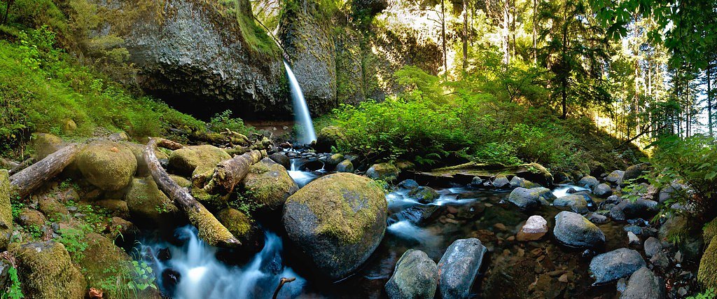
About Final Falls
Final Falls tumbles through a mossy, forested gorge in Oregon’s Mt. Hood National Forest and is managed by the U.S. Forest Service. This quieter cascade is a favorite for hikers looking for a peaceful waterfall setting away from crowds; the most direct access follows the USFS Kinzel Lake Trail (#665), which threads through old-growth stands and ferny creek banks before opening to the falls. The hike to the falls is approachable but lively — commonly described as a 2.4-mile out-and-back with roughly 350 feet of elevation gain, while USFS GIS data for Kinzel Lake Trail lists 2.03 miles. If you want to camp nearby, Camp Creek Campground is about 6.85 km away, making an easy option for an overnight stay. Because the route is on USFS-managed ground in Mt. Hood National Forest, expect a natural tread and typical forest conditions; sturdy shoes and preparation for moderate grades will make the outing more enjoyable.
The Setting
Final Falls sits at 1,982 feet within Mt. Hood National Forest, fed by the Oak Grove Fork, in the hills of Oregon.
Trail & Hike Details
The Approach
The moderate hike follows Kinzel Lake (#665), a 2.4-mile out-and-back trail over natural surface. Expect 350 feet of elevation gain with grades of 12-20%. The trail is developed (Class 3).
USFS Trail
KINZEL LAKE #665
Trail Class
Developed
Surface
Avg Grade
USFS Segment
2.03 miTrail Description
Trail name/number: Kinzel Lake Trail, Trail #665 (USFS). Surface: NATIVE MATERIAL (natural tread). Class: 3. Typical grade: 12–20%. USFS GIS miles: 2.03. Commonly reported trail length: 2.4 miles (out-and-back). Elevation gain: ~350 feet. Difficulty: moderate. Trail type: out-and-back. Expect an uneven, native-material surface with steady uphill sections and short steeper pitches in the 12–20% range. The Class 3 designation and moderate difficulty reflect occasional steeper or rockier tread where careful footing is recommended; the trail is maintained by the USFS within Mt. Hood National Forest.
What to Expect
Visitors can expect a tranquil setting with lush greenery and the soothing sound of cascading water. The area may be less developed, offering a more natural and rugged experience.
Accessibility
The trail is not wheelchair accessible. Uneven terrain and elevation changes require steady footing.
Frequently Asked Questions
🐶 Are Dogs Allowed at Final Falls?
❌ Dogs are not allowed
Are There Any Fees or Permits Required?
🆖 No fees required
🏊 Is There Swimming at Final Falls?
❌ Swimming is not allowed
When to Visit
Spring and early summer are typically the best times to visit, as water flow is likely to be at its peak due to snowmelt and rainfall.
Seasonal Access
The best time to visit is Spring, Summer, and Fall. Winter access may be limited. Check with Mt. Hood National Forest for seasonal road closures.
Safety Information
Trail conditions may be slippery, especially after rain. Be cautious of uneven terrain and potential hazards such as loose rocks or fallen branches.
Current Water Conditions
67 ft³/s
Current discharge — how much water is flowing
About average for this time of year
Based on 69 years of record
1.56 ft
Water depth at gauge
7-Day Discharge Trend
What does this mean for your visit?
Flow is about average for this time of year.
About This Gauge
This gauge is on a nearby waterway and may not reflect exact conditions at the falls.
7-Day Flow Outlook
Based on the USGS gauge OAK GROVE FORK NEAR GOVERNMENT CAMP, OR (16 km away).
Today
Moderate
76 cfs
6/10Tomorrow
Moderate
76 cfs
6/10Mon
Moderate
71 cfs
6/10Tue
Moderate
69 cfs
6/10Wed
Moderate
68 cfs
6/10Thu
Moderate
70 cfs
6/10Fri
Moderate
67 cfs
6/10Best window: Today — moderate flow, showers and thunderstorms (trip score 6/10).
Best time of year: this gauge typically runs highest from mid October to mid November, peaking in November.
How we calculate this
This is a transparent outlook, not a precise forecast. We take the waterfall's current flow strength (how it ranks against its historical normal for today, from the nearest USGS stream gauge), carry that ranking forward along the gauge's seasonal curve, and nudge it for forecast rain. Confidence is highest for the next day or two and falls further out. Always check official conditions and your own judgment before visiting — high flows can be dangerous.
Know when to go.
Get a free email alert when waterfalls near Rhododendron hit peak flow. We only send when conditions are worth the trip — no weekly newsletters, no spam.
Weather Forecast
Location & Access
Getting There
The exact location and directions to Final Falls are not well-documented. Visitors are advised to consult local resources or hiking guides for accurate directions.
Get Directions on Google MapsParking
Parking availability is unclear. Visitors should prepare for limited or informal parking options near the trailhead.
Elevation
1,982 feet above sea level
Coordinates
45.247306° N, -121.897492° W
Land Management
Managed by USFS
Visitor Tips & Gear
Bring a detailed map or GPS device as the trail and access points may not be well-marked. Wear sturdy footwear and prepare for varying trail conditions.
As an Amazon Associate, we earn from qualifying purchases.
With 2.4 miles and 350 ft of elevation gain, sturdy boots and trekking poles will help on this moderate trail. Sun exposure on the trail makes good sun protection a must in summer.

Polarized Sunglasses (Knockaround)
Cuts glare off the water so you actually see the falls — and your photos turn out better too.

Columbia Watertight II Rain Jacket
Packs into its own pocket, seam-sealed, and keeps you dry from spray and surprise rain.

Earth Pak Waterproof Dry Bag
Keeps your phone and gear dry when waterfall mist soaks everything else.

Waterproof Phone Pouch (AiRunTech)
Cheap insurance — take photos right next to the falls without killing your phone.

Timberland Euro Sprint Mid Waterproof
Trusted waterproof boot with premium leather and grippy rubber sole — reliable on rocky, wet trails.

TrailBuddy Trekking Poles
Lightweight aluminum, cork grips, and flip-locks that actually hold — a best-seller for good reason.
Where to Stay

Mount Hood Village

Mt Air Motel

Wallace Cottage - Meredith Lodging

THE CLYDE - Your Cozy & Luxurious Mt Hood Retreat
Browse vacation cabins and private rentals nearby
Unique outdoor stays — tents, yurts, and treehouses
Rent a campervan or RV for your waterfall road trip
Some links are affiliate links. We may earn a commission at no extra cost to you.
Nearby Campground
CAMP CREEK
4.3 miles away · 24 sites
Overview The Camp Creek Campground sits next to a babbling forest creek in the country's scenic Pacific Northwest region. The campground is not far from the base of the majestic, snow-covered Mt. Hood, Oregon's highest point and a prominent landmark of the area. A variety of recreational activities surround the campground, including hiking, biking and horseback riding trails, scenic views and points of exploration.Recreation Surrounding the campground are a variety of hiking and mountain biking t
Book on Recreation.govNearby Hot Springs
Hot springs near Rhododendron, Oregon

Swim Warm Springs
Swim Warm Springs emerges at 79°F within Mount Hood National Forest at 4,063 feet elevation, flowing just 6.9 meters from White...

Mount Hood Fumaroles
Mount Hood Fumaroles vent at 194°F from the flanks of Oregon's highest peak, among the state's most extreme geothermal features...

Austin Hot Springs
Austin Hot Springs discharges at 186°F along the Clackamas River at 1,680 feet elevation, emerging just 310 feet from Clackamas...
Moffetts (Bonneville) Hot Springs
Moffetts Hot Springs, also called Bonneville Hot Springs, flows at 97 degrees in the Gifford Pinchot National Forest at just 75...
Rock Creek Hot Springs
Rock Creek Hot Springs emerges in the Columbia River Gorge in Skamania County, Washington, with water documented as 'hot' witho...

Breitenbush Hot Springs
Breitenbush Hot Springs emerges at 198°F along the Breitenbush River, ranking as one of Oregon's hottest thermal features with ...
Looking for a soak after your hike? Explore more hot springs near Rhododendron, Oregon on SoakingSprings.
Explore Oregon springsAdditional Information
Nearby Attractions
Other waterfalls and hiking trails in the region may be worth exploring. Check local guides for recommendations.
Wildlife
The area may be home to a variety of wildlife, including birds, deer, and small mammals. Be cautious and respectful of the natural habitat.
Cities near Final Falls
Nearby Waterfalls

Writing about Final Falls? Embed this waterfall on your site for free.