Difficulty
Moderate
Trail Length
2.4 miles
Trail Type
Out And Back
Elevation Gain
350 ft
About Little Lee Falls
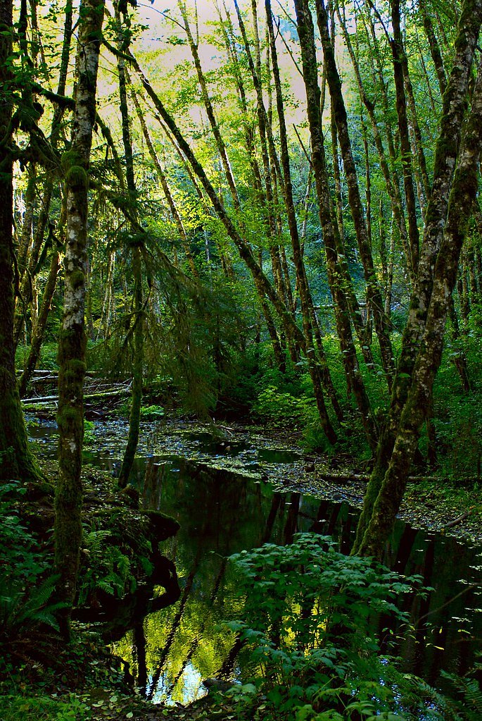
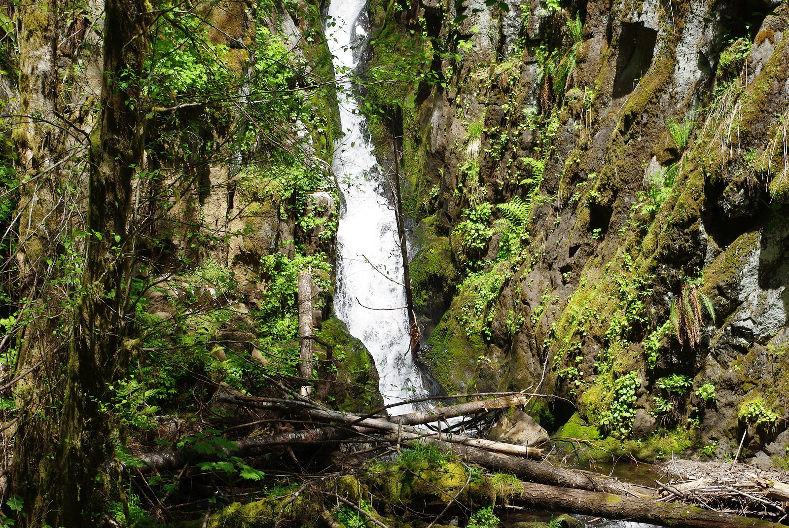
Little Lee Falls is a quietly scenic cascade tucked into the forested Tualatin River land unit in Oregon. The site sits on land owned by DESG and is managed by the Bureau of Land Management; the stream corridor carries a WSR designation, so the falls feel decidedly protected and tucked away from busier recreation corridors. Visitors can expect a peaceful, wooded ravine atmosphere—an appealing destination for hikers who prefer lesser-known, contemplative places over crowded viewpoints. Access to the falls is via a modest out-and-back hike of about 2.4 miles with roughly 350 feet of elevation gain, typically rated moderate. The approach winds through dense, mixed forest and offers a quiet, nature-focused experience rather than developed tourist infrastructure. If you’re planning an overnight trip, note that the nearest developed camping is at Dovre Recreation Site, roughly 22.6 km away, so most trips to Little Lee Falls work best as a day hike.
The Setting
Little Lee Falls sits at 295 feet within Tualatin River, fed by the Wapato Creek, in the coastal lowlands of Oregon.
Trail & Hike Details
The Approach
The moderate 2.4-mile out-and-back trail gains 350 feet of elevation on the way to the falls.
Trail Description
Trail: approximately 2.4 miles, out-and-back; elevation gain ~350 ft; difficulty: moderate. The route follows a forested track through the Tualatin River land unit and may include uneven or unmarked stretches—expect informal tread, natural surface, and typical backcountry footing. Specific USFS trail name/number, surface classifications, grade, and formal trail class data are not available for this route; the trail is best suited to hikers comfortable on moderate, occasionally rough singletrack. Carry map/navigation, sturdy footwear, and plan for limited facilities.
What to Expect
Visitors can expect a tranquil natural setting with the sound of cascading water. The area may be surrounded by dense vegetation, offering opportunities for photography and relaxation.
Accessibility
The trail is not wheelchair accessible. Uneven terrain and elevation changes require steady footing.
Frequently Asked Questions
🐶 Are Dogs Allowed at Little Lee Falls?
❌ Dogs are not allowed
Are There Any Fees or Permits Required?
🆖 No fees required
🏊 Is There Swimming at Little Lee Falls?
❌ Swimming is not allowed
When to Visit
Spring and early summer are typically the best times to visit, as water flow is likely to be at its peak due to seasonal rainfall.
Seasonal Access
The best time to visit is Spring, Summer, and Fall. Winter access may be limited.
Safety Information
Visitors should be cautious of slippery rocks, uneven terrain, and potential wildlife encounters. Always stay on marked trails if available and avoid venturing too close to the waterfall edge.
Current Water Conditions
2 ft³/s
Current discharge — how much water is flowing
About average for this time of year
Based on 4 years of record
1.59 ft
Water depth at gauge
68°F
CoolRefreshing for swimming
7-Day Discharge Trend
What does this mean for your visit?
Flow is about average for this time of year. Water temperature is a refreshing 68 degrees F, good for a quick swim. Expect low dissolved oxygen levels. PH is normal at 6.8 and mineral content is typical.
Water Quality
Dissolved Oxygen
PoorLow oxygen — stressed ecosystem
pH
NormalWithin healthy range (6.5-8.5)
Conductance
Dissolved minerals in the water
About This Gauge
This gauge is on a nearby waterway and may not reflect exact conditions at the falls.
7-Day Flow Outlook
Based on the USGS gauge WAPATO CREEK AT SW GASTON ROAD, AT GASTON, OR (11 km away).
Today
Moderate
2 cfs
4/10Tomorrow
Moderate
2 cfs
5/10Mon
Low
2 cfs
4/10Tue
Low
2 cfs
6/10Wed
Low
2 cfs
6/10Thu
Low
2 cfs
4/10Fri
Low
2 cfs
4/10Best window: Tue — low flow, partly sunny (trip score 6/10).
Best time of year: this gauge typically runs highest from late December to mid January, peaking in December.
How we calculate this
This is a transparent outlook, not a precise forecast. We take the waterfall's current flow strength (how it ranks against its historical normal for today, from the nearest USGS stream gauge), carry that ranking forward along the gauge's seasonal curve, and nudge it for forecast rain. Confidence is highest for the next day or two and falls further out. Always check official conditions and your own judgment before visiting — high flows can be dangerous.
Know when to go.
Get a free email alert when waterfalls near Cherry Grove hit peak flow. We only send when conditions are worth the trip — no weekly newsletters, no spam.
Weather Forecast
Location & Access
Getting There
The exact directions to Little Lee Falls are not widely documented. Visitors are advised to consult local maps or guides for accurate navigation. The falls may be located within a forested area, requiring some hiking to access.
Get Directions on Google MapsParking
Parking availability is unclear. Visitors should prepare for limited or informal parking options near the trailhead.
Elevation
295 feet above sea level
Coordinates
45.451264° N, -123.264340° W
Land Management
Managed by BLM
Visitor Tips & Gear
Wear sturdy footwear and bring a map or GPS device, as the trail may not be well-marked. Check weather conditions before visiting, as trails could become slippery or muddy after rain.
As an Amazon Associate, we earn from qualifying purchases.
With 2.4 miles and 350 ft of elevation gain, sturdy boots and trekking poles will help on this moderate trail. Sun exposure on the trail makes good sun protection a must in summer.

Columbia Watertight II Rain Jacket
Packs into its own pocket, seam-sealed, and keeps you dry from spray and surprise rain.

Earth Pak Waterproof Dry Bag
Keeps your phone and gear dry when waterfall mist soaks everything else.

Waterproof Phone Pouch (AiRunTech)
Cheap insurance — take photos right next to the falls without killing your phone.

Timberland Euro Sprint Mid Waterproof
Trusted waterproof boot with premium leather and grippy rubber sole — reliable on rocky, wet trails.

TrailBuddy Trekking Poles
Lightweight aluminum, cork grips, and flip-locks that actually hold — a best-seller for good reason.

Polarized Sunglasses (Knockaround)
Cuts glare off the water so you actually see the falls — and your photos turn out better too.
Where to Stay

Best Western University Inn and Suites

Larkspur Landing Extended Stay Suites Hillsboro

La Quinta by Wyndham Portland NW

Hampton Inn & Suites Tigard
Browse vacation cabins and private rentals nearby
Unique outdoor stays — tents, yurts, and treehouses
Rent a campervan or RV for your waterfall road trip
Some links are affiliate links. We may earn a commission at no extra cost to you.
Nearby Campground
Dovre Recreation Site
14 miles away · 11 sites
Overview Want to camp? Camping season is generally May-September, with Alder Glen and Elk Bend remaining open through the weekend following General Western Oregon Coast 2nd Season for elk. During months with reduced sunlight, potable water may be turned off. Be prepared to bring your own wash and drinking water. Reserve a site at one of our four campgrounds on recreation.gov or pay when you arrive for non-reserved campsites using the Recreation.gov Mobile App. You must download before you reach t
Book on Recreation.govAdditional Information
Nearby Attractions
Other natural attractions in the area may include hiking trails, forests, and additional waterfalls.
Wildlife
The area may host a variety of wildlife, including birds, deer, and small mammals. Visitors should be cautious of potential encounters with bears or other larger animals.
Cities near Little Lee Falls
Nearby Waterfalls
Writing about Little Lee Falls? Embed this waterfall on your site for free.