
Photo Credits (5)
Difficulty
Easy
Trail Length
0.4 miles
Trail Type
Out And Back
Elevation Gain
75 ft
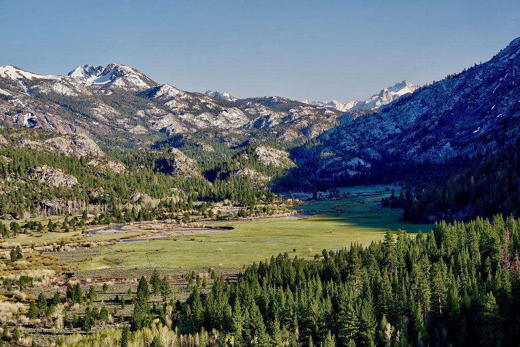
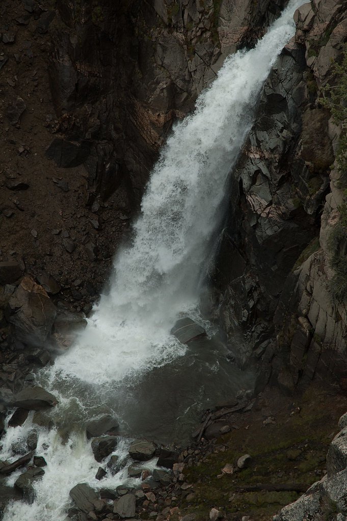
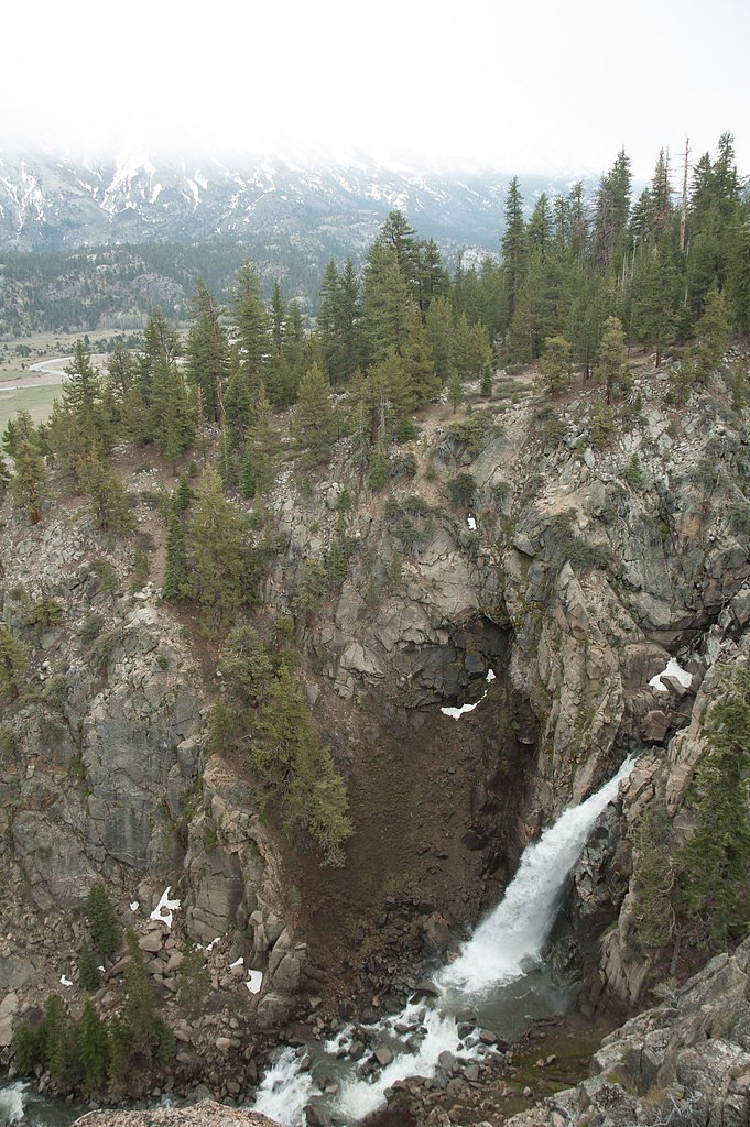
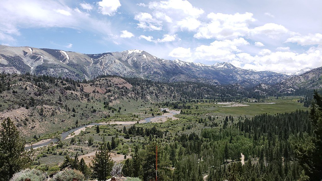
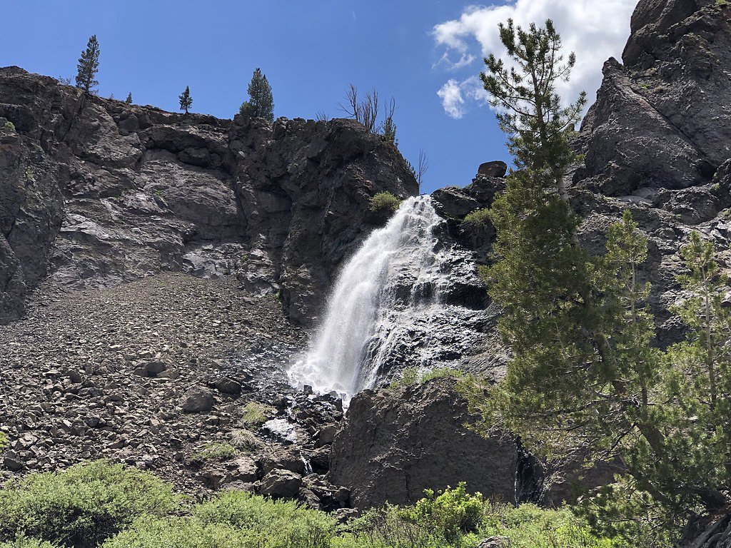
About Leavitt Falls
Leavitt Falls is a dramatic 200-foot (61 m), multi-tiered cascade tucked into the Sierra Nevada of Mono County, where Leavitt Creek plunges off a hanging valley into Leavitt Meadow. The falls and meadow are visible from a roadside turnout on Sonora Pass (Highway 108), offering sweeping views of the drop and the surrounding high-country basin. Because the creek is a tributary of the West Walker River and the falls descend into a steep, narrow box canyon, the waterfall itself sits below the rim and cannot be safely reached by trail. The land around Leavitt Falls lies within the Bridgeport military land unit and is managed by the U.S. Department of Defense, so visitors should enjoy the scene from the designated highway overlook rather than attempting cross-country approaches. The turnout at Highway 108 makes Leavitt Falls an easy, highly rewarding stop for photographers and travelers exploring the Eastern Sierra, combining big mountain scenery with a very accessible roadside viewpoint.
The Setting
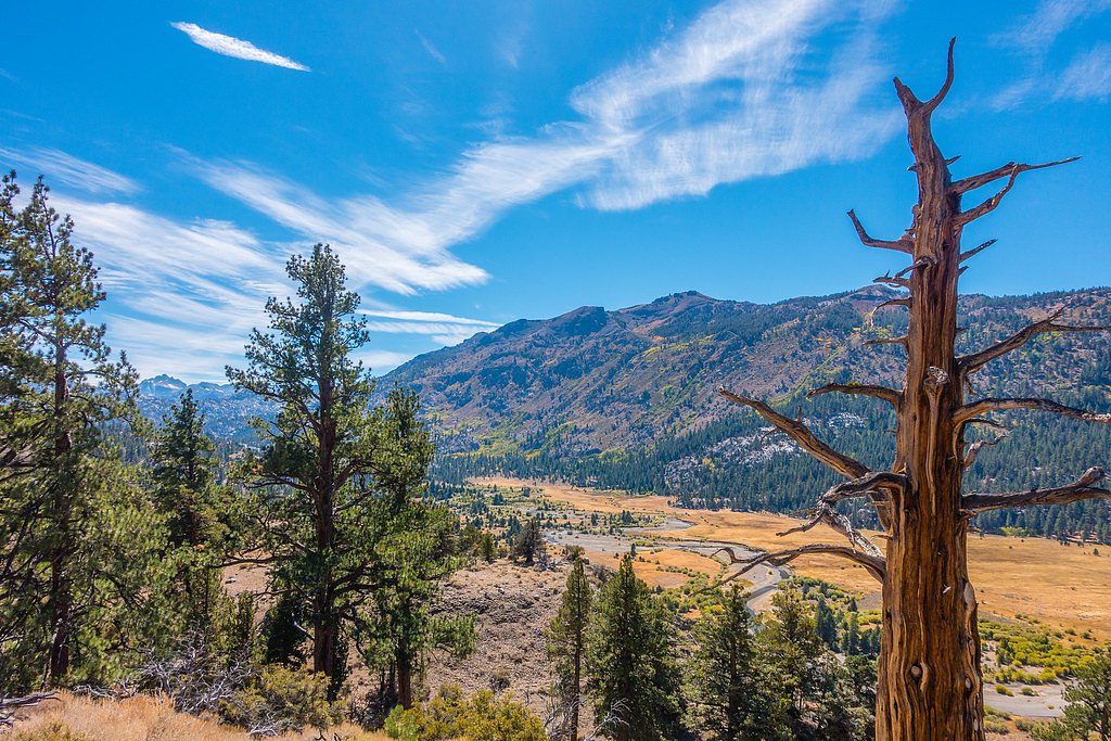
Leavitt Falls sits at 7,769 feet within Bridgeport, in the high mountains of California.
Trail & Hike Details
The Approach
The easy 0.4-mile out-and-back trail gains 75 feet of elevation on the way to the falls.
Trail Description
From the Highway 108 turnout, a short 0.4-mile out-and-back walk (about 0.4 mi round trip listed; verify signage) gains roughly 75 feet and is rated easy. There is no maintained trail that descends into the canyon to the base of the falls—the safest and most reliable view is from the highway overlook. Trail type: out-and-back; length: 0.4 miles; elevation gain: ~75 ft; difficulty: easy. Note: the falls lie in a steep, narrow box canyon and are not accessible by trail.
What to Expect
Dogs are welcome.
Accessibility
The trail is short and relatively flat, but the surface may be uneven. Contact the managing agency for accessibility details.
Frequently Asked Questions
🐶 Are Dogs Allowed at Leavitt Falls?
✅ Dogs are allowed
Are There Any Fees or Permits Required?
🆖 No fees required
🏊 Is There Swimming at Leavitt Falls?
❌ Swimming is not allowed
When to Visit
Spring and early summer are the best times to visit, as the waterfall is at its fullest due to snowmelt. Fall offers beautiful foliage, while summer provides warm weather and clear skies.
Seasonal Access
The best time to visit is Spring, Summer, and Fall. Access roads and trails may close during winter due to snow.
Safety Information
Be cautious near the edge of the viewing platform and stay on designated trails. Weather can change quickly in the mountains, so be prepared for sudden temperature drops or storms.
Current Water Conditions
293 ft³/s
Current discharge — how much water is flowing
Lower than usual for this time of year
Based on 88 years of record
2.24 ft
Water depth at gauge
7-Day Discharge Trend
What does this mean for your visit?
Flow is lower than usual for this time of year.
About This Gauge
This gauge is on a nearby waterway and may not reflect exact conditions at the falls.
7-Day Flow Outlook
Based on the USGS gauge W WALKER RV BLW L WALKER RV NR COLEVILLE, CA (12 km away).
Today
Barely Flowing
293 cfs
5/10Tomorrow
Barely Flowing
297 cfs
5/10Sun
Barely Flowing
308 cfs
5/10Mon
Barely Flowing
306 cfs
5/10Tue
Barely Flowing
302 cfs
5/10Wed
Barely Flowing
262 cfs
5/10Thu
Barely Flowing
244 cfs
5/10Best window: Today — barely flowing flow, sunny (trip score 5/10).
Best time of year: this gauge typically runs highest from mid April to mid July, peaking in June.
How we calculate this
This is a transparent outlook, not a precise forecast. We take the waterfall's current flow strength (how it ranks against its historical normal for today, from the nearest USGS stream gauge), carry that ranking forward along the gauge's seasonal curve, and nudge it for forecast rain. Confidence is highest for the next day or two and falls further out. Always check official conditions and your own judgment before visiting — high flows can be dangerous.
Know when to go.
Get a free email alert when waterfalls near Walker hit peak flow. We only send when conditions are worth the trip — no weekly newsletters, no spam.
Weather Forecast
Location & Access
Getting There
Leavitt Falls is located off Highway 108 (Sonora Pass) in Mono County, California. The falls can be accessed via a short walk from the Leavitt Falls Vista Point parking area.
Get Directions on Google MapsParking
There is a designated parking area at the Leavitt Falls Vista Point, which is free of charge. Parking is limited and may fill up during peak seasons.
Elevation
7,769 feet above sea level
Coordinates
38.319262° N, -119.562938° W
Land Management
Managed by DOD
Visitor Tips & Gear
Visit in the morning or late afternoon for the best lighting for photography. Bring binoculars or a camera with a zoom lens to get a closer view of the falls. Be prepared for cooler temperatures, especially at higher elevations.
This trail sits at 7,769 ft above sea level
Elevated TrailUV radiation is roughly 31% stronger at this elevation than at sea level, and the dry air accelerates dehydration. Extra sun protection and fluids go a long way.
As an Amazon Associate, we earn from qualifying purchases.

Coppertone Sport SPF 50 Sunscreen
UV intensity jumps ~4% per 1,000 ft — at this elevation you can burn in half the time.

Sun Bum SPF 30 Lip Balm (3-Pack)
Lips have almost no natural UV protection and burn fast in thin, dry mountain air.

Liquid I.V. Electrolyte Packets
You lose moisture ~2x faster at elevation — electrolytes help you absorb water efficiently.

ROCKNIGHT Polarized UV400 Sunglasses
High-altitude glare off rock and water is intense — UV400 lenses block 99%+ of UVA/UVB.
As an Amazon Associate, we earn from qualifying purchases.
For this easy 0.4 miles trail, lightweight trail shoes and a water bottle are usually sufficient. Sun exposure on the trail makes good sun protection a must in summer.

Polarized Sunglasses (Knockaround)
Cuts glare off the water so you actually see the falls — and your photos turn out better too.

Columbia Watertight II Rain Jacket
Packs into its own pocket, seam-sealed, and keeps you dry from spray and surprise rain.

Earth Pak Waterproof Dry Bag
Keeps your phone and gear dry when waterfall mist soaks everything else.

Waterproof Phone Pouch (AiRunTech)
Cheap insurance — take photos right next to the falls without killing your phone.

JOBY GorillaPod Starter Kit
Wraps around railings and rocks for long-exposure waterfall shots — no flat surface needed.

Osprey Daylite Daypack
Light, organized, and just the right size for a day hike — fits water, snacks, and layers.
Where to Stay

Silver Maple Inn

The Long Barn Lodge

Ruby Inn Bridgeport

Mountain Getaway with Granny Unit, Dogs Ok #47
Browse vacation cabins and private rentals nearby
Unique outdoor stays — tents, yurts, and treehouses
Rent a campervan or RV for your waterfall road trip
Some links are affiliate links. We may earn a commission at no extra cost to you.
Nearby Campground
Obsidian Campground
6.3 miles away · 0 sites
Obsidian Campground offers opportunity to get away from crowds amidst shade of aspens and pines. Campground is close to Molybdenite Creek and Little Walker River. The river is stocked with trout. Area trailheads offer several interesting hikes. The trail from Molybdenite Creek trailhead splits, with one branch heading south into the Hoover Wilderness, and one looping north along Wheeler Creek to connect with the trail along the Little Walker River. This can be hiked as a loop from Burt Canyon tra
Book on Recreation.govNearby Hot Springs
Hot springs near Walker, California
Fales Hot Springs
Fales Hot Springs reaches 180°F in the high Sierra Nevada, flowing 137°F hotter than the surrounding air at 7,491 feet elevatio...
Buckeye Hot Spring
Buckeye Hot Spring flows at 140°F from the eastern Sierra Nevada in Mono County at 6,963 feet elevation on US Forest Service la...
Unnamed Spring Lyon County
This unnamed warm spring emerges in Lyon County, Nevada near Smith Valley at 5,019 feet elevation, sitting virtually roadside j...

Travertine Hot Springs
Travertine Hot Springs delivers scalding 180°F water in Mono County near Bridgeport, creating one of the eastern Sierra Nevada'...
The Hot Springs
The Hot Springs delivers 113°F water in Mono County near Bridgeport, a comfortable temperature in the eastern Sierra Nevada whe...
Warm Spring
Warm Spring flows at 77°F near Bridgeport in California's High Sierra, rising 33.5 degrees above the 43.5°F annual average in a...
Looking for a soak after your hike? Explore more hot springs near Walker, California on SoakingSprings.
Explore California springsAdditional Information
Nearby Attractions
Nearby attractions include Sonora Pass, Leavitt Lake, and the Hoover Wilderness, which offer additional hiking and scenic opportunities.
Wildlife
The area is home to a variety of wildlife, including deer, marmots, and birds of prey. Keep an eye out for these animals during your visit.
Cities near Leavitt Falls
Nearby Waterfalls
Other waterfalls named Leavitt Falls
1 other waterfall shares this name across the U.S.
Writing about Leavitt Falls? Embed this waterfall on your site for free.