Difficulty
Easy
Trail Length
1.0 miles
Trail Type
Out And Back
Elevation Gain
100 ft
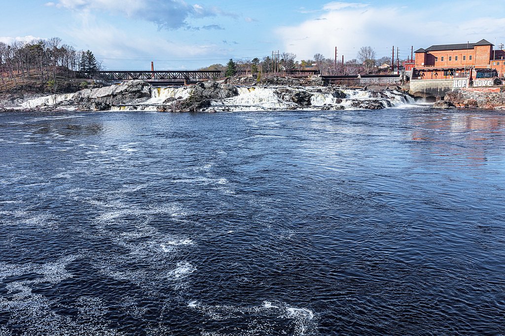
About Holmes Falls
Holmes Falls is a scenic waterfall in Washington County, Maine, set within the Machias River Watershed - Asc land unit. The cascade sits on private land (land owner: PVT) with a conservation designation (CONE) and is listed under a non-federal manager (OTHs). The falls tumble over rocky ledges into a tranquil pool, offering a compact, peaceful destination for a short outdoor outing. Access is straightforward and suited to visitors looking for an easy, scenic stop rather than a long backcountry trek. Because the site lies on private conserved land, visitors should observe any posted access guidelines and leave no trace. The setting’s quiet atmosphere makes it a pleasant spot for photography, a brief picnic, or a relaxing break along the Machias River watershed.
The Setting
Holmes Falls sits at 85 feet within Machias River Watershed - Asc, fed by the Libby Brook, in the coastal lowlands of Maine.
Trail & Hike Details
The Approach
The easy 1.0-mile out-and-back trail gains 100 feet of elevation on the way to the falls.
Trail Description
Trail type: out-and-back. Distance: 1.0 miles. Elevation gain: approximately 100 feet. Difficulty: easy. The route is a short, gentle hike suitable for most visitors; expect a modest grade over a short distance and plan for a brief walk in and back to the falls. No USFS trail number or surface/class data are provided for this route.
What to Expect
Dogs are welcome.
Accessibility
The trail is not wheelchair accessible. Uneven terrain and elevation changes require steady footing.
Frequently Asked Questions
🐶 Are Dogs Allowed at Holmes Falls?
✅ Dogs are allowed
Are There Any Fees or Permits Required?
🆖 No fees required
🏊 Is There Swimming at Holmes Falls?
❌ Swimming is not allowed
When to Visit
Spring and early summer are ideal times to visit, as the water flow is typically strongest during these seasons. Fall offers beautiful foliage, while summer provides warmer weather for a comfortable hike.
Seasonal Access
The best time to visit is Spring, Summer, and Fall. Winter access may be limited.
Safety Information
Exercise caution near the falls, as the rocks can be slippery. Be prepared for limited cell service in the area. Check weather conditions before visiting, as the trail may become muddy or difficult to navigate after heavy rain.
Current Water Conditions
13 ft³/s
Current discharge — how much water is flowing
About average for this time of year
Based on 25 years of record
1.85 ft
Water depth at gauge
7-Day Discharge Trend
What does this mean for your visit?
Flow is about average for this time of year.
About This Gauge
7-Day Flow Outlook
Based on the USGS gauge Libby Brook near Northfield, Maine (4 km away).
Today
Moderate
14 cfs
6/10Tomorrow
Strong
16 cfs
7/10Sun
Strong
18 cfs
7/10Mon
Moderate
16 cfs
9/10Tue
Moderate
17 cfs
6/10Wed
Moderate
16 cfs
6/10Thu
Moderate
18 cfs
6/10Best window: Mon — moderate flow, sunny (trip score 9/10).
Best time of year: this gauge typically runs highest from mid March to early May, peaking in April.
How we calculate this
This is a transparent outlook, not a precise forecast. We take the waterfall's current flow strength (how it ranks against its historical normal for today, from the nearest USGS stream gauge), carry that ranking forward along the gauge's seasonal curve, and nudge it for forecast rain. Confidence is highest for the next day or two and falls further out. Always check official conditions and your own judgment before visiting — high flows can be dangerous.
Know when to go.
Get a free email alert when waterfalls near Jonesport hit peak flow. We only send when conditions are worth the trip — no weekly newsletters, no spam.
Weather Forecast
Location & Access
Getting There
Holmes Falls is located in the Holmes Falls Preserve, near the town of Calais, Maine. Access is via a dirt road, and visitors should follow signs for the preserve. The area is remote, so a reliable map or GPS is recommended.
Get Directions on Google MapsParking
There is a small parking area near the trailhead, but space may be limited.
Elevation
85 feet above sea level
Coordinates
44.796464° N, -67.672219° W
Land Management
Managed by OTHS
Visitor Tips & Gear
Wear sturdy shoes, as the trail may be muddy or uneven in places. Bring bug spray during warmer months, as mosquitoes and other insects can be present. Cell service may be limited, so plan accordingly.
As an Amazon Associate, we earn from qualifying purchases.
This easy 1.0 miles hike is straightforward — comfortable trail shoes and plenty of water should do. Sun exposure on the trail makes good sun protection a must in summer.

Columbia Watertight II Rain Jacket
Packs into its own pocket, seam-sealed, and keeps you dry from spray and surprise rain.

Earth Pak Waterproof Dry Bag
Keeps your phone and gear dry when waterfall mist soaks everything else.

Waterproof Phone Pouch (AiRunTech)
Cheap insurance — take photos right next to the falls without killing your phone.

Polarized Sunglasses (Knockaround)
Cuts glare off the water so you actually see the falls — and your photos turn out better too.

Osprey Daylite Daypack
Light, organized, and just the right size for a day hike — fits water, snacks, and layers.

OR Sombriolet Sun Hat
UPF 50+ sun protection with vents so your head doesn't cook on exposed trail sections.
Where to Stay

Oceanfront Sunset View Cabin

Robinson's Cottages

Coastal Red Farmhouse w/Firepit - Holiday Home

Cozy Coastal Cabin 4
Browse vacation cabins and private rentals nearby
Unique outdoor stays — tents, yurts, and treehouses
Rent a campervan or RV for your waterfall road trip
Some links are affiliate links. We may earn a commission at no extra cost to you.
Additional Information
Nearby Attractions
Nearby attractions include the Moosehorn National Wildlife Refuge and the town of Calais, which offers dining and shopping options.
Wildlife
The area is home to a variety of wildlife, including birds, deer, and small mammals. Visitors may also see wildflowers and other native plants along the trail.
Cities near Holmes Falls
Nearby Waterfalls

Writing about Holmes Falls? Embed this waterfall on your site for free.