Photo Credits (4)
Difficulty
Moderate
Trail Length
2.0 miles
Trail Type
Out And Back
Elevation Gain
500 ft
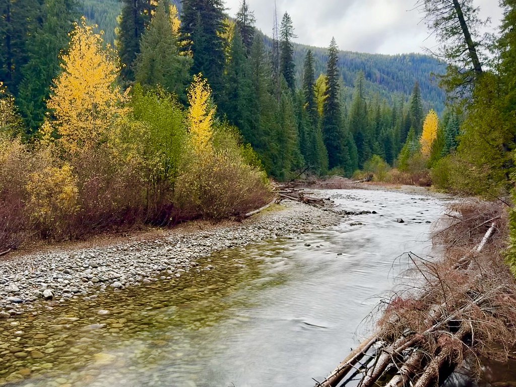
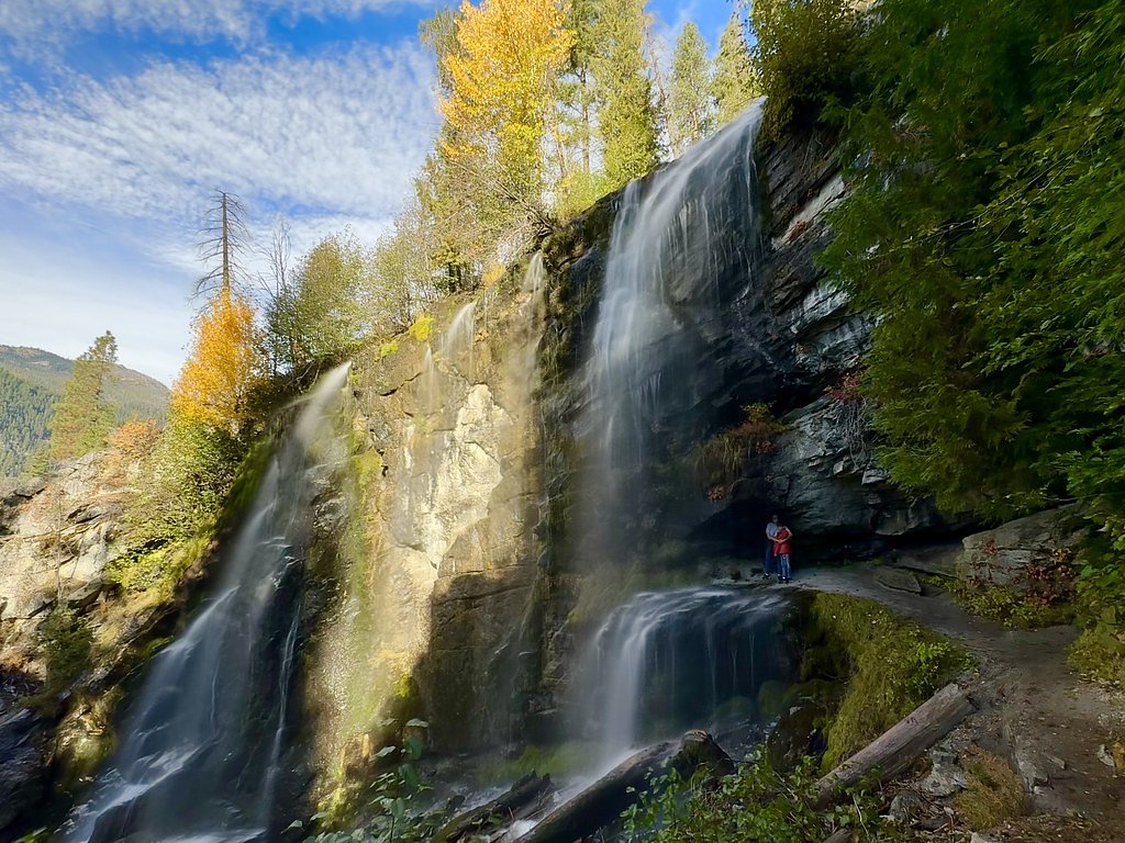
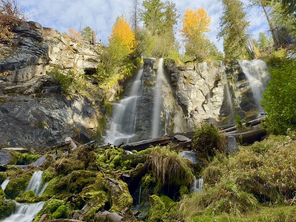
About Entiat Falls
Entiat Falls sits in the lush Entiat Valley along the Entiat River, nestled within the Wenatchee National Forest and managed by the U.S. Forest Service. The falls are an accessible reward for a relatively short trek through mixed conifer forest and riparian scenery; the approach is popular with day hikers and photographers who want a quick immersion in classic Cascade River country. The route to the falls follows a segment of the Entiat River corridor that is also designated by the Forest Service as the Entiat River Snowmobile Trail (Trail #SNO-5100). The hike to the viewpoint is a moderate 2.0-mile out-and-back with about 500 feet of elevation gain, and Silver Falls Group Site campground is nearby—only about 3.94 km away—making this an easy addition for groups planning an overnight stay in the Wenatchee National Forest.
The Setting
Entiat Falls sits at 2,661 feet within Wenatchee National Forest, fed by the Chiwawa River, in the hills of Washington.
Trail & Hike Details
The Approach
The moderate hike follows Entiat River Snowmobile (#SNO-5100), a 2.0-mile out-and-back trail over n/a. Expect 500 feet of elevation gain with grades of N/A.
USFS Trail
ENTIAT RIVER SNOWMOBILE #SNO-5100
Trail Class
Class 0
Surface
Avg Grade
USFS Segment
12.37 miTrail Description
This out-and-back route to Entiat Falls is listed at 2.0 miles round trip with roughly 500 feet of elevation gain and a moderate difficulty rating. The tread follows the Entiat River and uses the Forest Service route identified as Entiat River Snowmobile, Trail #SNO-5100 (the full SNO-5100 route is mapped at 12.37 GIS miles by the USFS). The USFS class for this trail is recorded as "N"; surface and typical grade are listed as N/A in Forest Service data. The path is generally well-maintained but may include some rocky or uneven sections—good footwear and typical day-hiking preparations are recommended. Silver Falls Group Site campground lies about 3.94 km from the trailhead for those looking to camp nearby.
What to Expect
Dogs are welcome.
Accessibility
The trail is not wheelchair accessible. Uneven terrain and elevation changes require steady footing.
Frequently Asked Questions
🐶 Are Dogs Allowed at Entiat Falls?
✅ Dogs are allowed
Are There Any Fees or Permits Required?
🤑 Fee: $5.00
Permit required
A Northwest Forest Pass or equivalent is required for parking at trailheads in the Okanogan-Wenatchee National Forest.
🏊 Is There Swimming at Entiat Falls?
❌ Swimming is not allowed
When to Visit
Spring and early summer are the best times to visit, as the waterfall is most impressive during peak snowmelt.
Seasonal Access
The best time to visit is Spring, Summer, and Fall. Winter access may be limited. Check with Wenatchee National Forest for seasonal road closures.
Safety Information
Be cautious of slippery rocks near the waterfall. Always stay on marked trails and avoid getting too close to the edge of the falls. Check weather conditions before visiting, as rain or snow can make the trail hazardous.
Current Water Conditions
633 ft³/s
Current discharge — how much water is flowing
Lower than usual for this time of year
Based on 53 years of record
5.10 ft
Water depth at gauge
7-Day Discharge Trend
What does this mean for your visit?
Flow is lower than usual for this time of year.
About This Gauge
This gauge is on a nearby waterway and may not reflect exact conditions at the falls.
7-Day Flow Outlook
Based on the USGS gauge CHIWAWA RIVER NEAR PLAIN, WA (18 km away).
Today
Low
667 cfs
4/10Tomorrow
Low
635 cfs
4/10Sat
Low
590 cfs
4/10Sun
Low
553 cfs
6/10Mon
Barely Flowing
542 cfs
5/10Tue
Barely Flowing
537 cfs
5/10Wed
Barely Flowing
527 cfs
5/10Best window: Sun — low flow, partly sunny (trip score 6/10).
Best time of year: this gauge typically runs highest from mid April to mid July, peaking in June.
How we calculate this
This is a transparent outlook, not a precise forecast. We take the waterfall's current flow strength (how it ranks against its historical normal for today, from the nearest USGS stream gauge), carry that ranking forward along the gauge's seasonal curve, and nudge it for forecast rain. Confidence is highest for the next day or two and falls further out. Always check official conditions and your own judgment before visiting — high flows can be dangerous.
Know when to go.
Get a free email alert when waterfalls near Manson hit peak flow. We only send when conditions are worth the trip — no weekly newsletters, no spam.
Weather Forecast
Location & Access
Getting There
Entiat Falls is located in the Okanogan-Wenatchee National Forest. To reach the falls, visitors typically drive along the Entiat River Road, which is accessible from the town of Entiat, Washington. The falls are located near the Entiat River Trail.
Get Directions on Google MapsParking
Parking is available at trailheads along the Entiat River Trail. Availability may vary depending on the season and trailhead location.
Elevation
2,661 feet above sea level
Coordinates
47.985408° N, -120.575095° W
Land Management
Managed by USFS
Visitor Tips & Gear
Wear sturdy hiking shoes and bring plenty of water. Check trail conditions before visiting, especially in spring when snowmelt can make trails muddy or slippery. Bug spray is recommended during summer months.
As an Amazon Associate, we earn from qualifying purchases.
With 2.0 miles and 500 ft of elevation gain, sturdy boots and trekking poles will help on this moderate trail. Sun exposure on the trail makes good sun protection a must in summer.

Polarized Sunglasses (Knockaround)
Cuts glare off the water so you actually see the falls — and your photos turn out better too.

Columbia Watertight II Rain Jacket
Packs into its own pocket, seam-sealed, and keeps you dry from spray and surprise rain.

Earth Pak Waterproof Dry Bag
Keeps your phone and gear dry when waterfall mist soaks everything else.

Waterproof Phone Pouch (AiRunTech)
Cheap insurance — take photos right next to the falls without killing your phone.

Timberland Euro Sprint Mid Waterproof
Trusted waterproof boot with premium leather and grippy rubber sole — reliable on rocky, wet trails.

TrailBuddy Trekking Poles
Lightweight aluminum, cork grips, and flip-locks that actually hold — a best-seller for good reason.
Where to Stay

Peaceful Entiat Home Pets Welcome!

Maple Leaf Lodge by NW Comfy Cabins

Leavenworth Cabin w/ Private Hot Tub!

All About the Lake by NW Comfy Cabins
Browse vacation cabins and private rentals nearby
Unique outdoor stays — tents, yurts, and treehouses
Rent a campervan or RV for your waterfall road trip
Some links are affiliate links. We may earn a commission at no extra cost to you.
Nearby Campground
SILVER FALLS GROUP SITE
2.4 miles away · 1 sites
Overview Silver Falls Group Campground sits in forested, mountain terrain on the banks of the Entiat River in the Okanogan-Wenatchee National Forest in the Entiat Ranger District. The cascading water of Silver Falls is a draw for many visitors to this particular area, which is especially refreshing in the summer heat. The Silver Falls National Recreation Trail is an exceptional family hike taking you up, around and down the falls. Panoramic views of the surrounding mountains await you on the hike
Book on Recreation.govNearby Hot Springs
Hot springs near Manson, Washington
Gamma Hot Springs
Gamma Hot Springs produces 140-degree water at 5,397 feet elevation in the Mt. Baker National Forest, emerging 104.6 degrees ab...
Kennedy Hot Spring
Kennedy Hot Spring flows at 100 degrees at 3,520 feet elevation in the Mt. Baker National Forest, emerging 58.7 degrees above a...
Garland Mineral Springs
Garland Mineral Springs flows at 84 degrees in the Snoqualmie National Forest, producing water 39.6 degrees above ambient tempe...
Scenic Hot Springs
Scenic Hot Springs delivers genuinely hot water at 122 degrees Fahrenheit at 2,246 feet elevation in the Cascade Mountains near...
Sulphur Creek Hot Springs
Sulphur Creek Hot Springs flows at 99 degrees Fahrenheit at 2,973 feet elevation in Mount Baker National Forest's remote backco...
Goldmeyer Hot Springs
Goldmeyer Hot Springs emerges at 127 degrees in the central Cascades, producing water 78.9 degrees above ambient temperature at...
Looking for a soak after your hike? Explore more hot springs near Manson, Washington on SoakingSprings.
Explore Washington springsAdditional Information
Nearby Attractions
Other attractions in the area include Silver Falls, the Entiat River Trail, and various camping sites within the Okanogan-Wenatchee National Forest.
Wildlife
The area is home to deer, birds, and other forest wildlife. Visitors should be cautious of bears and carry bear spray if hiking in remote areas.
Cities near Entiat Falls
Nearby Waterfalls

Writing about Entiat Falls? Embed this waterfall on your site for free.