Difficulty
Moderate
Trail Length
2.0 miles
Trail Type
Out And Back
Elevation Gain
300 ft
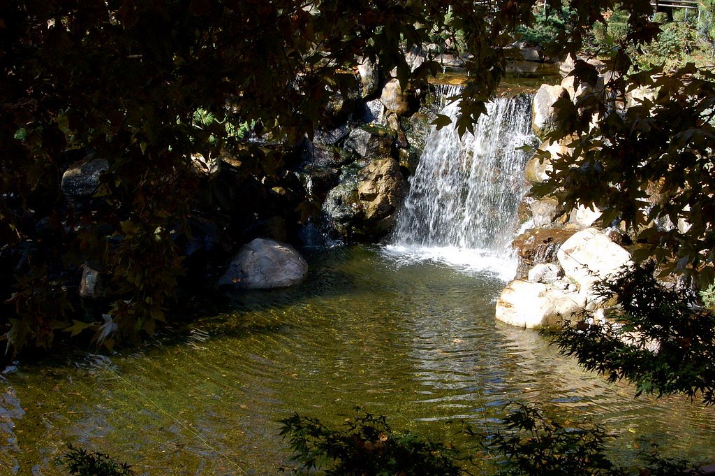
About Ella Falls
Ella Falls is a quietly scenic cascade tucked inside Kings Canyon National Park and managed by the National Park Service. A lesser-known gem, the falls sit amid lush forest and offer a peaceful retreat for hikers who prefer quieter trails. Because the site is on NPS land, visitors should follow park regulations and Leave No Trace practices while exploring this natural spot. The waterfall is most easily reached via a moderate, 2.0-mile out-and-back route that gains about 300 feet—making it a doable half-day excursion for most hikers comfortable with uneven terrain. If you’re camping, Sunset Campground (CA) lies just about 1.39 km away and provides a convenient base for an overnight stay before or after your visit to the falls.
The Setting
Ella Falls sits at 5,702 feet within Kings Canyon National Park, in the high mountains of California.
Trail & Hike Details
The Approach
The moderate 2.0-mile out-and-back trail gains 300 feet of elevation on the way to the falls.
Trail Description
The trail to Ella Falls is a 2.0-mile out-and-back with roughly 300 feet of elevation gain and a moderate difficulty rating. The path winds through forested terrain with occasional clearings and some rocky, uneven sections; sturdy footwear and basic trail navigation skills are recommended. As the route is managed within Kings Canyon National Park by the National Park Service, expect maintained but natural surfaces and follow posted park guidance for trails and backcountry use.
What to Expect
Visitors can expect a tranquil hike through nature, culminating in a beautiful waterfall surrounded by greenery. The area may be less crowded compared to more popular waterfalls in California.
Accessibility
The trail is not wheelchair accessible. Uneven terrain and elevation changes require steady footing.
Frequently Asked Questions
🐶 Are Dogs Allowed at Ella Falls?
❌ Dogs are not allowed
Are There Any Fees or Permits Required?
🆖 No fees required
🏊 Is There Swimming at Ella Falls?
❌ Swimming is not allowed
When to Visit
Spring and early summer are the best times to visit, as the waterfall is likely to have the most water flow due to snowmelt and seasonal rains.
Seasonal Access
The best time to visit is Spring, Summer, and Fall. Access roads and trails may close during winter due to snow. Check the National Park Service website for current conditions.
Safety Information
The trail may have uneven terrain and slippery sections near the waterfall. Always stay on marked paths and avoid getting too close to the edge of the falls. Check weather conditions before your visit, as rain can make the trail more hazardous.
Know when to go.
Get a free email alert when waterfalls near Wilsonia hit peak flow. We only send when conditions are worth the trip — no weekly newsletters, no spam.
Weather Forecast
Location & Access
Getting There
Ella Falls is located in a remote area of California. Access typically requires driving to a trailhead followed by a hike. Exact directions may vary depending on the starting point, so consulting a reliable map or GPS is recommended.
Get Directions on Google MapsParking
Parking is available near the trailhead, but spaces may be limited during peak seasons.
Elevation
5,702 feet above sea level
Coordinates
36.731765° N, -118.978407° W
Land Management
Managed by NPS
Visitor Tips & Gear
Start your hike early to avoid crowds and ensure you have enough daylight for the return trip. Bring plenty of water and snacks, as there are no facilities along the trail.
This trail sits at 5,702 ft above sea level
Elevated TrailUV radiation is roughly 23% stronger at this elevation than at sea level, and the dry air accelerates dehydration. Extra sun protection and fluids go a long way.
As an Amazon Associate, we earn from qualifying purchases.

Coppertone Sport SPF 50 Sunscreen
UV intensity jumps ~4% per 1,000 ft — at this elevation you can burn in half the time.

Sun Bum SPF 30 Lip Balm (3-Pack)
Lips have almost no natural UV protection and burn fast in thin, dry mountain air.

Liquid I.V. Electrolyte Packets
You lose moisture ~2x faster at elevation — electrolytes help you absorb water efficiently.

ROCKNIGHT Polarized UV400 Sunglasses
High-altitude glare off rock and water is intense — UV400 lenses block 99%+ of UVA/UVB.
As an Amazon Associate, we earn from qualifying purchases.
With 2.0 miles and 300 ft of elevation gain, sturdy boots and trekking poles will help on this moderate trail. Sun exposure on the trail makes good sun protection a must in summer.
America the Beautiful Annual Pass
Covers entrance fees at 2,000+ federal recreation sites — required at most National Parks.

Columbia Watertight II Rain Jacket
Packs into its own pocket, seam-sealed, and keeps you dry from spray and surprise rain.

Earth Pak Waterproof Dry Bag
Keeps your phone and gear dry when waterfall mist soaks everything else.

Waterproof Phone Pouch (AiRunTech)
Cheap insurance — take photos right next to the falls without killing your phone.

Timberland Euro Sprint Mid Waterproof
Trusted waterproof boot with premium leather and grippy rubber sole — reliable on rocky, wet trails.

TrailBuddy Trekking Poles
Lightweight aluminum, cork grips, and flip-locks that actually hold — a best-seller for good reason.

Polarized Sunglasses (Knockaround)
Cuts glare off the water so you actually see the falls — and your photos turn out better too.
Where to Stay

Cozy Cottage

Sequoia Resort

Fivespot Cabin

Seven Circles Lodge&Retreat
Browse vacation cabins and private rentals nearby
Unique outdoor stays — tents, yurts, and treehouses
Rent a campervan or RV for your waterfall road trip
Some links are affiliate links. We may earn a commission at no extra cost to you.
Nearby Campground
SUNSET CAMPGROUND (CA)
0.9 miles away · 156 sites
Overview Sunset campground is centrally located in Sequoia and Kings Canyon National Parks in central California's rugged Sierra Nevada range. This campground is at an elevation of 6,500 feet. A number of hiking trails begin within walking distance of the campground including the one mile trail to the General Grant Tree. Recreation There are numerous recreation opportunities in the immediate area. From your campsite, you can hike to a sequoia grove that includes the General Grant Tree, the Nation
Book on Recreation.govNearby Hot Springs
Hot springs near Wilsonia, California

Blaney Meadows Hot Springs
Blaney Meadows Hot Springs emerges at 109 degrees Fahrenheit from the Sierra National Forest at 7,676 feet elevation, deliverin...

Mono Hot Springs
Mono Hot Springs emerges at 109°F in the High Sierra's alpine terrain, set at 6,561 feet where thermal water feeds a series of ...

Soda Spring
Soda Spring emerges at 72°F in the Tulare County foothills near East Porterville, offering modest thermal warmth just 8 degrees...
Kern Hot Spring
Kern Hot Spring emerges at 109°F in Sequoia National Park at 6,908 feet elevation, accessible only via backcountry hiking. Prot...
Ward Spring
Ward Spring flows at 70 degrees in Tulare County's southern Sierra Nevada foothills, producing water only 9.9 degrees above amb...
Unnamed Spring Mono County 1
High in the Sierra National Forest near Mammoth Lakes, this 95-degree thermal spring flows at 5,585 feet elevation, creating 46...
Looking for a soak after your hike? Explore more hot springs near Wilsonia, California on SoakingSprings.
Explore California springsAdditional Information
Nearby Attractions
Nearby hiking trails and scenic viewpoints may be available in the surrounding area.
Wildlife
The area is home to various wildlife, including birds, deer, and small mammals. Be cautious of potential encounters with snakes or other animals.
Cities near Ella Falls
Nearby Waterfalls
Writing about Ella Falls? Embed this waterfall on your site for free.