Difficulty
Moderate
Trail Length
2.4 miles
Trail Type
Out And Back
Elevation Gain
350 ft
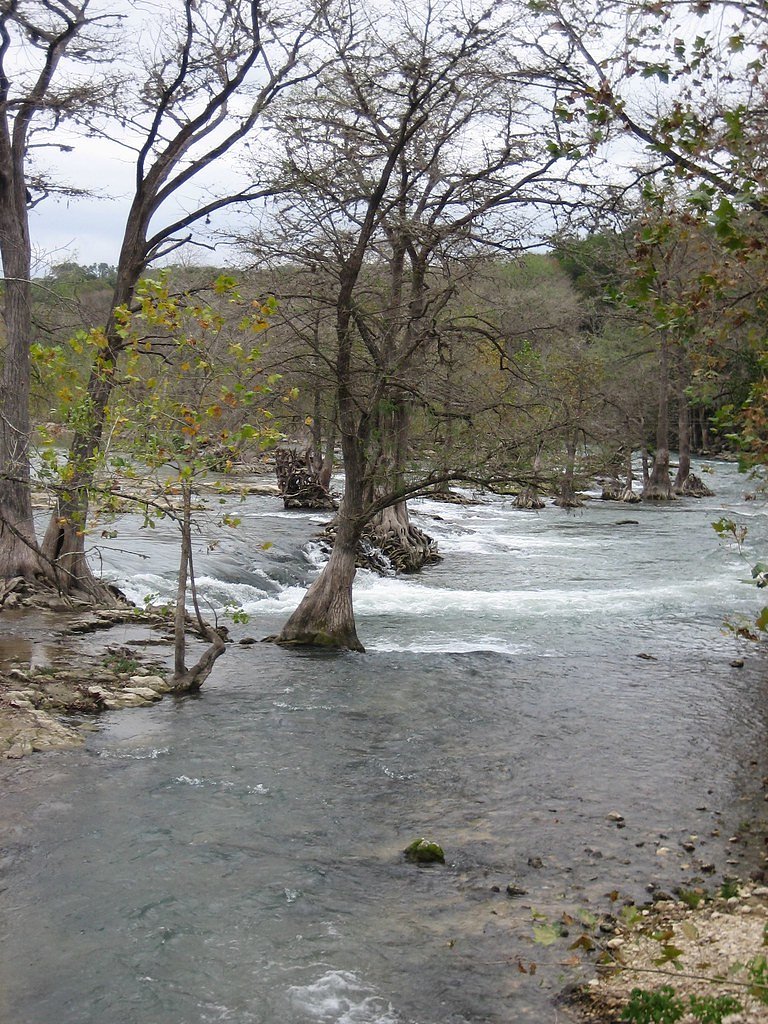
About Dittmar Falls
Dittmar Falls is a tucked-away Texas cascade that offers a quiet, natural setting for hikers willing to seek it out. Because the falls are not widely documented, water flow is highly seasonal — a modest trickle in dry periods and a stronger drop after significant rainfall — making each visit a slightly different experience. Access to the falls is via a roughly 2.4-mile out-and-back route with about 350 feet of elevation gain, rated moderate. The approach rewards those looking for solitude more than folks seeking a heavily maintained attraction; expect an informal path and uneven terrain, and come prepared with good navigation and sturdy footwear for a pleasant half-day outing.
Trail & Hike Details
The Approach
The moderate 2.4-mile out-and-back trail gains 350 feet of elevation on the way to the falls.
Trail Description
Trail length: 2.4 miles (out-and-back). Elevation gain: approximately 350 feet. Difficulty: moderate. Trail type: out-and-back. Official surface, grade, and any USFS trail number or class are not documented in the available records. The route may include faint or unmarked sections and occasional off-trail navigation, so plan for uneven footing and natural obstacles. Essential preparation includes sturdy shoes, plenty of water, and a reliable map or GPS device.
What to Expect
Visitors can expect a quiet and natural environment. The waterfall's flow may depend on recent rainfall, and the surrounding area may be rugged or undeveloped.
Accessibility
The trail is not wheelchair accessible. Uneven terrain and elevation changes require steady footing.
Frequently Asked Questions
🐶 Are Dogs Allowed at Dittmar Falls?
❌ Dogs are not allowed
Are There Any Fees or Permits Required?
🆖 No fees required
🏊 Is There Swimming at Dittmar Falls?
❌ Swimming is not allowed
When to Visit
Spring and after periods of rainfall are typically the best times to visit, as the waterfall's flow may be more prominent.
Seasonal Access
The best time to visit is Spring, Summer, and Fall. Winter access may be limited.
Safety Information
The area may have uneven terrain, unmarked trails, and potential wildlife hazards. Visitors should exercise caution, stay aware of their surroundings, and avoid visiting during inclement weather.
Current Water Conditions
202 ft³/s
Current discharge — how much water is flowing
About average for this time of year
Based on 93 years of record
3.87 ft
Water depth at gauge
7-Day Discharge Trend
What does this mean for your visit?
Flow is about average for this time of year.
About This Gauge
This gauge is on a nearby waterway and may not reflect exact conditions at the falls.
7-Day Flow Outlook
Based on the USGS gauge Comal Rv at New Braunfels, TX (8 km away).
Today
Low
215 cfs
6/10Tomorrow
Low
214 cfs
6/10Thu
Low
214 cfs
6/10Fri
Low
217 cfs
6/10Sat
Moderate
244 cfs
4/10Sun
Moderate
250 cfs
5/10Mon
Low
222 cfs
6/10Best window: Today — low flow, sunny (trip score 6/10).
Best time of year: this gauge typically runs highest from early February to mid February, peaking in January.
How we calculate this
This is a transparent outlook, not a precise forecast. We take the waterfall's current flow strength (how it ranks against its historical normal for today, from the nearest USGS stream gauge), carry that ranking forward along the gauge's seasonal curve, and nudge it for forecast rain. Confidence is highest for the next day or two and falls further out. Always check official conditions and your own judgment before visiting — high flows can be dangerous.
Know when to go.
Get a free email alert when waterfalls near Lake Dunlap hit peak flow. We only send when conditions are worth the trip — no weekly newsletters, no spam.
Weather Forecast
Location & Access
Getting There
The exact location and directions to Dittmar Falls are not well-documented. Visitors are advised to consult local guides or resources for accurate directions.
Get Directions on Google MapsParking
Parking availability is unclear. Visitors should prepare for limited or no designated parking areas near the falls.
Elevation
541 feet above sea level
Coordinates
29.653282° N, -98.064452° W
Visitor Tips & Gear
Bring a detailed map or GPS device as the location is not well-marked. Wear sturdy footwear and prepare for uneven terrain. Check weather conditions before visiting.
As an Amazon Associate, we earn from qualifying purchases.
With 2.4 miles and 350 ft of elevation gain, sturdy boots and trekking poles will help on this moderate trail. Sun exposure on the trail makes good sun protection a must in summer.

Columbia Watertight II Rain Jacket
Packs into its own pocket, seam-sealed, and keeps you dry from spray and surprise rain.

Earth Pak Waterproof Dry Bag
Keeps your phone and gear dry when waterfall mist soaks everything else.

Waterproof Phone Pouch (AiRunTech)
Cheap insurance — take photos right next to the falls without killing your phone.

Timberland Euro Sprint Mid Waterproof
Trusted waterproof boot with premium leather and grippy rubber sole — reliable on rocky, wet trails.

TrailBuddy Trekking Poles
Lightweight aluminum, cork grips, and flip-locks that actually hold — a best-seller for good reason.

Polarized Sunglasses (Knockaround)
Cuts glare off the water so you actually see the falls — and your photos turn out better too.
Where to Stay

CW B203 Tubers Delight

Days Inn by Wyndham New Braunfels

CW B202 Camp Boogie Bahn B202

Wingate by Wyndham New Braunfels
Browse vacation cabins and private rentals nearby
Unique outdoor stays — tents, yurts, and treehouses
Rent a campervan or RV for your waterfall road trip
Some links are affiliate links. We may earn a commission at no extra cost to you.
Nearby Campground
North Park
17.5 miles away · 20 sites
Overview North Park is only open Friday at 3pm until Sunday at 2pm April 1 - Sept 30. The Park is a primitive campground and each site comes with a picnic table, grill, fire ring, and access to the lake. Recreation Canyon Lake has become well known for boating, swimming, scuba diving, and so much more. Facilities Available facilities in the park include a vault restroom, 3 water fountains, 20 tent only campsites. Natural Features North Park is perched on top of a limestone bluff overlooking the
Book on Recreation.govNearby Hot Springs
Hot springs near Lake Dunlap, Texas
Looking for a soak after your hike? Explore more hot springs near Lake Dunlap, Texas on SoakingSprings.
Explore Texas springsAdditional Information
Nearby Attractions
Nearby attractions are not well-documented. Visitors may explore other natural areas in Texas for additional outdoor experiences.
Wildlife
The area may host typical Texas wildlife, including birds, insects, and small mammals. Visitors should be cautious of snakes and other potentially hazardous animals.
Cities near Dittmar Falls
Nearby Waterfalls
Writing about Dittmar Falls? Embed this waterfall on your site for free.