
Difficulty
Moderate
Trail Length
2.4 miles
Trail Type
Out And Back
Elevation Gain
350 ft
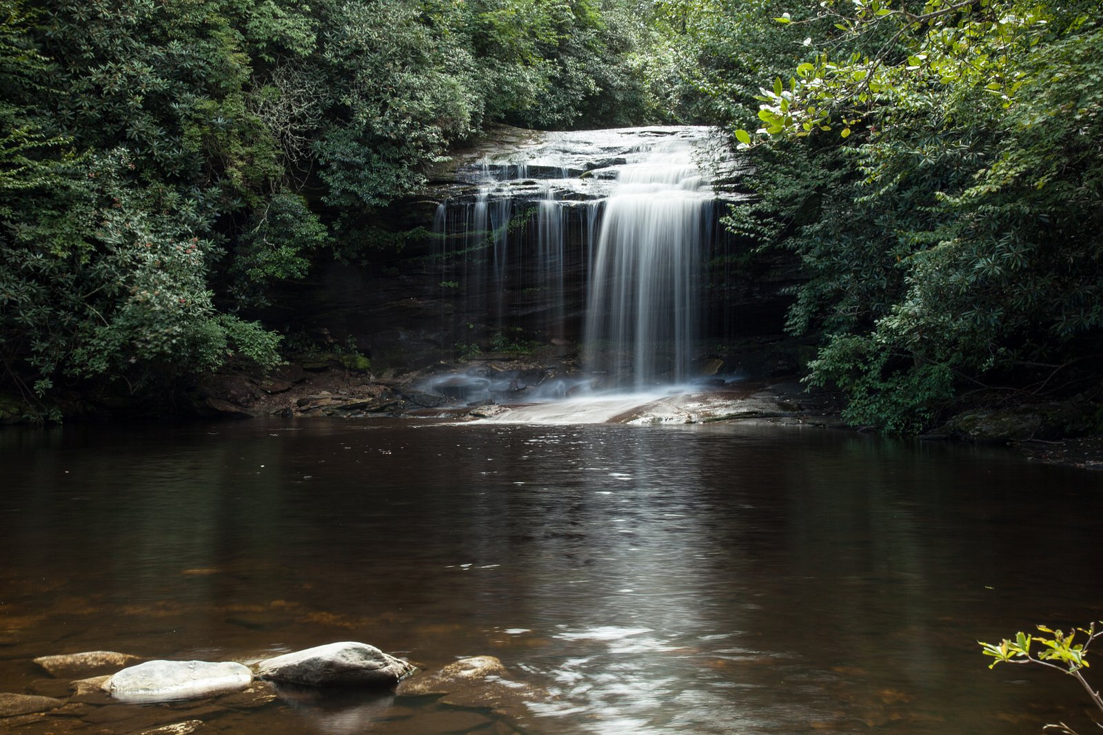
About Dismal Falls
Dismal Falls sits tucked into Pisgah National Forest and managed by the U.S. Forest Service, offering a quiet, photogenic cascade framed by mature forest. The falls are a favorite for hikers and photographers who appreciate a peaceful, woodsy setting rather than a developed attraction — it’s a place to slow down and listen to water and leaves. Access to the falls follows a modest forest route that rewards a short hike with scenic viewpoints; while there isn’t a widely published USFS trail number associated with the access in the provided data, the site’s location within Pisgah National Forest means the U.S. Forest Service oversees the surrounding land and any trail stewardship. Dismal Falls is best for visitors looking for an inviting natural stop on a day hike rather than a developed day-use area.
The Setting
Dismal Falls sits at 3,159 feet within Pisgah National Forest, fed by the French Broad River, in the mountains of North Carolina.
Nearby Falls Worth Visiting
Schoolhouse Falls (20 ft) lies 2.3 miles to the southwest.
Trail & Hike Details
The Approach
The moderate 2.4-mile out-and-back trail gains 350 feet of elevation on the way to the falls.
Trail Description
According to U.S. Forest Service data for the area, the approach to Dismal Falls is a 2.4-mile out-and-back route with approximately 350 feet of elevation gain and a difficulty rating of moderate. The available USFS information does not list a specific trail name or number for this access route, nor does it provide formal details on trail surface, grade, or technical class. Hikers should plan for a short, moderate hike and check with the local Pisgah National Forest ranger district for any updates or on-the-ground trail conditions before heading out.
What to Expect
Visitors can expect a tranquil natural setting with cascading waters. The area may be less crowded compared to other popular waterfalls.
Accessibility
The trail is not wheelchair accessible. Uneven terrain and elevation changes require steady footing.
Frequently Asked Questions
🐶 Are Dogs Allowed at Dismal Falls?
❌ Dogs are not allowed
Are There Any Fees or Permits Required?
🆖 No fees required
🏊 Is There Swimming at Dismal Falls?
❌ Swimming is not allowed
When to Visit
Spring and fall are typically the best times to visit due to pleasant weather and vibrant foliage.
Seasonal Access
The best time to visit is Spring, Summer, and Fall. Winter access may be limited. Check with Pisgah National Forest for seasonal road closures.
Safety Information
Exercise caution on uneven terrain and near the water. Check weather conditions before visiting.
Current Water Conditions
94 ft³/s
Current discharge — how much water is flowing
Lower than usual for this time of year
Based on 92 years of record
2.09 ft
Water depth at gauge
7-Day Discharge Trend
What does this mean for your visit?
Flow is lower than usual for this time of year.
About This Gauge
This gauge is on a nearby waterway and may not reflect exact conditions at the falls.
7-Day Flow Outlook
Based on the USGS gauge FRENCH BROAD RIVER AT ROSMAN, NC (14 km away).
Today
Moderate
108 cfs
4/10Tomorrow
Moderate
115 cfs
4/10Wed
Moderate
110 cfs
4/10Thu
Moderate
104 cfs
4/10Fri
Moderate
108 cfs
4/10Sat
Moderate
106 cfs
4/10Sun
Moderate
106 cfs
4/10Best window: Today — moderate flow, patchy fog then chance showers and thunderstorms (trip score 4/10).
Best time of year: this gauge typically runs highest from mid February to early May, peaking in March.
How we calculate this
This is a transparent outlook, not a precise forecast. We take the waterfall's current flow strength (how it ranks against its historical normal for today, from the nearest USGS stream gauge), carry that ranking forward along the gauge's seasonal curve, and nudge it for forecast rain. Confidence is highest for the next day or two and falls further out. Always check official conditions and your own judgment before visiting — high flows can be dangerous.
Know when to go.
Get a free email alert when waterfalls near Glenville hit peak flow. We only send when conditions are worth the trip — no weekly newsletters, no spam.
Weather Forecast
Location & Access
Getting There
The exact location of Dismal Falls in North Carolina is not well-documented. Visitors are advised to consult local maps or guides for directions.
Get Directions on Google MapsParking
Parking availability is unclear. Visitors should prepare for limited or roadside parking options.
Elevation
3,159 feet above sea level
Coordinates
35.182321° N, -82.972915° W
Land Management
Managed by USFS
Visitor Tips & Gear
Bring sturdy footwear and be prepared for uneven terrain. Check local conditions before visiting.
As an Amazon Associate, we earn from qualifying purchases.
With 2.4 miles and 350 ft of elevation gain, sturdy boots and trekking poles will help on this moderate trail. Sun exposure on the trail makes good sun protection a must in summer.

Polarized Sunglasses (Knockaround)
Cuts glare off the water so you actually see the falls — and your photos turn out better too.

Columbia Watertight II Rain Jacket
Packs into its own pocket, seam-sealed, and keeps you dry from spray and surprise rain.

Earth Pak Waterproof Dry Bag
Keeps your phone and gear dry when waterfall mist soaks everything else.

Waterproof Phone Pouch (AiRunTech)
Cheap insurance — take photos right next to the falls without killing your phone.

Timberland Euro Sprint Mid Waterproof
Trusted waterproof boot with premium leather and grippy rubber sole — reliable on rocky, wet trails.

TrailBuddy Trekking Poles
Lightweight aluminum, cork grips, and flip-locks that actually hold — a best-seller for good reason.
Where to Stay

Foxhunt at Sapphire Valley

Fairway Forest

The Lodge Nantahala River

The Wells Cashiers
Browse vacation cabins and private rentals nearby
Unique outdoor stays — tents, yurts, and treehouses
Rent a campervan or RV for your waterfall road trip
Some links are affiliate links. We may earn a commission at no extra cost to you.
Nearby Campground
BALSAM LAKE LODGE
6.4 miles away · 1 sites
Overview Balsam Lake Lodge is nestled in the center of the 39,000-acre Roy Taylor Forest within the Nantahala National Forest. The lodge overlooks Balsam Lake and offers spectacular mountain views.The lodge opened its doors to the public when the Forest Service acquired the dwelling and lake in 1982. Since then groups have rented the lodge for meetings, recreation and environmental activities. NOTE: Balsam Lake Lodge is not a campground and has no campsites available for sewer, water, or electric
Book on Recreation.govNearby Hot Springs
Hot springs near Glenville, North Carolina

Looking for a soak after your hike? Explore more hot springs near Glenville, North Carolina on SoakingSprings.
Explore North Carolina springsAdditional Information
Nearby Attractions
Explore other natural attractions in the area, such as hiking trails and scenic overlooks.
Wildlife
The area may feature local wildlife such as birds, deer, and small mammals.
Cities near Dismal Falls
Nearby Waterfalls
Writing about Dismal Falls? Embed this waterfall on your site for free.