

Photo Credits (5)
Difficulty
Moderate
Trail Length
2.4 miles
Trail Type
Out And Back
Elevation Gain
350 ft
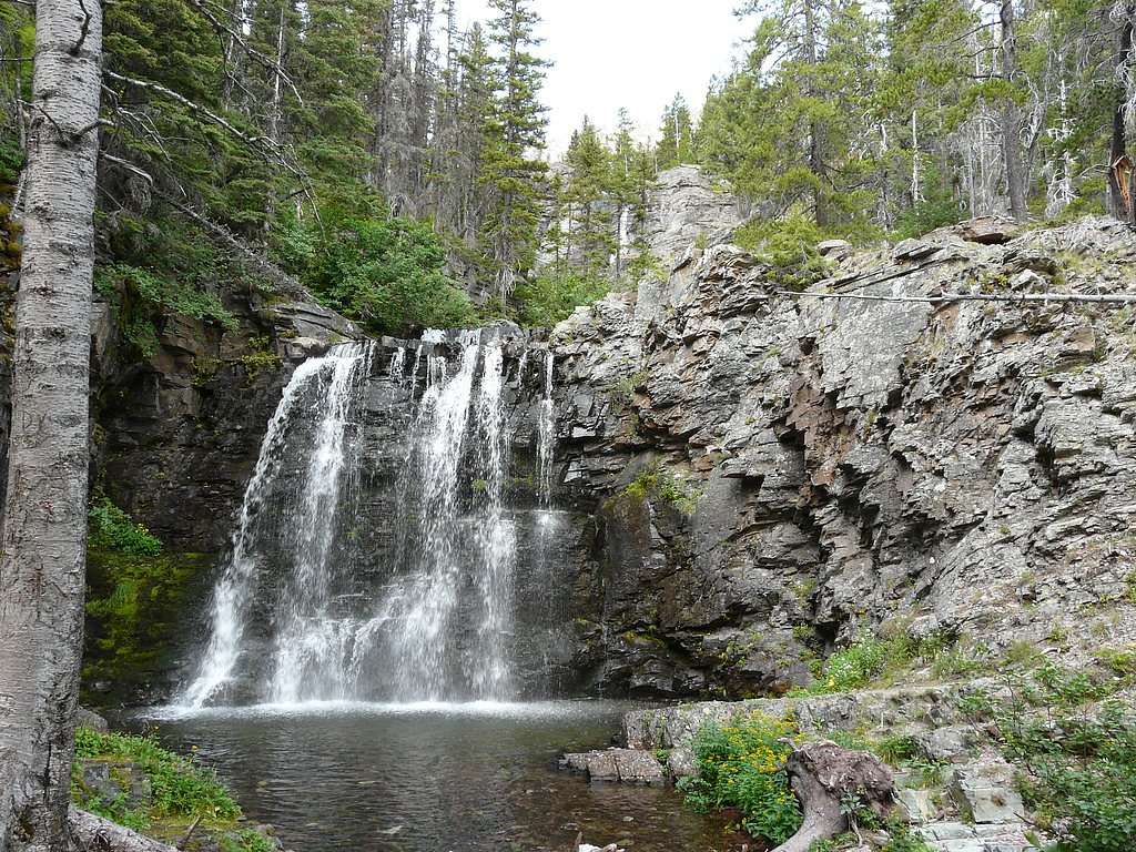
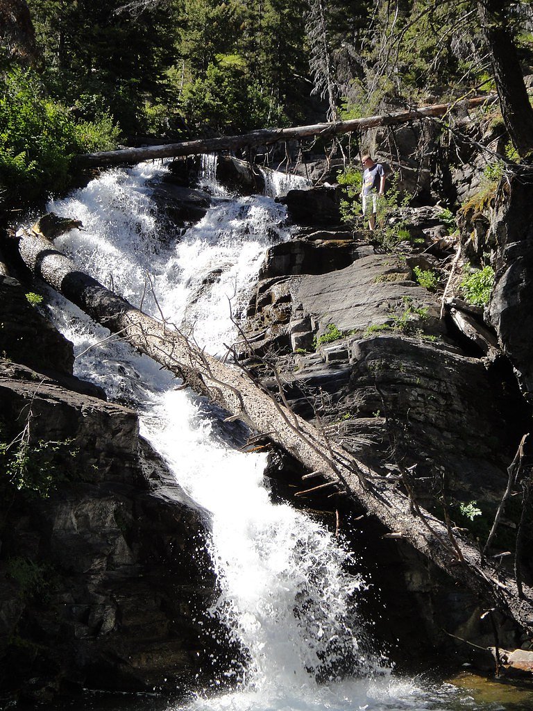
About Dawson Falls
Dawson Falls is a peaceful, photogenic cascade tucked away in Montana on land owned by DESG within the Blackfeet Indian Reservation. The setting invites quiet exploration and photography, and because the site lies on tribal land (designation: TRIB) it’s managed by the Blackfeet tribal authorities — visitors should respect local rules and any posted guidance while exploring the area. The falls are a rewarding short outing for hikers looking for a moderate walk with scenic payoff. The route to the viewpoint is commonly described as a short, forested approach that delivers the steady sound and sight of falling water without requiring advanced mountaineering skills, making Dawson Falls a great half-day destination for families and day hikers who want a tranquil stop on their Montana itinerary.
The Setting
Dawson Falls sits at 4,705 feet within Blackfeet Indian Reservation, fed by the Two Medicine River Bl South Fork, in the mountains of Montana.
Trail & Hike Details
The Approach
The moderate 2.4-mile out-and-back trail gains 350 feet of elevation on the way to the falls.
Trail Description
Trail to Dawson Falls is an out-and-back roughly 2.4 miles round trip with about 350 feet of elevation gain, rated moderate. The route follows a short forested approach and is commonly described as well-marked; hikers can expect a moderate-grade walk that reaches the waterfall and returns along the same alignment. No USFS trail number or surface/class data are provided for this route, and because the trail lies on tribal-managed land visitors should observe any local regulations and stay on the established path.
What to Expect
Dogs are welcome.
Accessibility
The trail is not wheelchair accessible. Uneven terrain and elevation changes require steady footing.
Frequently Asked Questions
🐶 Are Dogs Allowed at Dawson Falls?
✅ Dogs are allowed
Are There Any Fees or Permits Required?
🆖 No fees required
🏊 Is There Swimming at Dawson Falls?
❌ Swimming is not allowed
When to Visit
Spring and early summer are ideal times to visit Dawson Falls, as the water flow is typically at its peak due to snowmelt.
Seasonal Access
The best time to visit is Spring, Summer, and Fall. Winter access may be limited.
Safety Information
Be cautious of slippery rocks near the waterfall. Check weather and road conditions before visiting, as heavy rain or snow can make access difficult. Carry bear spray and be aware of wildlife in the area.
Current Water Conditions
415 ft³/s
Current discharge — how much water is flowing
About average for this time of year
Based on 48 years of record
3.22 ft
Water depth at gauge
7-Day Discharge Trend
What does this mean for your visit?
Flow is about average for this time of year.
About This Gauge
This gauge is on a nearby waterway and may not reflect exact conditions at the falls.
7-Day Flow Outlook
Based on the USGS gauge Two Medicine River bl South Fork nr Browning MT (16 km away).
Today
Low
448 cfs
4/10Tomorrow
Low
449 cfs
4/10Mon
Low
423 cfs
4/10Tue
Low
425 cfs
3/10Wed
Low
370 cfs
6/10Thu
Low
344 cfs
4/10Fri
Low
352 cfs
3/10Best window: Wed — low flow, mostly sunny (trip score 6/10).
Best time of year: this gauge typically runs highest from mid April to mid July, peaking in May.
How we calculate this
This is a transparent outlook, not a precise forecast. We take the waterfall's current flow strength (how it ranks against its historical normal for today, from the nearest USGS stream gauge), carry that ranking forward along the gauge's seasonal curve, and nudge it for forecast rain. Confidence is highest for the next day or two and falls further out. Always check official conditions and your own judgment before visiting — high flows can be dangerous.
Know when to go.
Get a free email alert when waterfalls near East Glacier Park Village hit peak flow. We only send when conditions are worth the trip — no weekly newsletters, no spam.
Weather Forecast
Location & Access
Getting There
Dawson Falls is located within the Kootenai National Forest. Visitors typically access the falls via forest roads, which may require a high-clearance vehicle depending on conditions. It is recommended to check with the local ranger station for the latest road and trail conditions.
Get Directions on Google MapsParking
There is a small parking area near the trailhead, but availability may be limited during peak seasons.
Elevation
4,705 feet above sea level
Coordinates
48.423343° N, -113.209172° W
Land Management
Managed by TRIB
Visitor Tips & Gear
Wear sturdy shoes as the trail may be muddy or slippery, especially after rain. Bring insect repellent during the summer months. Check road conditions before visiting, as forest roads can sometimes be rough or impassable.
As an Amazon Associate, we earn from qualifying purchases.
With 2.4 miles and 350 ft of elevation gain, sturdy boots and trekking poles will help on this moderate trail. Sun exposure on the trail makes good sun protection a must in summer.

Polarized Sunglasses (Knockaround)
Cuts glare off the water so you actually see the falls — and your photos turn out better too.

Columbia Watertight II Rain Jacket
Packs into its own pocket, seam-sealed, and keeps you dry from spray and surprise rain.

Earth Pak Waterproof Dry Bag
Keeps your phone and gear dry when waterfall mist soaks everything else.

Waterproof Phone Pouch (AiRunTech)
Cheap insurance — take photos right next to the falls without killing your phone.

Timberland Euro Sprint Mid Waterproof
Trusted waterproof boot with premium leather and grippy rubber sole — reliable on rocky, wet trails.

TrailBuddy Trekking Poles
Lightweight aluminum, cork grips, and flip-locks that actually hold — a best-seller for good reason.
Where to Stay

Circle R Motel

Glacier Alpine Lodges

Glacier Alpine Escape

Cedar Cabin Cozy 2-Bedroom next to Glacier Park
Browse vacation cabins and private rentals nearby
Unique outdoor stays — tents, yurts, and treehouses
Rent a campervan or RV for your waterfall road trip
Some links are affiliate links. We may earn a commission at no extra cost to you.
Nearby Campground
Two Medicine Campground
8.5 miles away · 105 sites
Overview Two Medicine is a 100 site campground located in the Two Medicine Valley of Glacier National Park. There is a ranger station and campstore in close proximity, but no other services or accommodations are located in the valley. There is no cell service or wifi. Generators are allowed only in Loops B & C. Generators are prohibited in Loop A. All sites require a reservation. Most sites have a 6-month booking window with a good handful having a 4-day booking window. For information on nearb
Book on Recreation.govAdditional Information
Nearby Attractions
Other attractions in the Kootenai National Forest include Kootenai Falls and Ross Creek Cedars Scenic Area.
Wildlife
The area is home to a variety of wildlife, including deer, birds, and occasionally bears. Visitors should practice bear safety and carry bear spray.
Cities near Dawson Falls
Nearby Waterfalls
Other waterfalls named Dawson Falls
1 other waterfall shares this name across the U.S.
Writing about Dawson Falls? Embed this waterfall on your site for free.