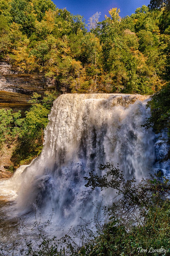
Cul-car-mac Falls
By Armen Suny · Last verified May 2026
Difficulty
Moderate
Trail Length
2.4 miles
Trail Type
Out And Back
Elevation Gain
350 ft
About Cul-car-mac Falls
Cul-car-mac Falls is a quiet, lesser-known waterfall tucked into Tennessee’s forested hills—a peaceful spot that rewards visitors looking to escape the crowds. The setting is intimate and scenic, with the falls framed by mature woods that make for pleasant photography, birdwatching, or a relaxed picnic near the water. Because it sees fewer visitors than more famous cascades, Cul-car-mac has a welcoming, backcountry feel that’s perfect for a reflective day hike. Access to the falls is via a relatively short trek: the route is an out-and-back of 2.4 miles with about 350 feet of elevation gain, making it a comfortable half-day outing for most hikers. If you want to make a weekend of it, Ragland Bottom Campground lies about 6.13 km from the falls and provides nearby overnight options and a base for exploring the area.
The Setting
Cul-car-mac Falls sits at 886 feet along the Smith Fork, in the foothills of Tennessee.
Trail & Hike Details
The Approach
The moderate 2.4-mile out-and-back trail gains 350 feet of elevation on the way to the falls.
Trail Description
Trail to Cul-car-mac Falls: 2.4 miles out-and-back with roughly 350 feet of cumulative elevation gain, typically rated moderate. Specific USFS trail surface, grade, and classification are not documented for this route; expect natural tread with the kinds of uneven footing common on forested hiking paths. Hikers should prepare for varying trail conditions, bring sturdy footwear and water, and consult local resources or land managers for current access or seasonal advisories. Ragland Bottom Campground is approximately 6.13 km away for anyone planning an overnight stay.
What to Expect
Expect a peaceful and scenic experience with a waterfall surrounded by natural beauty. The area may have uneven terrain and forested surroundings.
Accessibility
The trail is not wheelchair accessible. Uneven terrain and elevation changes require steady footing.
Frequently Asked Questions
🐶 Are Dogs Allowed at Cul-car-mac Falls?
❌ Dogs are not allowed
Are There Any Fees or Permits Required?
🆖 No fees required
🏊 Is There Swimming at Cul-car-mac Falls?
❌ Swimming is not allowed
When to Visit
Spring and fall are typically the best times to visit, as the waterfall may have higher flow due to seasonal rains.
Seasonal Access
The best time to visit is Spring, Summer, and Fall. Winter access may be limited.
Safety Information
Trail conditions are not well-documented, so visitors should exercise caution. Be prepared for uneven terrain, potential wildlife encounters, and changing weather conditions.
Current Water Conditions
13 ft³/s
Current discharge — how much water is flowing
Much lower than usual for this time of year
Based on 34 years of record
2.59 ft
Water depth at gauge
7-Day Discharge Trend
What does this mean for your visit?
Flow is well below normal for this time of year, so the waterfall may be a trickle.
About This Gauge
This gauge is on a nearby waterway and may not reflect exact conditions at the falls.
7-Day Flow Outlook
Based on the USGS gauge SMITH FORK AT TEMPERANCE HALL, TN (20 km away).
Today
Moderate
15 cfs
4/10Tomorrow
Moderate
21 cfs
4/10Tue
Moderate
19 cfs
4/10Wed
Moderate
16 cfs
4/10Thu
Moderate
14 cfs
4/10Fri
Moderate
19 cfs
4/10Sat
Moderate
16 cfs
4/10Best window: Today — moderate flow, chance showers and thunderstorms (trip score 4/10).
Best time of year: this gauge typically runs highest from mid February to late March, peaking in March.
How we calculate this
This is a transparent outlook, not a precise forecast. We take the waterfall's current flow strength (how it ranks against its historical normal for today, from the nearest USGS stream gauge), carry that ranking forward along the gauge's seasonal curve, and nudge it for forecast rain. Confidence is highest for the next day or two and falls further out. Always check official conditions and your own judgment before visiting — high flows can be dangerous.
Know when to go.
Get a free email alert when waterfalls near Smithville hit peak flow. We only send when conditions are worth the trip — no weekly newsletters, no spam.
Weather Forecast
Location & Access
Getting There
The exact location of Cul-car-mac Falls is not widely documented. Visitors are advised to consult local hiking guides or park services for directions.
Get Directions on Google MapsParking
Parking availability is unclear. Visitors should plan ahead and check with local resources for parking options near the trailhead.
Elevation
886 feet above sea level
Coordinates
35.945064° N, -85.776095° W
Visitor Tips & Gear
Bring sturdy footwear, as trail conditions are not well-documented. Check weather conditions before visiting and carry sufficient water and snacks.
As an Amazon Associate, we earn from qualifying purchases.
With 2.4 miles and 350 ft of elevation gain, sturdy boots and trekking poles will help on this moderate trail. Sun exposure on the trail makes good sun protection a must in summer.

Columbia Watertight II Rain Jacket
Packs into its own pocket, seam-sealed, and keeps you dry from spray and surprise rain.

Earth Pak Waterproof Dry Bag
Keeps your phone and gear dry when waterfall mist soaks everything else.

Waterproof Phone Pouch (AiRunTech)
Cheap insurance — take photos right next to the falls without killing your phone.

Timberland Euro Sprint Mid Waterproof
Trusted waterproof boot with premium leather and grippy rubber sole — reliable on rocky, wet trails.

TrailBuddy Trekking Poles
Lightweight aluminum, cork grips, and flip-locks that actually hold — a best-seller for good reason.

Polarized Sunglasses (Knockaround)
Cuts glare off the water so you actually see the falls — and your photos turn out better too.
Where to Stay

Hampton Inn Mcminnville, Tn

Country Inn & Suites by Radisson, Cookeville, TN

stayAPT Suites Lebanon-Nashville Area

La Quinta by Wyndham Lebanon
Browse vacation cabins and private rentals nearby
Unique outdoor stays — tents, yurts, and treehouses
Rent a campervan or RV for your waterfall road trip
Some links are affiliate links. We may earn a commission at no extra cost to you.
Nearby Campground
RAGLAND BOTTOM
3.8 miles away · 57 sites
Overview Ragland Bottom Campground is located on the shores of the scenic Center Hill Lake on central Tennessee's Highland Rim. The lake stretches 64 miles up the Caney Fork River, where visitors come to enjoy boating, fishing and water sports. The 415 miles of forested shoreline provide excellent hiking, hunting and camping opportunities. 2025 Events: The annual Halloween event will be held Saturday, October 25, 2025. Recreation Boating, waterskiing, canoeing and fishing are popular activities
Book on Recreation.govAdditional Information
Nearby Attractions
Nearby attractions are not well-documented. Visitors may explore other natural areas in Tennessee.
Wildlife
The area may feature typical Tennessee wildlife, including birds, deer, and small mammals. Be cautious of snakes and other potentially hazardous wildlife.
Cities near Cul-car-mac Falls
Nearby Waterfalls
Writing about Cul-car-mac Falls? Embed this waterfall on your site for free.