Difficulty
Moderate
Trail Length
2.4 miles
Trail Type
Out And Back
Elevation Gain
350 ft
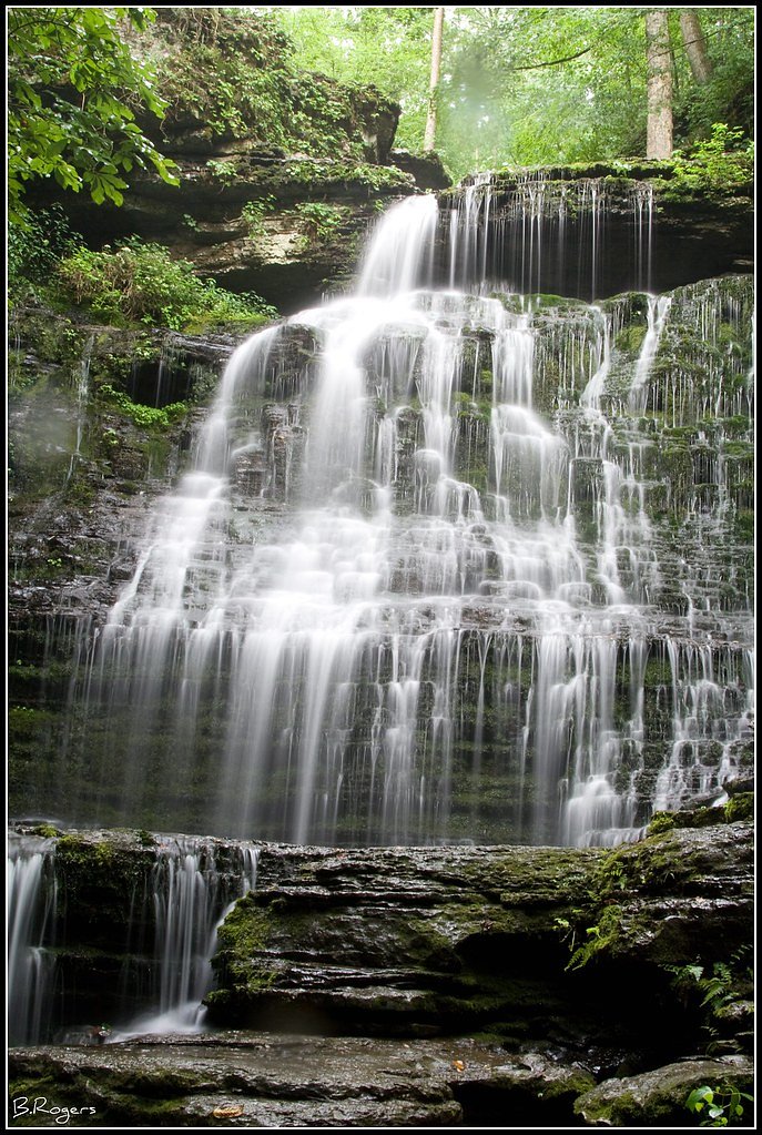
About Copperas Falls
Copperas Falls is a small but picturesque waterfall located near Tullahoma, Tennessee. It is a hidden gem in the area, surrounded by lush greenery and offering a serene escape for visitors. The waterfall is part of a creek system and may have varying water flow depending on recent rainfall.
The Setting
Copperas Falls sits at 948 feet along the Duck River, in the foothills of Tennessee.
Trail & Hike Details
The Approach
The moderate 2.4-mile out-and-back trail gains 350 feet of elevation on the way to the falls.
Trail Description
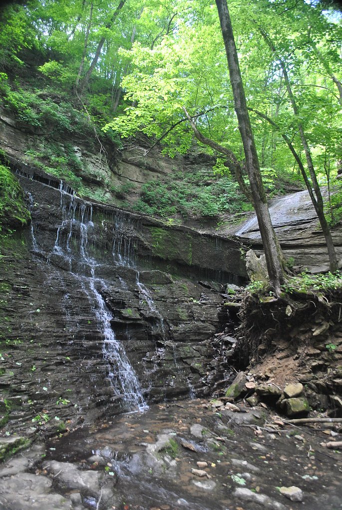
The trail to Copperas Falls is a short and relatively easy hike through a wooded area. The path may be uneven in places, with some roots and rocks, but it is generally manageable for most visitors. The trail follows a creek, adding to the scenic beauty of the hike.
What to Expect
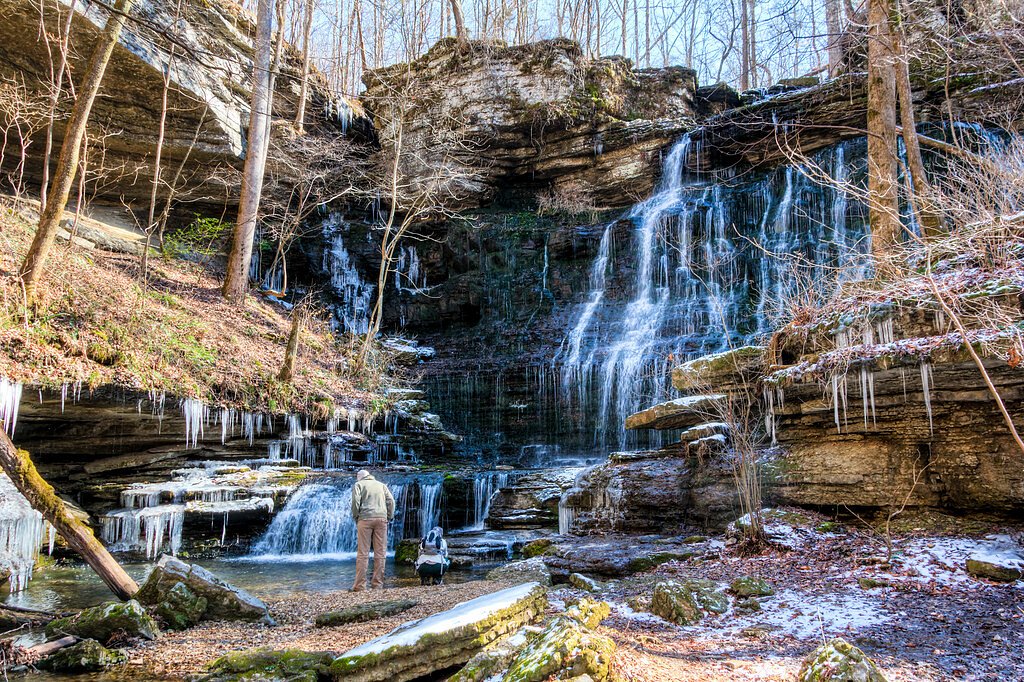
Visitors can expect a peaceful and scenic hike leading to a small waterfall surrounded by natural beauty. The water flow may vary depending on recent rainfall, so the falls may be more impressive after a period of rain.
Accessibility
The trail is not wheelchair accessible. Uneven terrain and elevation changes require steady footing.
Frequently Asked Questions
🐶 Are Dogs Allowed at Copperas Falls?
❌ Dogs are not allowed
Are There Any Fees or Permits Required?
🆖 No fees required
🏊 Is There Swimming at Copperas Falls?
❌ Swimming is not allowed
When to Visit
Spring and early summer are the best times to visit, as the water flow is typically stronger during these seasons. Fall offers beautiful foliage, while winter may provide a quieter experience.
Seasonal Access
The best time to visit is Spring, Summer, and Fall. Winter access may be limited.
Safety Information
Be cautious of slippery rocks near the waterfall and along the creek. Avoid visiting during heavy rain or immediately after storms, as the trail may become muddy and the creek may swell.
Current Water Conditions
37 ft³/s
Current discharge — how much water is flowing
About average for this time of year
Based on 77 years of record
0.25 ft
Water depth at gauge
7-Day Discharge Trend
What does this mean for your visit?
Flow is about average for this time of year.
About This Gauge
This gauge is on a nearby waterway and may not reflect exact conditions at the falls.
7-Day Flow Outlook
Based on the USGS gauge DUCK RIVER BELOW MANCHESTER, TN (11 km away).
Today
Moderate
42 cfs
6/10Tomorrow
Moderate
41 cfs
6/10Tue
Moderate
41 cfs
6/10Wed
Moderate
44 cfs
6/10Thu
Moderate
44 cfs
6/10Fri
Moderate
42 cfs
6/10Sat
Moderate
40 cfs
6/10Best window: Today — moderate flow, chance showers and thunderstorms (trip score 6/10).
Best time of year: this gauge typically runs highest from early February to late March, peaking in March.
How we calculate this
This is a transparent outlook, not a precise forecast. We take the waterfall's current flow strength (how it ranks against its historical normal for today, from the nearest USGS stream gauge), carry that ranking forward along the gauge's seasonal curve, and nudge it for forecast rain. Confidence is highest for the next day or two and falls further out. Always check official conditions and your own judgment before visiting — high flows can be dangerous.
Know when to go.
Get a free email alert when waterfalls near Tullahoma hit peak flow. We only send when conditions are worth the trip — no weekly newsletters, no spam.
Weather Forecast
Location & Access
Getting There
Copperas Falls is located near Tullahoma, Tennessee, approximately 2.5 miles from the town center. The coordinates for the falls are 35.4201, -86.2214. Access to the falls typically involves a short hike through wooded terrain.
Get Directions on Google MapsParking
Parking availability is limited and may be informal. Visitors should look for safe spots to park near the trailhead, but be cautious not to block private property or roadways.
Elevation
948 feet above sea level
Coordinates
35.420077° N, -86.221380° W
Visitor Tips & Gear
Wear sturdy shoes as the trail may be uneven in places. Bring insect repellent, especially in warmer months, as the area can have mosquitoes. Visit after recent rainfall for the best waterfall flow.
As an Amazon Associate, we earn from qualifying purchases.
With 2.4 miles and 350 ft of elevation gain, sturdy boots and trekking poles will help on this moderate trail. Sun exposure on the trail makes good sun protection a must in summer.

Columbia Watertight II Rain Jacket
Packs into its own pocket, seam-sealed, and keeps you dry from spray and surprise rain.

Earth Pak Waterproof Dry Bag
Keeps your phone and gear dry when waterfall mist soaks everything else.

Waterproof Phone Pouch (AiRunTech)
Cheap insurance — take photos right next to the falls without killing your phone.

Timberland Euro Sprint Mid Waterproof
Trusted waterproof boot with premium leather and grippy rubber sole — reliable on rocky, wet trails.

TrailBuddy Trekking Poles
Lightweight aluminum, cork grips, and flip-locks that actually hold — a best-seller for good reason.

Polarized Sunglasses (Knockaround)
Cuts glare off the water so you actually see the falls — and your photos turn out better too.
Where to Stay

LivSmart Studios By Hilton Tullahoma

Holiday Inn Express - Tullahoma by IHG

Comfort Suites Manchester near Arnold AFB

TownePlace Suites by Marriott Tullahoma
Browse vacation cabins and private rentals nearby
Unique outdoor stays — tents, yurts, and treehouses
Rent a campervan or RV for your waterfall road trip
Some links are affiliate links. We may earn a commission at no extra cost to you.
Additional Information
Nearby Attractions
Nearby attractions include Normandy Lake, Old Stone Fort State Archaeological Park, and the town of Tullahoma.
Wildlife
The area is home to various birds, small mammals, and insects. Visitors may also encounter frogs and other creek-dwelling creatures.
Cities near Copperas Falls
Nearby Waterfalls
Other waterfalls named Copperas Falls
1 other waterfall shares this name across the U.S.
Writing about Copperas Falls? Embed this waterfall on your site for free.