Difficulty
Moderate
Trail Length
2.4 miles
Trail Type
Out And Back
Elevation Gain
350 ft
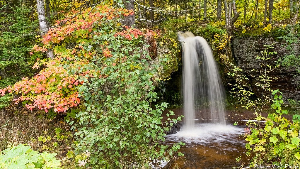
About Cole Creek Falls
Cole Creek Falls is a small, scenic cascade tucked into Michigan’s Upper Peninsula where Cole Creek feeds into the Escanaba River watershed. The falls lie within Hiawatha National Forest and are managed by the U.S. Forest Service, making this a quietly preserved and remote stop for hikers who prefer a low-key waterfall experience. The approach follows the AUTRAIN SONGBIRD INTERP route (Trail #311A), winding through native forest that lends a peaceful, backcountry feel to the visit. Reaching the falls is a pleasant half-day outing: the route to Cole Creek Falls is roughly a 2.4-mile out-and-back with about 350 feet of elevation gain, so you’ll pass through gentle grades and natural tread before arriving at the picturesque creekside. The setting is ideal for photographers and hikers looking for a short, moderate trek through typical Upper Peninsula forest without heavy crowds.
The Setting
Cole Creek Falls sits at 666 feet within Hiawatha National Forest, in the foothills of Michigan.
Nearby Falls Worth Visiting
Alger Falls (15 ft) lies 8.0 miles to the east. Also nearby: Rock River Falls (15 ft, 7.7 mi) and Scott Falls (10 ft, 2.6 mi).
Trail & Hike Details
The Approach
The moderate hike follows Autrain Songbird Interp (#311A), a 2.4-mile out-and-back trail over natural surface. Expect 350 feet of elevation gain with grades of 0-5%. The trail is developed (Class 3).
USFS Trail
AUTRAIN SONGBIRD INTERP #311A
Trail Class
Developed
Surface
Avg Grade
USFS Segment
2.03 miTrail Description
Trail: AUTRAIN SONGBIRD INTERP (USFS Trail #311A). Distance & type: Approximately 2.4 miles out-and-back (USFS GIS records ~2.03 miles of designated trail). Elevation gain: ~350 feet. Difficulty: Moderate. Surface & technical: Trail surface is native material and the route includes Class 3 sections; typical grade is 0–5%. Expect largely gentle slopes but uneven footing in places and occasional muddy patches after rain. The trail is an out-and-back on natural tread managed by the U.S. Forest Service within Hiawatha National Forest, suitable for hikers comfortable with unpaved surfaces and some short, steeper segments.
What to Expect
Dogs are welcome.
Accessibility
The trail is not wheelchair accessible. Uneven terrain and elevation changes require steady footing.
Frequently Asked Questions
🐶 Are Dogs Allowed at Cole Creek Falls?
✅ Dogs are allowed
Are There Any Fees or Permits Required?
🆖 No fees required
🏊 Is There Swimming at Cole Creek Falls?
❌ Swimming is not allowed
When to Visit
Spring is the best time to visit, as the water flow is typically strongest due to snowmelt. Summer and fall also offer pleasant conditions, with fall providing beautiful foliage.
Seasonal Access
The best time to visit is Spring, Summer, and Fall. Winter access may be limited. Check with Hiawatha National Forest for seasonal road closures.
Safety Information
Visitors should exercise caution on the trail, as it may be slippery or muddy. Be aware of changing weather conditions and ensure you have a reliable way to navigate back to your vehicle.
Know when to go.
Get a free email alert when waterfalls near Chatham hit peak flow. We only send when conditions are worth the trip — no weekly newsletters, no spam.
Weather Forecast
Location & Access
Getting There
Cole Creek Falls is located near Gwinn, Michigan, in Marquette County. Access typically involves driving on forest roads, and the exact route may vary depending on current road conditions. Visitors should consult local maps or GPS for the most accurate directions.
Get Directions on Google MapsParking
Parking is limited and may involve roadside parking near the trailhead or access point. Visitors should ensure they are not blocking any roads or private property.
Elevation
666 feet above sea level
Coordinates
46.398611° N, -86.815833° W
Land Management
Managed by USFS
Visitor Tips & Gear
Wear sturdy shoes, as the trail may be muddy or uneven. Bring bug spray during the summer months to protect against mosquitoes. Check local conditions before visiting, as forest roads may be difficult to navigate after heavy rain or snow.
As an Amazon Associate, we earn from qualifying purchases.
With 2.4 miles and 350 ft of elevation gain, sturdy boots and trekking poles will help on this moderate trail. Sun exposure on the trail makes good sun protection a must in summer.

Columbia Watertight II Rain Jacket
Packs into its own pocket, seam-sealed, and keeps you dry from spray and surprise rain.

Earth Pak Waterproof Dry Bag
Keeps your phone and gear dry when waterfall mist soaks everything else.

Waterproof Phone Pouch (AiRunTech)
Cheap insurance — take photos right next to the falls without killing your phone.

Timberland Euro Sprint Mid Waterproof
Trusted waterproof boot with premium leather and grippy rubber sole — reliable on rocky, wet trails.

TrailBuddy Trekking Poles
Lightweight aluminum, cork grips, and flip-locks that actually hold — a best-seller for good reason.

Polarized Sunglasses (Knockaround)
Cuts glare off the water so you actually see the falls — and your photos turn out better too.
Where to Stay

Roam Inn

Comfort Inn & Suites Munising-Lakefront

Scotty's Motel

cabin 2
Browse vacation cabins and private rentals nearby
Unique outdoor stays — tents, yurts, and treehouses
Rent a campervan or RV for your waterfall road trip
Some links are affiliate links. We may earn a commission at no extra cost to you.
Nearby Campground
Grand Island National Recreation Area
7.9 miles away · 0 sites
Bring the family and check out Grand Island National Recreation Area!Grand Island is located in Lake Superior, about one-half mile from the mainland community of Munising, Michigan. Munising is about 43 miles from Marquette and 55 miles from Manistique. Grand Island is the perfect place to spend a day or even just a few hours biking and exploring. The island’s breathtaking overlooks, pristine sandy beaches, fascinating cultural sites, deep hard woods, and inland lakes make it an exciting and secl
Book on Recreation.govAdditional Information
Nearby Attractions
Nearby attractions include the Escanaba River and other waterfalls in the Upper Peninsula, such as Dead River Falls and Yellow Dog Falls.
Wildlife
The area is home to a variety of wildlife, including deer, birds, and small mammals. Visitors should be cautious of ticks and other insects.
Cities near Cole Creek Falls
Nearby Waterfalls

Writing about Cole Creek Falls? Embed this waterfall on your site for free.