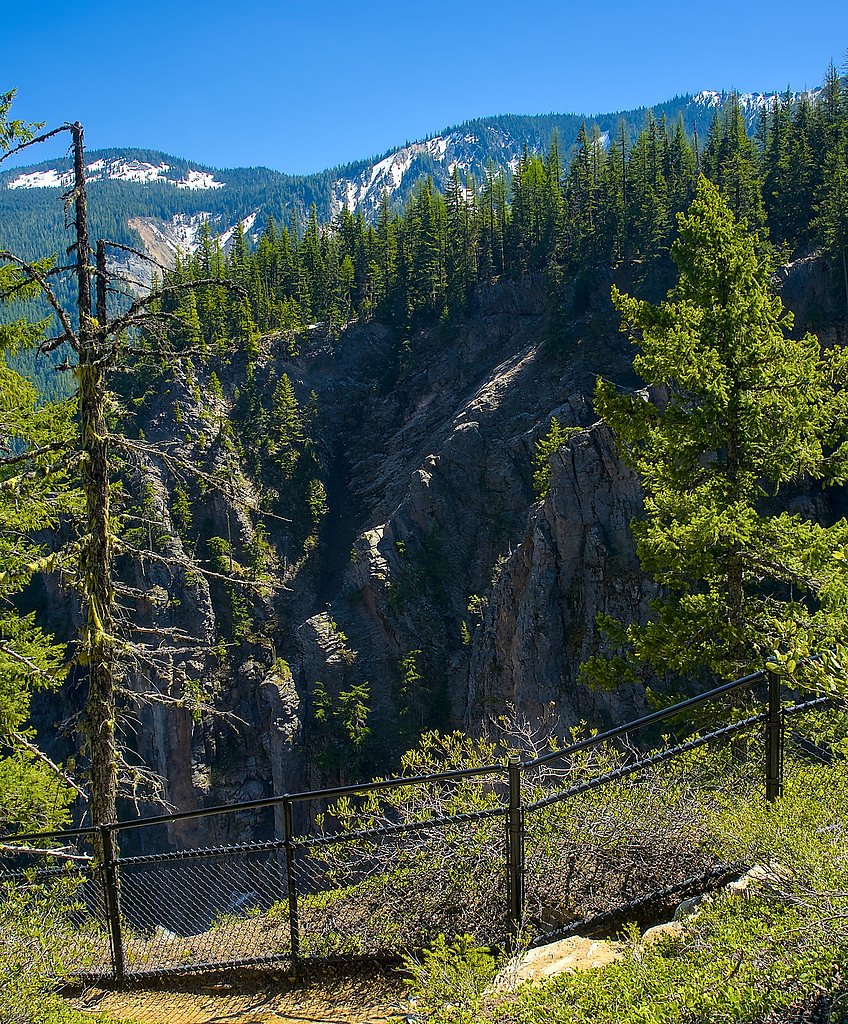
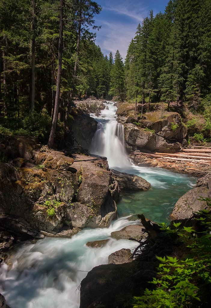
Clear Creek Falls
Washington • 300 ft
By Armen Suny · Last verified Mar 2026
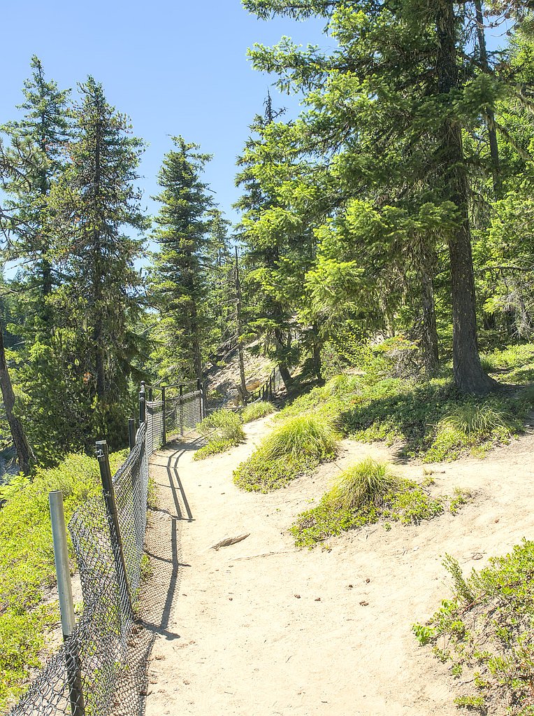
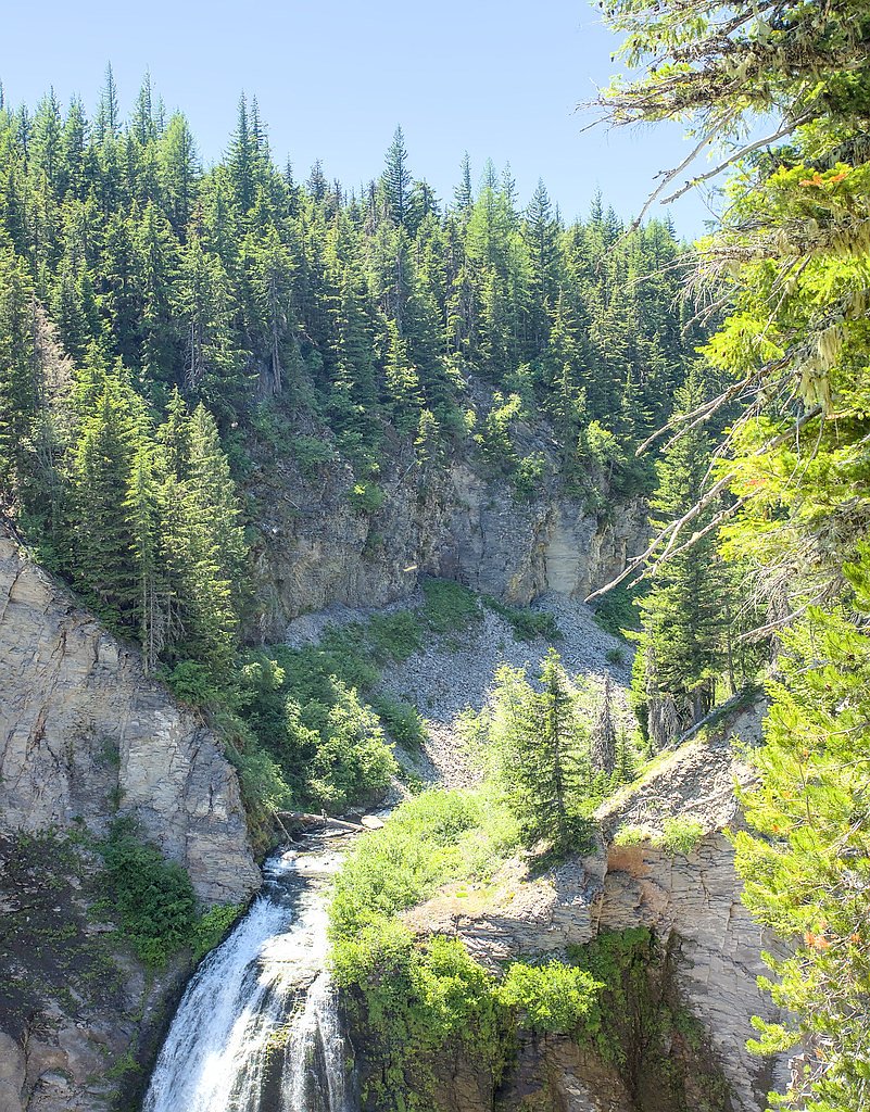
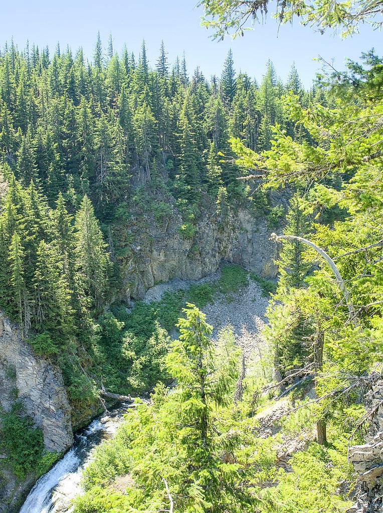
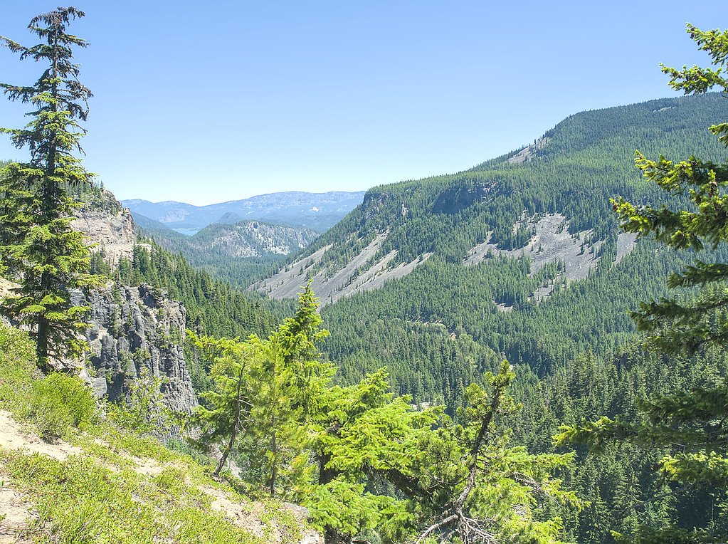

Photo Credits (5)
Difficulty
Moderate
Trail Length
2.4 miles
Trail Type
Out And Back
Elevation Gain
350 ft
About Clear Creek Falls
Clear Creek Falls is a dramatic 300-foot cascade that plunges into a deep canyon near Rimrock Lake, offering a spectacular scene for photographers and day hikers. Nestled within the Snoqualmie National Forest and managed by the U.S. Forest Service, the falls present a rugged, photogenic vista framed by classic Pacific Northwest forest and basalt walls. The viewpoint delivers sweeping views that make the short trip well worth the effort for anyone exploring the area. Access to the falls is most commonly made via the USFS Dark Meadows Trail (Trail #1107), which leads to the main overlook and several photo-friendly vantage points. The route also pairs nicely with camping nearby—White Pass Lake (Leech Lake) Campground is approximately 2.85 km from the falls—making Clear Creek Falls a convenient stop for an overnight trip or a longer loop through the Snoqualmie National Forest.
The Setting
Clear Creek Falls sits at 3,976 feet within Snoqualmie National Forest, fed by the Cowlitz River, in the mountains of Washington. At 300 feet, it is among the taller waterfalls in Washington.
Height: 300 feet
Trail & Hike Details
The Approach
The moderate hike follows Dark Meadows (#1107), a 2.4-mile out-and-back trail over n/a. Expect 350 feet of elevation gain with grades of N/A.
USFS Trail
DARK MEADOWS #1107
Trail Class
Class 0
Surface
Avg Grade
USFS Segment
1.73 miTrail Description
The hike to Clear Creek Falls is typically done as a moderate, out-and-back route of about 2.4 miles total with roughly 350 feet of elevation gain. Expect a moderate difficulty level and a short climb to reach the primary viewpoint of the 300-foot waterfall; the route is popular for day hikes and photography stops. Official USFS records list the approach as DARK MEADOWS, Trail #1107 (Class: N). The Forest Service entry records a GIS length of 1.73 miles for Trail #1107; surface and typical grade are not recorded (Surface: N/A, Typical grade: N/A), so trail conditions can vary and hikers should be prepared for unrecorded tread conditions. The route is out-and-back in type; plan accordingly and consider the nearby White Pass Lake (Leech Lake) Campground if you intend to overnight close to the trailhead.
What to Expect
The falls plunge 300 feet. Dogs are welcome.
Accessibility
The trail is not wheelchair accessible. Uneven terrain and elevation changes require steady footing.
Frequently Asked Questions
🐶 Are Dogs Allowed at Clear Creek Falls?
✅ Dogs are allowed
Are There Any Fees or Permits Required?
🆖 No fees required
🏊 Is There Swimming at Clear Creek Falls?
❌ Swimming is not allowed
When to Visit
Spring and early summer are the best times to visit, as the waterfall is most impressive during periods of high water flow.
Seasonal Access
The best time to visit is Spring, Summer, and Fall. Winter access may be limited. Check with Snoqualmie National Forest for seasonal road closures.
Safety Information
Stay on designated paths and avoid getting too close to the edge of the canyon. The area can be slippery, especially during wet or icy conditions.
Current Water Conditions
Based on a USGS gauge 15.9 miles away
1,070 ft³/s
Current discharge — how much water is flowing
Much lower than usual for this time of year
Based on 96 years of record
1.55 ft
Water depth at gauge
7-Day Discharge Trend
What does this mean for your visit?
Flow is well below normal for this time of year, so the waterfall may be a trickle.
About This Gauge
This gauge is on a regional waterway. Conditions at the falls may differ, especially after local rain.
7-Day Flow Outlook
Based on the USGS gauge COWLITZ RIVER AT PACKWOOD, WA (26 km away).
Today
Barely Flowing
1070 cfs
4/10Tomorrow
Low
1146 cfs
4/10Sun
Low
1119 cfs
4/10Mon
Low
1084 cfs
4/10Tue
Low
1074 cfs
4/10Wed
Low
1079 cfs
4/10Thu
Low
1024 cfs
4/10Best window: Today — barely flowing flow, mostly cloudy (trip score 4/10).
Best time of year: this gauge typically runs highest from mid April to mid July, peaking in June.
How we calculate this
This is a transparent outlook, not a precise forecast. We take the waterfall's current flow strength (how it ranks against its historical normal for today, from the nearest USGS stream gauge), carry that ranking forward along the gauge's seasonal curve, and nudge it for forecast rain. Confidence is highest for the next day or two and falls further out. Always check official conditions and your own judgment before visiting — high flows can be dangerous.
Know when to go.
Get a free email alert when waterfalls near Packwood hit peak flow. We only send when conditions are worth the trip — no weekly newsletters, no spam.
Weather Forecast
Location & Access
Getting There
Clear Creek Falls is located off U.S. Highway 12 near Rimrock Lake, approximately 40 miles west of Yakima, Washington. The falls can be accessed via a short drive from the highway.
Get Directions on Google MapsParking
There is a designated parking area near the Clear Creek Falls viewpoint, which is easily accessible from the highway.
Elevation
3,976 feet above sea level
Coordinates
46.656197° N, -121.350625° W
Land Management
Managed by USFS
Visitor Tips & Gear
Visit during the spring or early summer when water flow is at its peak. Bring a camera to capture the stunning views. Be cautious near the edges of the viewpoint, as the canyon is steep.
As an Amazon Associate, we earn from qualifying purchases.
With 2.4 miles and 350 ft of elevation gain, sturdy boots and trekking poles will help on this moderate trail. Sun exposure on the trail makes good sun protection a must in summer.

Polarized Sunglasses (Knockaround)
Cuts glare off the water so you actually see the falls — and your photos turn out better too.

Columbia Watertight II Rain Jacket
Packs into its own pocket, seam-sealed, and keeps you dry from spray and surprise rain.

Earth Pak Waterproof Dry Bag
Keeps your phone and gear dry when waterfall mist soaks everything else.

Waterproof Phone Pouch (AiRunTech)
Cheap insurance — take photos right next to the falls without killing your phone.

Timberland Euro Sprint Mid Waterproof
Trusted waterproof boot with premium leather and grippy rubber sole — reliable on rocky, wet trails.

TrailBuddy Trekking Poles
Lightweight aluminum, cork grips, and flip-locks that actually hold — a best-seller for good reason.
Where to Stay

Lafa Cabin - Luxe A Frame Retreat with Hot Tub, Sauna, Firepit- 5 Min to Mt Rainier

Packwood Lodge & Cabins

Tall Timber

Daffodil Cottage in Downtown Packwood, WIFI, BBQ, Firepit, Smores
Browse vacation cabins and private rentals nearby
Unique outdoor stays — tents, yurts, and treehouses
Rent a campervan or RV for your waterfall road trip
Some links are affiliate links. We may earn a commission at no extra cost to you.
Nearby Campground
White Pass Lake (Leech Lake) Campground
1.8 miles away · 0 sites
Located on the northeastern shores of Leech Lake, this site also offers trailhead access to the Pacific Crest Trail.
Book on Recreation.govNearby Hot Springs
Hot springs near Packwood, Washington

Ohanapecosh Hot Springs
Ohanapecosh Hot Springs flows at 122 degrees within Mount Rainier National Park at 1,920 feet elevation, emerging 74.5 degrees ...
Packwood Hot Spring
Packwood Hot Spring flows at 100 degrees at 1,002 feet elevation in the lower Cascade foothills near Morton, emerging 49.8 degr...

Longmire Mineral Springs
Longmire Mineral Springs flows at 77 degrees within Mount Rainier National Park at 2,758 feet elevation, emerging 31.9 degrees ...
Orr Creek Warm Springs
Orr Creek Warm Springs emerges at 72 degrees in the Gifford Pinchot National Forest at 2,910 feet elevation, flowing 26.5 degre...
Simcoe Soda Springs
Simcoe Soda Springs flows at 90 degrees Fahrenheit on Yakama Nation Reservation tribal land in Yakima County near Tieton, with ...

Mt Rainier Fumaroles
Mount Rainier fumaroles reach 162 degrees at 14,217 feet elevation, emerging 154.8 degrees above ambient at Washington's highes...
Looking for a soak after your hike? Explore more hot springs near Packwood, Washington on SoakingSprings.
Explore Washington springsAdditional Information
Nearby Attractions
Rimrock Lake, White Pass Scenic Byway, and Mount Rainier National Park.
Wildlife
The area around Clear Creek Falls is home to various wildlife, including deer, birds, and small mammals.
Cities near Clear Creek Falls
Nearby Waterfalls
Other waterfalls named Clear Creek Falls
1 other waterfall shares this name across the U.S.
Writing about Clear Creek Falls? Embed this waterfall on your site for free.