Photo Credits (5)
Difficulty
Hard
Trail Length
30.0 miles
Trail Type
Out And Back
Elevation Gain
6 ft
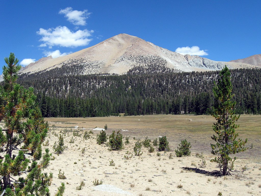
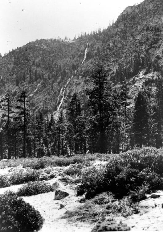
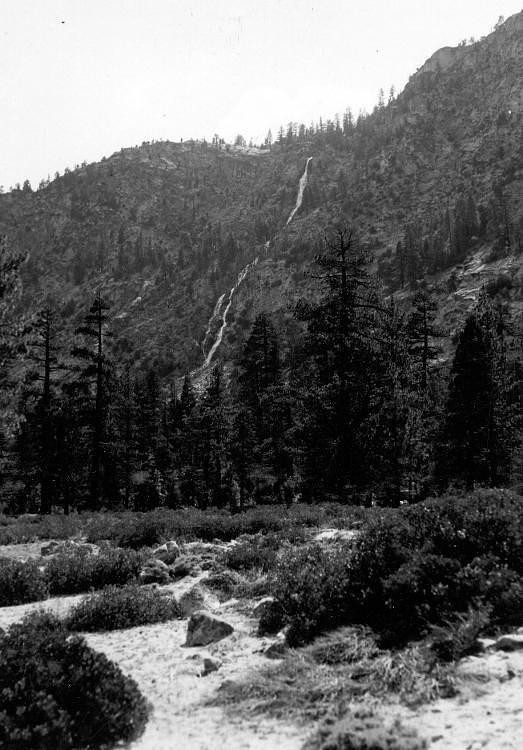
About Chagoopa Falls
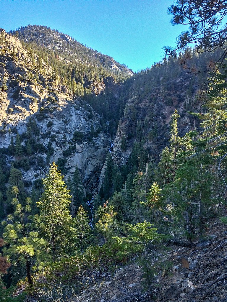
Chagoopa Falls is a remote and relatively inaccessible waterfall located in Sequoia National Park, California. It is known for its rugged beauty and is situated in the Kern River Canyon. Due to its remote location, it is rarely visited and requires significant effort to reach.
The Setting
Chagoopa Falls sits at 7,001 feet within Sequoia National Park, fed by the Marble Fork Kaweah R, in the high mountains of California.
Trail & Hike Details
The Approach
The hard 30.0-mile out-and-back trail gains 6 feet of elevation on the way to the falls.
Trail Description
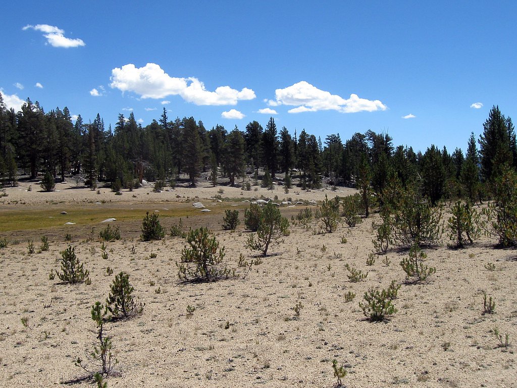
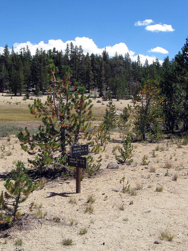
The trail to Chagoopa Falls follows the High Sierra Trail, a challenging and scenic route through Sequoia National Park. Hikers will traverse diverse terrain, including dense forests, alpine meadows, and steep canyon walls. The final approach to the falls may require off-trail navigation and careful planning.
What to Expect
Visitors can expect a remote and pristine wilderness experience. The falls are located in a rugged canyon and may have varying water flow depending on the season. The journey to the falls is strenuous and requires proper preparation, including navigation skills and backcountry permits.
Accessibility
The trail involves steep, uneven terrain with significant elevation change and is not accessible to mobility devices.
Frequently Asked Questions
🐶 Are Dogs Allowed at Chagoopa Falls?
❌ Dogs are not allowed
Are There Any Fees or Permits Required?
🤑 Fee: $35.00
Permit required
A wilderness permit is required for overnight trips in Sequoia National Park. Permits can be obtained through the park's reservation system.
🏊 Is There Swimming at Chagoopa Falls?
❌ Swimming is not allowed
When to Visit
The best time to visit is late spring to early summer when the snowmelt ensures a stronger flow in the falls. Fall can also be a good time, but water levels may be lower.
Seasonal Access
The best time to visit is Spring, Summer, and Fall. Access roads and trails may close during winter due to snow. Check the National Park Service website for current conditions.
Safety Information
This is a strenuous backcountry hike. Be prepared for steep terrain, changing weather, and potential wildlife encounters. Carry a first aid kit and inform someone of your itinerary. Always check trail conditions before starting your hike.
Current Water Conditions
Based on a USGS gauge 18.9 miles away
10 ft³/s
Current discharge — how much water is flowing
About average for this time of year
Based on 12 years of record
7.24 ft
Water depth at gauge
56°F
ColdBracing — limit time in water
7-Day Discharge Trend
What does this mean for your visit?
Flow is about average for this time of year. Water temperature is a bracing 56 degrees F, limit your time in the water.
About This Gauge
This gauge is on a regional waterway. Conditions at the falls may differ, especially after local rain.
7-Day Flow Outlook
Based on the USGS gauge MARBLE FORK KAWEAH R AB HORSE C NR LODGEPOLE CA (30 km away).
Today
Barely Flowing
10 cfs
5/10Tomorrow
Barely Flowing
9 cfs
5/10Mon
Barely Flowing
9 cfs
5/10Tue
Barely Flowing
7 cfs
5/10Wed
Barely Flowing
7 cfs
5/10Thu
Barely Flowing
8 cfs
5/10Fri
Barely Flowing
7 cfs
5/10Best window: Today — barely flowing flow, sunny (trip score 5/10).
Best time of year: this gauge typically runs highest from late March to late June, peaking in June.
How we calculate this
This is a transparent outlook, not a precise forecast. We take the waterfall's current flow strength (how it ranks against its historical normal for today, from the nearest USGS stream gauge), carry that ranking forward along the gauge's seasonal curve, and nudge it for forecast rain. Confidence is highest for the next day or two and falls further out. Always check official conditions and your own judgment before visiting — high flows can be dangerous.
Know when to go.
Get a free email alert when waterfalls near Lone Pine hit peak flow. We only send when conditions are worth the trip — no weekly newsletters, no spam.
Weather Forecast
Location & Access
Getting There
Chagoopa Falls is located deep within Sequoia National Park, accessible via backcountry trails. The closest access point is typically through the High Sierra Trail, which begins at Crescent Meadow. Reaching the falls requires a multi-day backpacking trip.
Get Directions on Google MapsParking
Parking is available at Crescent Meadow, the starting point for the High Sierra Trail. Visitors should check with the park for current parking conditions and availability.
Elevation
7,001 feet above sea level
Coordinates
36.469152° N, -118.412002° W
Land Management
Managed by NPS
Visitor Tips & Gear
Plan for a multi-day backpacking trip and ensure you have the necessary permits. Carry a detailed map, GPS, and sufficient supplies. Be prepared for changing weather conditions and potential wildlife encounters.
This trail sits at 7,001 ft above sea level
Elevated TrailUV radiation is roughly 28% stronger at this elevation than at sea level, and the dry air accelerates dehydration. Extra sun protection and fluids go a long way.
As an Amazon Associate, we earn from qualifying purchases.

Coppertone Sport SPF 50 Sunscreen
UV intensity jumps ~4% per 1,000 ft — at this elevation you can burn in half the time.

Sun Bum SPF 30 Lip Balm (3-Pack)
Lips have almost no natural UV protection and burn fast in thin, dry mountain air.

Liquid I.V. Electrolyte Packets
You lose moisture ~2x faster at elevation — electrolytes help you absorb water efficiently.

ROCKNIGHT Polarized UV400 Sunglasses
High-altitude glare off rock and water is intense — UV400 lenses block 99%+ of UVA/UVB.
As an Amazon Associate, we earn from qualifying purchases.
This challenging 30.0 miles trail gains 6 ft in elevation — come prepared with proper hiking boots and trekking poles. Sun exposure on the trail makes good sun protection a must in summer.
America the Beautiful Annual Pass
Covers entrance fees at 2,000+ federal recreation sites — required at most National Parks.

Sawyer Squeeze Water Filter
The backcountry standard — filters 99.9% of bacteria and weighs just 3 oz.

Polarized Sunglasses (Knockaround)
Cuts glare off the water so you actually see the falls — and your photos turn out better too.

Columbia Watertight II Rain Jacket
Packs into its own pocket, seam-sealed, and keeps you dry from spray and surprise rain.

Earth Pak Waterproof Dry Bag
Keeps your phone and gear dry when waterfall mist soaks everything else.

Waterproof Phone Pouch (AiRunTech)
Cheap insurance — take photos right next to the falls without killing your phone.

Timberland Euro Sprint Mid Waterproof
Trusted waterproof boot with premium leather and grippy rubber sole — reliable on rocky, wet trails.
Where to Stay

Dow Villa Motel

Stargazer Chalet, two bedroom with WiFi

Olancha RV Park and Motel

Quality Inn Lone Pine near Mount Whitney
Browse vacation cabins and private rentals nearby
Unique outdoor stays — tents, yurts, and treehouses
Rent a campervan or RV for your waterfall road trip
Some links are affiliate links. We may earn a commission at no extra cost to you.
Nearby Campground
WHITNEY PORTAL
13.1 miles away · 47 sites
Overview Whitney Portal Campground is in a prime location within the eastern Sierra Nevada Mountains - at the base of Mt. Whitney, the highest peak in the continental United States. With hiking trails to Mt. Whitney and the John Muir Wilderness less than a mile away, the campground is a popular home base for hikers, as well as family, RV and tent campers who wish to explore the area's activities and enjoy unparalleled scenery.Recreation Hikers are drawn to the majestic scenery and challenging tra
Book on Recreation.govNearby Hot Springs
Hot springs near Lone Pine, California
Kern Hot Spring
Kern Hot Spring emerges at 109°F in Sequoia National Park at 6,908 feet elevation, accessible only via backcountry hiking. Prot...

Jordan Hot Springs
Jordan Hot Springs delivers 124-degree water from the Golden Trout Wilderness at 6,533 feet elevation, ranking among California...
Soda Springs
Soda Springs flows at 100°F in the high Sierra Nevada at 7,857 feet elevation, delivering water 54.5 degrees warmer than the fr...

Springs
This 86-degree spring emerges at 3,601 feet in the arid Owens Valley, where the City of Los Angeles owns vast tracts of land fo...

Dirty Socks Hot Spring
Dirty Socks Hot Spring emerges at 93°F from the Owens Valley floor, named for the distinctive sulfurous odor that has defined t...
Ward Spring
Ward Spring flows at 70 degrees in Tulare County's southern Sierra Nevada foothills, producing water only 9.9 degrees above amb...
Looking for a soak after your hike? Explore more hot springs near Lone Pine, California on SoakingSprings.
Explore California springsAdditional Information
Nearby Attractions
Nearby attractions include the High Sierra Trail, Crescent Meadow, and Mount Whitney (accessible via extended backpacking routes).
Wildlife
The area is home to black bears, deer, marmots, and a variety of bird species. Visitors should practice proper food storage to avoid wildlife encounters.
Cities near Chagoopa Falls
Nearby Waterfalls
Writing about Chagoopa Falls? Embed this waterfall on your site for free.