
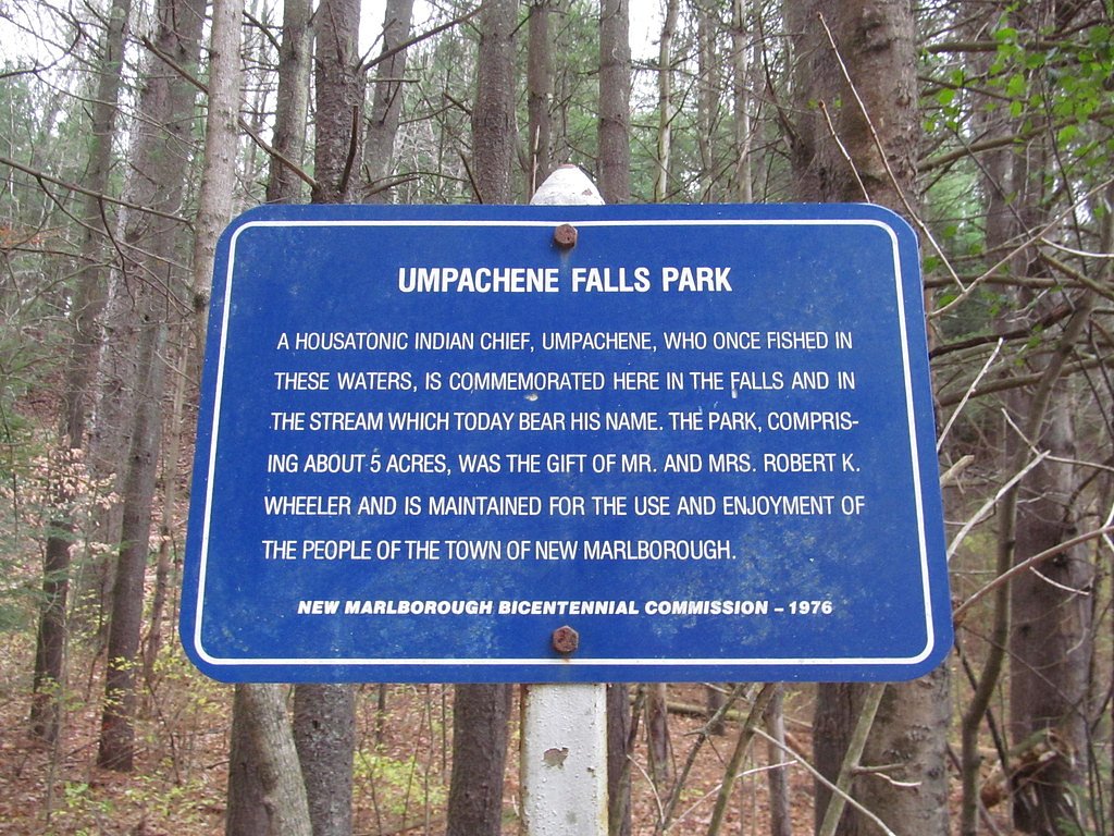
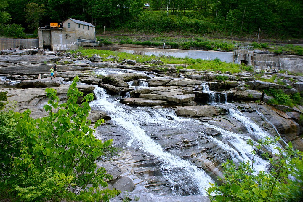
Campbell Falls
By Armen Suny · Last verified Mar 2026
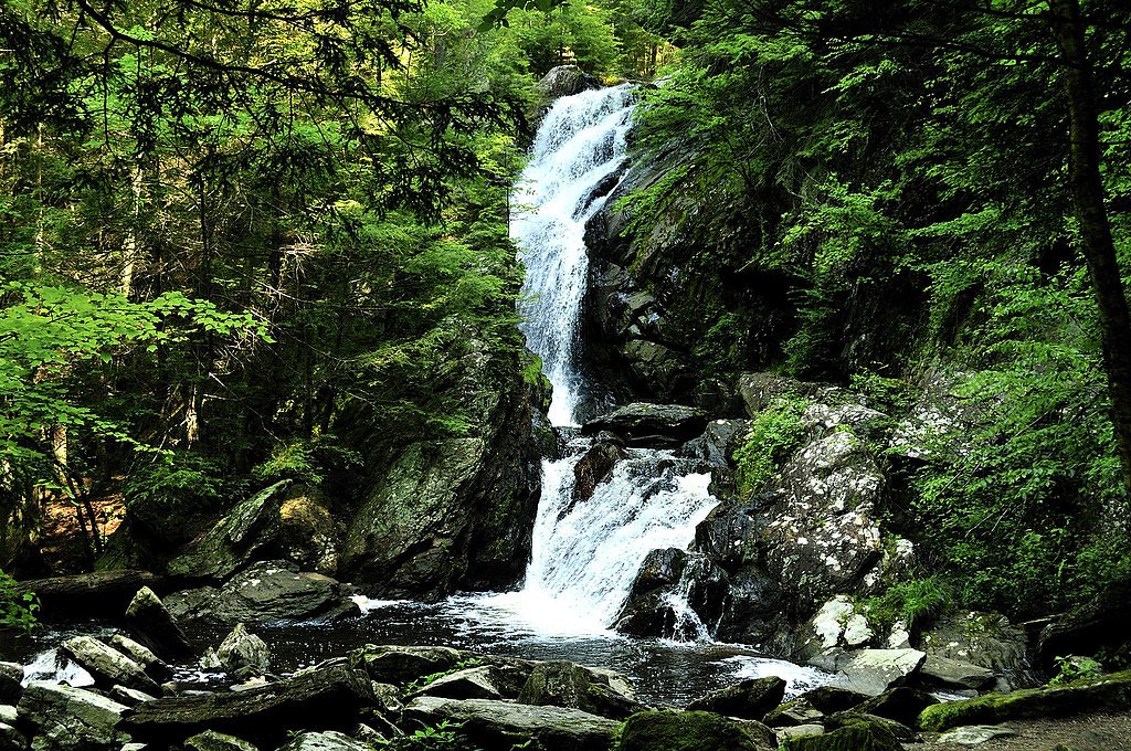
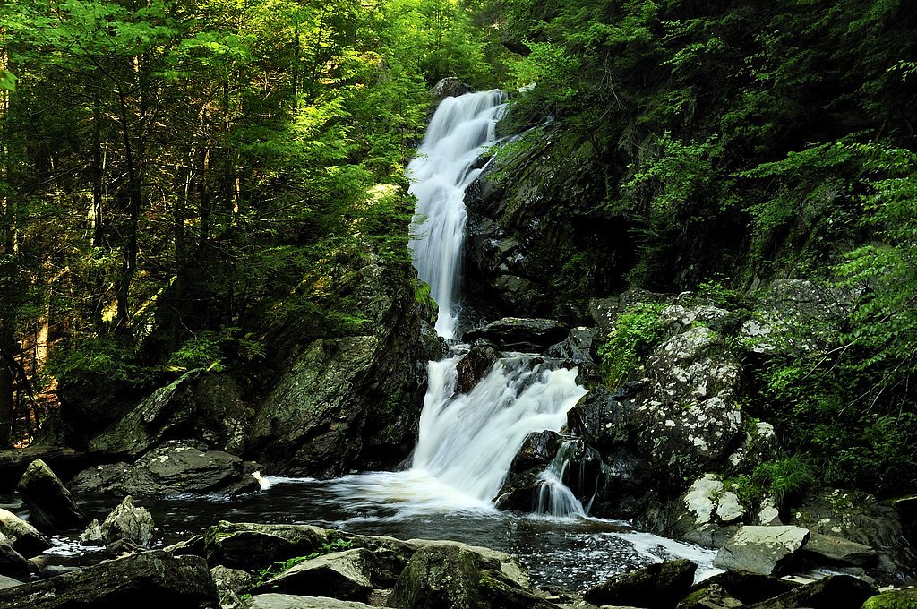
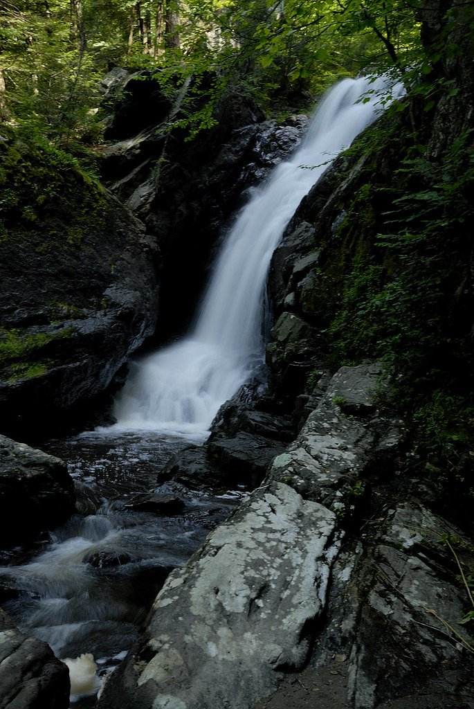
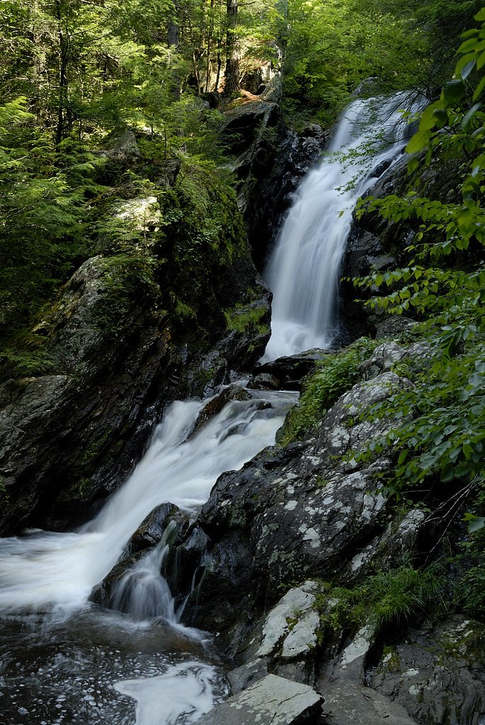

Photo Credits (5)
Difficulty
Moderate
Trail Length
2.4 miles
Trail Type
Out And Back
Elevation Gain
350 ft
About Campbell Falls
Campbell Falls is a picturesque waterfall located in the Campbell Falls State Park Reserve, which straddles the border of Massachusetts and Connecticut. The waterfall features a series of cascades and drops, surrounded by a serene forested area, making it a popular spot for nature enthusiasts.
The Setting
Campbell Falls sits at 1,024 feet within Campbell Falls State Park, fed by the Housatonic River, in the foothills of Massachusetts.
Trail & Hike Details
The Approach
The moderate 2.4-mile out-and-back trail gains 350 feet of elevation on the way to the falls.
Trail Description
The trail to Campbell Falls is a short and easy walk through a wooded area. The path is well-maintained and leads directly to the waterfall. Visitors can enjoy the peaceful surroundings and the sound of rushing water as they approach the falls.
What to Expect
Dogs are welcome.
Accessibility
The trail is not wheelchair accessible. Uneven terrain and elevation changes require steady footing.
Frequently Asked Questions
🐶 Are Dogs Allowed at Campbell Falls?
✅ Dogs are allowed
Are There Any Fees or Permits Required?
🆖 No fees required
🏊 Is There Swimming at Campbell Falls?
❌ Swimming is not allowed
When to Visit
Spring and early summer are the best times to visit, as the waterfall is typically at its fullest due to snowmelt and rainfall.
Seasonal Access
The best time to visit is Spring, Summer, and Fall. Winter access may be limited.
Safety Information
Exercise caution near the waterfall, as rocks can be slippery. Avoid visiting during heavy rain or icy conditions, as the trail may become hazardous.
Current Water Conditions
209 ft³/s
Current discharge — how much water is flowing
Much lower than usual for this time of year
Based on 21 years of record
1.87 ft
Water depth at gauge
7-Day Discharge Trend
What does this mean for your visit?
Flow is well below normal for this time of year, so the waterfall may be a trickle.
About This Gauge
This gauge is on a nearby waterway and may not reflect exact conditions at the falls.
7-Day Flow Outlook
Based on the USGS gauge HOUSATONIC RIVER NEAR ASHLEY FALLS, MA (9 km away).
Today
Low
241 cfs
3/10Tomorrow
Low
262 cfs
3/10Thu
Barely Flowing
210 cfs
5/10Fri
Barely Flowing
170 cfs
5/10Sat
Low
176 cfs
3/10Sun
Low
186 cfs
3/10Mon
Low
152 cfs
4/10Best window: Thu — barely flowing flow, sunny (trip score 5/10).
Best time of year: this gauge typically runs highest from early March to early May, peaking in April.
How we calculate this
This is a transparent outlook, not a precise forecast. We take the waterfall's current flow strength (how it ranks against its historical normal for today, from the nearest USGS stream gauge), carry that ranking forward along the gauge's seasonal curve, and nudge it for forecast rain. Confidence is highest for the next day or two and falls further out. Always check official conditions and your own judgment before visiting — high flows can be dangerous.
Know when to go.
Get a free email alert when waterfalls near Canaan hit peak flow. We only send when conditions are worth the trip — no weekly newsletters, no spam.
Weather Forecast
Location & Access
Getting There
Campbell Falls is located in Campbell Falls State Park Reserve, near the town of New Marlborough, Massachusetts. The trailhead can be accessed via Campbell Falls Road, and the park is well-marked with signs.
Get Directions on Google MapsParking
There is a small parking area near the trailhead on Campbell Falls Road. Parking may be limited during peak seasons.
Elevation
1,024 feet above sea level
Coordinates
42.045922° N, -73.232937° W
Land Management
Managed by UNK
Visitor Tips & Gear
Visit early in the day to avoid crowds, especially during weekends. Wear sturdy shoes as the trail may be muddy or slippery after rain. Bring insect repellent during warmer months.
As an Amazon Associate, we earn from qualifying purchases.
With 2.4 miles and 350 ft of elevation gain, sturdy boots and trekking poles will help on this moderate trail. Sun exposure on the trail makes good sun protection a must in summer.

Polarized Sunglasses (Knockaround)
Cuts glare off the water so you actually see the falls — and your photos turn out better too.

Columbia Watertight II Rain Jacket
Packs into its own pocket, seam-sealed, and keeps you dry from spray and surprise rain.

Earth Pak Waterproof Dry Bag
Keeps your phone and gear dry when waterfall mist soaks everything else.

Waterproof Phone Pouch (AiRunTech)
Cheap insurance — take photos right next to the falls without killing your phone.

Timberland Euro Sprint Mid Waterproof
Trusted waterproof boot with premium leather and grippy rubber sole — reliable on rocky, wet trails.

TrailBuddy Trekking Poles
Lightweight aluminum, cork grips, and flip-locks that actually hold — a best-seller for good reason.
Where to Stay

Manor House Inn

Wilder House Berkshires

The Kent Collection - The Firefly Inn

Private setting on country farm near Rhinebeck
Browse vacation cabins and private rentals nearby
Unique outdoor stays — tents, yurts, and treehouses
Rent a campervan or RV for your waterfall road trip
Some links are affiliate links. We may earn a commission at no extra cost to you.
Nearby Hot Springs
Hot springs near Canaan, Massachusetts

Lebanon Spring
Lebanon Spring discharges at 72°F at 663 feet elevation in Columbia County, flowing 24 degrees above ambient air temperature ju...
Sand Spring
Sand Spring surfaces at 75°F in Williamstown, Massachusetts — one of the few thermal features in New England. At just 670 feet ...
Looking for a soak after your hike? Explore more hot springs near Canaan, Massachusetts on SoakingSprings.
Explore Massachusetts springsAdditional Information
Nearby Attractions
Nearby attractions include the town of New Marlborough, other hiking trails in the area, and the scenic Berkshires region.
Wildlife
The area is home to a variety of wildlife, including birds, deer, and small mammals. Visitors may also see wildflowers and other native plants.
Cities near Campbell Falls
Nearby Waterfalls
Other waterfalls named Campbell Falls
1 other waterfall shares this name across the U.S.
Writing about Campbell Falls? Embed this waterfall on your site for free.