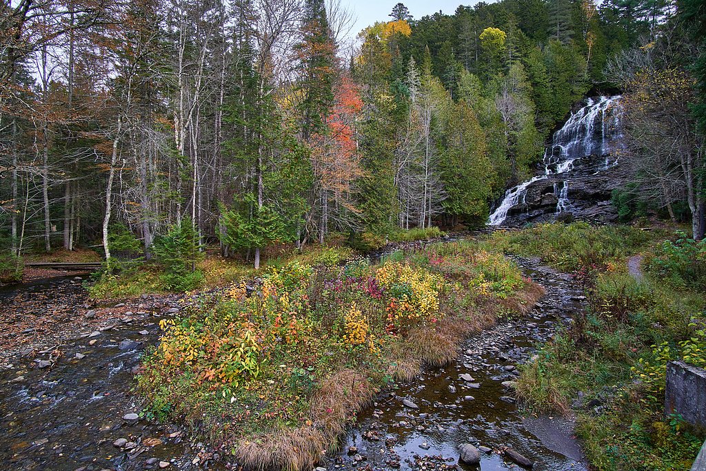
Beaver Brook Falls
New Hampshire • 80 ft
By Armen Suny · Last verified Mar 2026
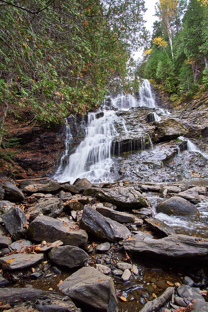
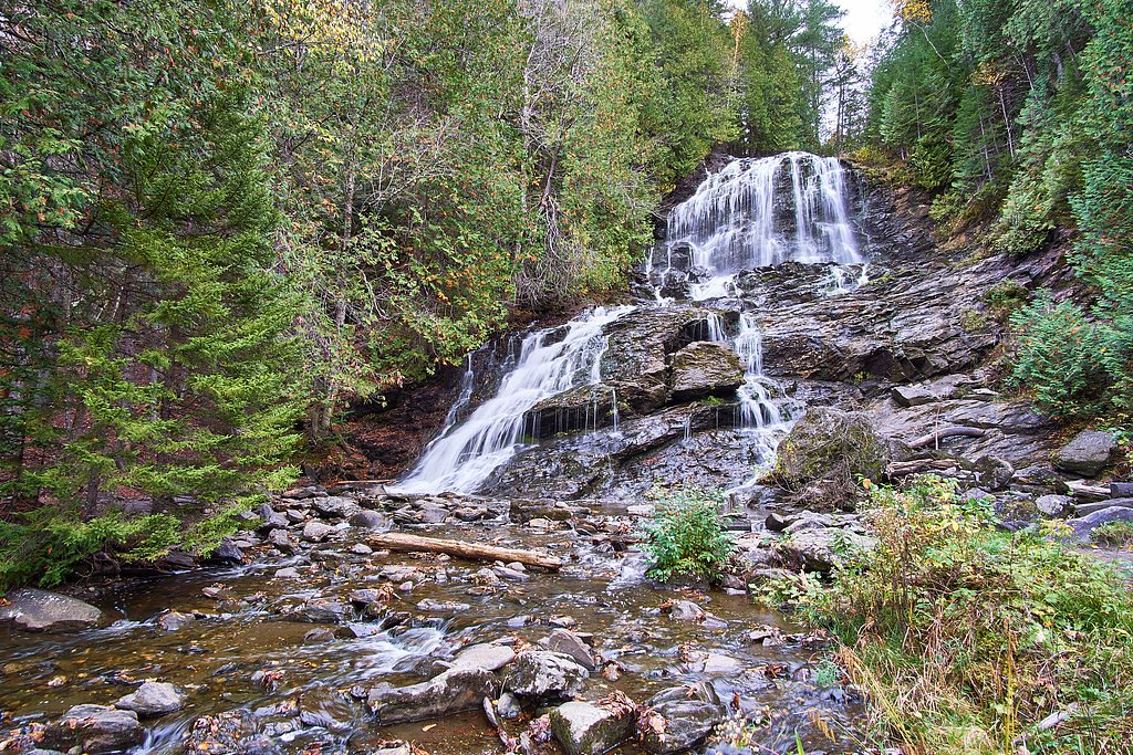
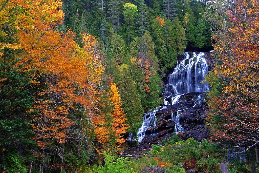


Photo Credits (5)
Difficulty
Moderate
Trail Length
2.4 miles
Trail Type
Out And Back
Elevation Gain
350 ft
About Beaver Brook Falls
Beaver Brook Falls tumbles an impressive 80 feet in a fan-shaped cascade that’s easily enjoyed from the roadside at Beaver Brook Falls Wayside in Colebrook, New Hampshire. The 7.3-acre wayside sits along Route 145 and offers a classic, low-effort waterfall stop — picnic tables, restroom facilities and a small shelter make it a comfortable place to linger and listen to the falls. The property lies within the Colebrook Town Woodlot and is city-owned, while being managed for public day-use as the state wayside.
The Setting
Beaver Brook Falls sits at 1,142 feet within Colebrook Town Woodlot, in the foothills of New Hampshire. The falls drop 80 feet.
Height: 80 feet
Trail & Hike Details
The Approach
The moderate 2.4-mile out-and-back trail gains 350 feet of elevation on the way to the falls.
Trail Description
You don’t need to hike to see the falls — the main viewpoint is immediately visible from the parking area off Route 145. For visitors who want to stretch their legs, there is a longer out-and-back route of about 2.4 miles with roughly 350 feet of elevation gain; it’s rated moderate and provides a bit more exploration of the surrounding woodlot beyond the roadside viewpoint. (No USFS trail number was provided.)
What to Expect
The falls cascade 80 feet. Dogs are welcome.
Accessibility
The trail is not wheelchair accessible. Uneven terrain and elevation changes require steady footing.
Frequently Asked Questions
🐶 Are Dogs Allowed at Beaver Brook Falls?
✅ Dogs are allowed
Are There Any Fees or Permits Required?
🆖 No fees required
🏊 Is There Swimming at Beaver Brook Falls?
❌ Swimming is not allowed
When to Visit
Spring is the best time to visit when the waterfall is at its fullest due to snowmelt. Summer and fall also offer beautiful views, while winter provides a unique opportunity to see the falls partially frozen.
Seasonal Access
The best time to visit is Spring, Summer, Fall, and Winter.
Safety Information
Exercise caution near the falls, as rocks can be slippery, especially after rain or during winter. Stay on designated paths and avoid climbing on the rocks.
Current Water Conditions
993 ft³/s
Current discharge — how much water is flowing
Much higher than usual for this time of year
Based on 69 years of record
3.83 ft
Water depth at gauge
60°F
WarmVery comfortable
7-Day Discharge Trend
What does this mean for your visit?
The water is flowing much higher than usual, expect an impressive display. Water temperature is a bracing 60 degrees F, limit your time in the water.
About This Gauge
This gauge is on a nearby waterway and may not reflect exact conditions at the falls.
7-Day Flow Outlook
Based on the USGS gauge CONNECTICUT R BELOW INDIAN STREAM NR PITTSBURG, NH (14 km away).
Today
Low
1132 cfs
3/10Tomorrow
Barely Flowing
1195 cfs
4/10Mon
Barely Flowing
1085 cfs
4/10Tue
Low
1225 cfs
3/10Wed
Low
1272 cfs
3/10Thu
Low
1243 cfs
3/10Fri
Low
1192 cfs
3/10Best window: Tomorrow — barely flowing flow, patchy fog then mostly sunny (trip score 4/10).
Best time of year: this gauge typically runs highest from mid December to late February, peaking in January.
How we calculate this
This is a transparent outlook, not a precise forecast. We take the waterfall's current flow strength (how it ranks against its historical normal for today, from the nearest USGS stream gauge), carry that ranking forward along the gauge's seasonal curve, and nudge it for forecast rain. Confidence is highest for the next day or two and falls further out. Always check official conditions and your own judgment before visiting — high flows can be dangerous.
Know when to go.
Get a free email alert when waterfalls near Beecher Falls hit peak flow. We only send when conditions are worth the trip — no weekly newsletters, no spam.
Weather Forecast
Location & Access
Getting There
Beaver Brook Falls is located along Route 145, approximately 7 miles north of Colebrook, New Hampshire. The falls are easily accessible from the roadside.
Get Directions on Google MapsParking
There is a small parking area available at the Beaver Brook Falls Wayside, located directly off Route 145.
Elevation
1,142 feet above sea level
Coordinates
44.919214° N, -71.463695° W
Land Management
Managed by UNK
Visitor Tips & Gear
Visit early in the morning or on weekdays to avoid crowds. Bring a camera to capture the scenic beauty. The area can be slippery during wet or icy conditions, so wear appropriate footwear.
As an Amazon Associate, we earn from qualifying purchases.
With 2.4 miles and 350 ft of elevation gain, sturdy boots and trekking poles will help on this moderate trail. Icy conditions are common in winter — traction cleats are a smart addition.

Columbia Watertight II Rain Jacket
Packs into its own pocket, seam-sealed, and keeps you dry from spray and surprise rain.

Polarized Sunglasses (Knockaround)
Cuts glare off the water so you actually see the falls — and your photos turn out better too.

Earth Pak Waterproof Dry Bag
Keeps your phone and gear dry when waterfall mist soaks everything else.

Waterproof Phone Pouch (AiRunTech)
Cheap insurance — take photos right next to the falls without killing your phone.

Timberland Euro Sprint Mid Waterproof
Trusted waterproof boot with premium leather and grippy rubber sole — reliable on rocky, wet trails.

TrailBuddy Trekking Poles
Lightweight aluminum, cork grips, and flip-locks that actually hold — a best-seller for good reason.
Where to Stay

Étoile du Lac Lyster - Spa & Vue sur le Lac

La Maison Bleue du Lac Wallace

Ladd Pond Cabins and Campground, LLC

House & loft, pool table, ping-pong, fireplace, AC
Browse vacation cabins and private rentals nearby
Unique outdoor stays — tents, yurts, and treehouses
Rent a campervan or RV for your waterfall road trip
Some links are affiliate links. We may earn a commission at no extra cost to you.
Additional Information
Nearby Attractions
Nearby attractions include Dixville Notch State Park, the Balsams Wilderness area, and the town of Colebrook, which offers dining and shopping options.
Wildlife
The area around Beaver Brook Falls is home to various wildlife, including birds, deer, and small mammals. Visitors may also spot wildflowers and other native plants.
Cities near Beaver Brook Falls
Nearby Waterfalls
Other waterfalls named Beaver Brook Falls
1 other waterfall shares this name across the U.S.
Writing about Beaver Brook Falls? Embed this waterfall on your site for free.