Ash Creek Falls
By Armen Suny · Last verified Mar 2026
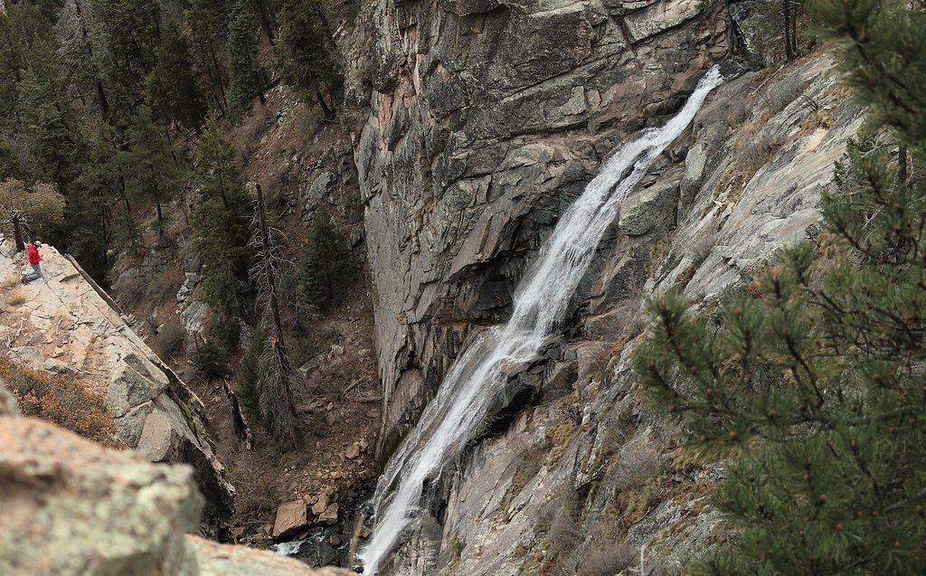

Photo Credits (3)
Difficulty
Hard
Trail Length
4.5 miles
Trail Type
Out And Back
Elevation Gain
2 ft
About Ash Creek Falls
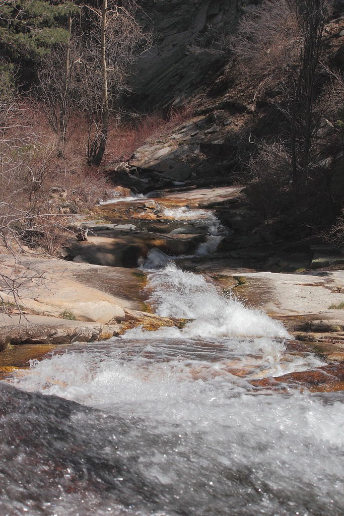
Ash Creek Falls tumbles through a remote, forested canyon in the Pinaleño Mountains of southeastern Arizona, offering a quiet mountain escape from the desert lowlands. The cascade threads through shaded boulder fields and quiet pools, creating an intimate setting that feels like a well-earned reward for hikers who make the journey. Photographers and nature lovers will appreciate the close, tucked-in character of the falls more than wide-open views — it's a cool, green pocket of the high country. Reaching the falls requires a commitment: the route is an out-and-back of about 4.5 miles round trip with a negligible net elevation change (roughly 2 feet), but it’s rated hard because of rugged, uneven footing and occasional route-finding rather than steep climbing. If you plan to overnight, Riggs Lake Campground sits about 6.82 km (≈4.2 miles) from the falls and makes a convenient nearby basecamp for a longer Pinaleño outing. Come prepared with sturdy boots, plenty of water, and time to move carefully — the reward is a peaceful, shaded waterfall in a surprisingly lush canyon.
The Setting
Ash Creek Falls sits at 7,913 feet along the Bonita Creek, in the high mountains of Arizona.
Trail & Hike Details
The Approach
The hard 4.5-mile out-and-back trail gains 2 feet of elevation on the way to the falls.
Trail Description
Length: ~4.5 miles round trip; Elevation gain: ~2 feet; Type: out-and-back; Difficulty: hard. The tread is frequently narrow, rocky, and uneven with limited built trail infrastructure. Expect exposed roots, loose rock, and occasional steep or slippery approaches near creek crossings that require careful footing and basic route-finding skills. The minimal net elevation change belies the technical nature of the route—wear sturdy footwear, carry water, and allow extra time for slow, careful travel on the rough sections.
What to Expect
Visitors can expect a strenuous hike with rewarding views of the waterfall and surrounding wilderness. The falls are most impressive after periods of rain or during spring snowmelt. Wildlife sightings, such as deer or birds, are common in the area.
Accessibility
The trail involves steep, uneven terrain with significant elevation change and is not accessible to mobility devices.
Frequently Asked Questions
🐶 Are Dogs Allowed at Ash Creek Falls?
❌ Dogs are not allowed
Are There Any Fees or Permits Required?
🆖 No fees required
🏊 Is There Swimming at Ash Creek Falls?
❌ Swimming is not allowed
When to Visit
Spring and early summer are the best times to visit, as the waterfall flow is typically strongest during these seasons.
Seasonal Access
The best time to visit is Spring, Summer, and Fall. Access roads and trails may close during winter due to snow. Watch for flash flood warnings during monsoon season (July through September).
Safety Information
The trail can be steep and rugged, with loose rocks in some areas. Be prepared for sudden weather changes and carry sufficient water. Watch for wildlife, including snakes. Let someone know your hiking plans before heading out.
Current Water Conditions
Based on a USGS gauge 26.2 miles away
6 ft³/s
Current discharge — how much water is flowing
Much higher than usual for this time of year
Based on 44 years of record
4.92 ft
Water depth at gauge
7-Day Discharge Trend
What does this mean for your visit?
The water is flowing much higher than usual, expect an impressive display.
About This Gauge
This gauge is on a regional waterway. Conditions at the falls may differ, especially after local rain.
7-Day Flow Outlook
Based on the USGS gauge BONITA CREEK NEAR MORENCI, AZ. (42 km away).
Today
Roaring
7 cfs
6/10Tomorrow
Roaring
7 cfs
9/10Sun
Roaring
6 cfs
9/10Mon
Roaring
6 cfs
9/10Tue
Roaring
6 cfs
9/10Wed
Roaring
6 cfs
9/10Thu
Roaring
6 cfs
9/10Best window: Tomorrow — roaring flow, sunny (trip score 9/10).
Best time of year: this gauge typically runs highest from mid December to late February, peaking in January.
How we calculate this
This is a transparent outlook, not a precise forecast. We take the waterfall's current flow strength (how it ranks against its historical normal for today, from the nearest USGS stream gauge), carry that ranking forward along the gauge's seasonal curve, and nudge it for forecast rain. Confidence is highest for the next day or two and falls further out. Always check official conditions and your own judgment before visiting — high flows can be dangerous.
Know when to go.
Get a free email alert when waterfalls near Swift Trail Junction hit peak flow. We only send when conditions are worth the trip — no weekly newsletters, no spam.
Weather Forecast
Location & Access
Getting There
Ash Creek Falls is located in the Coronado National Forest, near Mount Graham. Access typically involves driving to the Ash Creek Trailhead, which is reached via dirt roads that may require a high-clearance vehicle, especially after rain.
Get Directions on Google MapsParking
Parking is available at the Ash Creek Trailhead, but spaces may be limited. Visitors should plan to arrive early, especially during weekends or peak seasons.
Elevation
7,913 feet above sea level
Coordinates
32.729791° N, -109.893969° W
Visitor Tips & Gear
Start early to avoid hiking in the heat, and bring plenty of water and snacks. Wear sturdy hiking boots and be prepared for changing weather conditions. Cell service may be unreliable, so carry a map or GPS device.
This trail sits at 7,913 ft above sea level
Elevated TrailUV radiation is roughly 32% stronger at this elevation than at sea level, and the dry air accelerates dehydration. Extra sun protection and fluids go a long way.
As an Amazon Associate, we earn from qualifying purchases.

Coppertone Sport SPF 50 Sunscreen
UV intensity jumps ~4% per 1,000 ft — at this elevation you can burn in half the time.

Sun Bum SPF 30 Lip Balm (3-Pack)
Lips have almost no natural UV protection and burn fast in thin, dry mountain air.

Liquid I.V. Electrolyte Packets
You lose moisture ~2x faster at elevation — electrolytes help you absorb water efficiently.

ROCKNIGHT Polarized UV400 Sunglasses
High-altitude glare off rock and water is intense — UV400 lenses block 99%+ of UVA/UVB.
As an Amazon Associate, we earn from qualifying purchases.
This challenging 4.5 miles trail gains 2 ft in elevation — come prepared with proper hiking boots and trekking poles. Sun exposure on the trail makes good sun protection a must in summer.

Sawyer Squeeze Water Filter
The backcountry standard — filters 99.9% of bacteria and weighs just 3 oz.

Polarized Sunglasses (Knockaround)
Cuts glare off the water so you actually see the falls — and your photos turn out better too.

Columbia Watertight II Rain Jacket
Packs into its own pocket, seam-sealed, and keeps you dry from spray and surprise rain.

Earth Pak Waterproof Dry Bag
Keeps your phone and gear dry when waterfall mist soaks everything else.

Waterproof Phone Pouch (AiRunTech)
Cheap insurance — take photos right next to the falls without killing your phone.

Timberland Euro Sprint Mid Waterproof
Trusted waterproof boot with premium leather and grippy rubber sole — reliable on rocky, wet trails.
Where to Stay

Thatcher Home with Fenced Backyard 3 Mi to Downtown

Best Western Desert Inn

Days Inn by Wyndham Safford, AZ

Comfort Inn and Suites Thatcher
Browse vacation cabins and private rentals nearby
Unique outdoor stays — tents, yurts, and treehouses
Rent a campervan or RV for your waterfall road trip
Some links are affiliate links. We may earn a commission at no extra cost to you.
Nearby Campground
Riggs Lake
4.2 miles away · 1 sites
Overview Riggs Flat Lake is located at the end of Swift Trail, a road that winds along the top of the Pinaleno Mountains. It is a small picturesque lake, 11 acres in size, set in alpine forest and meadow. Its cold waters are stocked during the summer with rainbow, brown and brook trout, and anglers report that the fishing is usually good. Best baits for the rainbows are corn, cheese, garlic cheese, salmon eggs, and worms. The brown and brook trout are taken on artificial lures and flies as well.
Book on Recreation.govNearby Hot Springs
Hot springs near Swift Trail Junction, Arizona
Roper Lake State Park Hot Spring
Roper Lake State Park Hot Spring provides developed thermal water recreation at 72°F within a popular state park near Safford, ...

Indian Hot Springs
Indian Hot Springs (also called Holladay Hot Springs) flows at 118°F, emerging just 165 feet from Hot Springs Road in Graham Co...
Grapevine Spring
Flowing 26 degrees above ambient temperatures, Grapevine Spring emerges at 91°F from Arizona State Trust Land near Pima in Grah...
Warm Spring
Warm Spring flows at 90°F in Graham County near Bylas, emerging 21 degrees above the region's 69°F average on Bureau of Land Ma...
Hot Well Dunes
Hot Well Dunes sits essentially roadside at just 190 feet from the nearest road on BLM public lands in Graham County. This unus...
Warm Spring
This 79-degree thermal spring sits on Bureau of Land Management lands near Bylas in Graham County, running 15.3 degrees warmer ...
Looking for a soak after your hike? Explore more hot springs near Swift Trail Junction, Arizona on SoakingSprings.
Explore Arizona springsAdditional Information
Nearby Attractions
Mount Graham, Riggs Flat Lake, and other trails in the Coronado National Forest.
Wildlife
The area is home to diverse wildlife, including deer, birds, and small mammals. Be cautious of snakes, especially during warmer months.
Cities near Ash Creek Falls
Other waterfalls named Ash Creek Falls
1 other waterfall shares this name across the U.S.
Writing about Ash Creek Falls? Embed this waterfall on your site for free.