Difficulty
Moderate
Trail Length
4.0 miles
Trail Type
Out And Back
Elevation Gain
500 ft
About Ash Creek Falls
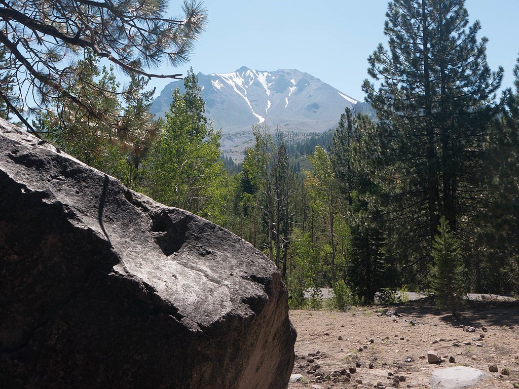
Ash Creek Falls plunges approximately 290 feet through forested cliffs in northern California, a remote and dramatic cascade tucked into Shasta National Forest and managed by the U.S. Forest Service. The falls’ lofty drop and quiet, wooded surroundings make it a rewarding destination for hikers who want a scenic payoff without crowds. Access to the falls is via the USFS Clear Creek Trail (Trail #02W01). The hike is commonly listed as a 4.0-mile out-and-back with about 500 feet of elevation gain and a moderate difficulty rating. The route follows native-surface tread with some steeper pitches (USFS typical grade 12–20%), so come prepared with solid footwear and expect a mix of steady climbs and forested views along the way.
Height: 290 feet
Trail & Hike Details
The Approach
The moderate hike follows Clear Creek (#02W01), a 4.0-mile out-and-back trail over natural surface. Expect 500 feet of elevation gain with grades of 12-20%. The trail is developed (Class 3).
USFS Trail
CLEAR CREEK #02W01
Trail Class
Developed
Surface
Avg Grade
USFS Segment
2.11 miTrail Description
Clear Creek Trail (USFS Trail #02W01) is the primary route to Ash Creek Falls. Trail stats: length commonly reported as 4.0 miles (out-and-back), USFS GIS miles 2.11, elevation gain ~500 ft, difficulty: moderate, trail type: out-and-back. Surface: native material. Class: 3. Typical grade: 12–20%. The tread is natural/native material and includes sustained grades in places; the USFS class and grade indicate sections of steeper, uneven trail where careful footing is recommended.
What to Expect
The falls plunge 290 feet. Dogs are welcome.
Accessibility
The trail is not wheelchair accessible. Uneven terrain and elevation changes require steady footing.
Frequently Asked Questions
🐶 Are Dogs Allowed at Ash Creek Falls?
✅ Dogs are allowed
Are There Any Fees or Permits Required?
🆖 No fees required
🏊 Is There Swimming at Ash Creek Falls?
❌ Swimming is not allowed
When to Visit
Spring is the best time to visit Ash Creek Falls, as the water flow is typically strongest after winter snowmelt. Summer and fall are also good options, but the flow may be reduced.
Seasonal Access
The best time to visit is Spring, Summer, and Fall. Winter access may be limited. Check with Shasta National Forest for seasonal road closures.
Safety Information
The trail can be slippery and uneven in places. Watch for loose rocks and be cautious near the edge of the falls. Always check weather and trail conditions before heading out.
Know when to go.
Get a free email alert when waterfalls near McCloud hit peak flow. We only send when conditions are worth the trip — no weekly newsletters, no spam.
Weather Forecast
Location & Access
Getting There
Ash Creek Falls is located near the McCloud area in Northern California. Access typically involves driving on forest roads, which may be unpaved and rough in some sections. A high-clearance vehicle is recommended.
Get Directions on Google MapsParking
Parking is available at a trailhead near the access point, but spaces may be limited. Visitors should plan to arrive early, especially during peak seasons.
Elevation
0 feet above sea level
Coordinates
41.403805° N, -122.136276° W
Land Management
Managed by USFS
Visitor Tips & Gear
Wear sturdy hiking shoes and bring plenty of water. Check road and trail conditions before your visit, as access may be affected by weather. Cell service may be limited in the area, so plan accordingly.
As an Amazon Associate, we earn from qualifying purchases.
With 4.0 miles and 500 ft of elevation gain, sturdy boots and trekking poles will help on this moderate trail. Sun exposure on the trail makes good sun protection a must in summer.

Polarized Sunglasses (Knockaround)
Cuts glare off the water so you actually see the falls — and your photos turn out better too.

Columbia Watertight II Rain Jacket
Packs into its own pocket, seam-sealed, and keeps you dry from spray and surprise rain.

Earth Pak Waterproof Dry Bag
Keeps your phone and gear dry when waterfall mist soaks everything else.

Waterproof Phone Pouch (AiRunTech)
Cheap insurance — take photos right next to the falls without killing your phone.

Timberland Euro Sprint Mid Waterproof
Trusted waterproof boot with premium leather and grippy rubber sole — reliable on rocky, wet trails.

TrailBuddy Trekking Poles
Lightweight aluminum, cork grips, and flip-locks that actually hold — a best-seller for good reason.
Where to Stay

Shasta View Lodge

Basecamp Lodge

Inn At Mount Shasta

Cold Creek Inn
Browse vacation cabins and private rentals nearby
Unique outdoor stays — tents, yurts, and treehouses
Rent a campervan or RV for your waterfall road trip
Some links are affiliate links. We may earn a commission at no extra cost to you.
Nearby Campground
RED FIR FLAT GROUP CAMPGROUND
7.3 miles away · 1 sites
Overview Red Fir Flat Group Campground is located on the southern slope of Mt. Shasta at 6,400 feet in elevation. Snowpack in this location may extend into late June on heavy snow years, and usually sees late season snowfall in early November, possibly October. It is a popular site for meditation/retreat groups. Maximum stay limit is 7 days per group and or indvidual(s) Recreation Most visitors enjoy the peace and solitude of the forest setting. Several hiking trails are located nearby, including
Book on Recreation.govNearby Hot Springs
Hot springs near McCloud, California

Hot Spring, Fumaroles
Hot Spring with fumaroles on Mount Shasta at 14,000 feet elevation represents one of California's highest thermal features, wit...
Hunt Hot Spring
Hunt Hot Spring produces 136-degree water from the forested slopes near McCloud in Siskiyou County at just 1,712 feet elevation...
Big Bend Hot Springs
Big Bend Hot Springs surges at a scalding 180 degrees Fahrenheit from volcanic terrain at just 1,644 feet elevation, creating o...
Big Bend, California
Big Bend sits along a dramatic curve of the Pit River in Shasta County at 1,720 feet elevation, occupying territory historicall...
Klamath Hot Spring
Klamath Hot Spring discharges at 156°F just 27 feet from the nearest road near Montague in Siskiyou County, making it extraordi...
Bogus Soda Springs
Bogus Soda Springs flows at 76°F from Siskiyou County's volcanic landscape at 2,801 feet elevation. The name suggests early ske...
Looking for a soak after your hike? Explore more hot springs near McCloud, California on SoakingSprings.
Explore California springsAdditional Information
Nearby Attractions
McCloud Falls, Mount Shasta, and Castle Crags State Park are popular nearby destinations.
Wildlife
The area is home to a variety of wildlife, including deer, birds, and occasionally black bears. Be cautious and follow Leave No Trace principles.
Cities near Ash Creek Falls
Nearby Waterfalls
Other waterfalls named Ash Creek Falls
1 other waterfall shares this name across the U.S.
Writing about Ash Creek Falls? Embed this waterfall on your site for free.