Asbestos Falls
By Armen Suny · Last verified May 2026
Difficulty
Easy
Trail Length
1.2 miles
Trail Type
Out And Back
Elevation Gain
200 ft
About Asbestos Falls
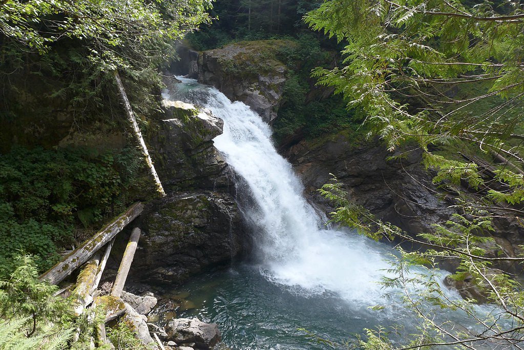
Asbestos (Asbestos Creek) Falls plunges through a steep gorge in the North Cascades within Mt. Baker National Forest, managed by the U.S. Forest Service. The falls tumble on Asbestos Creek, a small tributary of Clear Creek just below the mouth of Helena Creek; estimates put the total drop somewhere between 500 and 1,000 feet. Many sources note the falls may drop around 1,000 feet in total, though only the lower ~500 feet are visible from the base because of the shape of the gorge, producing a dramatic, multi-stepped view where you can see powerful lower tiers spilling into the canyon. Access to the viewpoint is friendly for most hikers but more adventurous than a roadside stop. The official USFS route to the area is the Frog Lake Trail (Trail #659), and the trail corridor and surrounding lands are managed by the U.S. Forest Service. The signed/recorded Frog Lake Trail is listed in USFS GIS at about 0.98 miles, while many guide descriptions put the common hike to the falls at roughly 1.2 miles with about 200 feet of elevation gain (out-and-back, rated easy). Note that Clear Creek Road has experienced numerous washouts in recent years, which can make the approach from the main road difficult; Clear Creek Campground is the nearest campground, about 3.72 km away. Wear sturdy footwear—the native-surface trail can be muddy and slippery in wet weather—and plan extra time for any rough road or trail conditions.
The Setting
Asbestos Falls sits at 1,175 feet within Mt. Baker National Forest, fed by the Sauk River, in the foothills of Washington.
Trail & Hike Details
The Approach
The easy hike follows Frog Lake (#659), a 1.2-mile out-and-back trail over natural surface. Expect 200 feet of elevation gain with grades of 12-20%. The trail is developed (Class 3).
USFS Trail
FROG LAKE #659
Trail Class
Developed
Surface
Avg Grade
USFS Segment
0.98 miTrail Description
Frog Lake Trail (USFS Trail #659) — Surface: NAT (native material); USFS class: 3; Typical grade: 12–20%. USFS GIS lists the Frog Lake Trail at 0.98 miles; common hike descriptions put the route to Asbestos Falls at about 1.2 miles round trip with ~200 feet elevation gain. Trail type: out-and-back; difficulty: easy. The single-track winds through dense forest on a mostly native dirt tread and can become muddy or slippery after rain. Expect short steeper pitches consistent with the 12–20% grade and some route-finding where fallen debris or washouts occur; access can also be complicated by washouts along Clear Creek Road, so check current road conditions before you go.
What to Expect
Dogs are welcome.
Accessibility
The trail is not wheelchair accessible. Uneven terrain and elevation changes require steady footing.
Frequently Asked Questions
🐶 Are Dogs Allowed at Asbestos Falls?
✅ Dogs are allowed
Are There Any Fees or Permits Required?
🤑 Fee: $0.00
Permit required
A Northwest Forest Pass or equivalent is required for parking at the trailhead.
🏊 Is There Swimming at Asbestos Falls?
❌ Swimming is not allowed
When to Visit
Spring and early summer are ideal for visiting Asbestos Falls, as the water flow is typically at its peak during these seasons.
Seasonal Access
The best time to visit is Spring, Summer, and Fall. Winter access may be limited. Check with Mt. Baker National Forest for seasonal road closures.
Safety Information
The trail may be slippery, especially after rain. Visitors should exercise caution near the waterfall, as the rocks can be wet and unstable. Always stay on marked trails.
Current Water Conditions
611 ft³/s
Current discharge — how much water is flowing
Much lower than usual for this time of year
Based on 102 years of record
3.28 ft
Water depth at gauge
56°F
ColdBracing — limit time in water
7-Day Discharge Trend
What does this mean for your visit?
Flow is well below normal for this time of year, so the waterfall may be a trickle. Water temperature is a bracing 56 degrees F, limit your time in the water.
About This Gauge
7-Day Flow Outlook
Based on the USGS gauge SAUK RIVER AB WHITE CHUCK RIVER NR DARRINGTON, WA (8 km away).
Today
Barely Flowing
660 cfs
3/10Tomorrow
Low
673 cfs
4/10Mon
Low
653 cfs
4/10Tue
Low
642 cfs
4/10Wed
Low
630 cfs
4/10Thu
Low
642 cfs
4/10Fri
Low
614 cfs
4/10Best window: Tomorrow — low flow, light rain likely (trip score 4/10).
Best time of year: this gauge typically runs highest from late April to mid July, peaking in June.
How we calculate this
This is a transparent outlook, not a precise forecast. We take the waterfall's current flow strength (how it ranks against its historical normal for today, from the nearest USGS stream gauge), carry that ranking forward along the gauge's seasonal curve, and nudge it for forecast rain. Confidence is highest for the next day or two and falls further out. Always check official conditions and your own judgment before visiting — high flows can be dangerous.
Know when to go.
Get a free email alert when waterfalls near Darrington hit peak flow. We only send when conditions are worth the trip — no weekly newsletters, no spam.
Weather Forecast
Location & Access
Getting There
Asbestos Falls is located near the Mountain Loop Highway in the North Cascades. To reach the falls, visitors typically take a short drive from Granite Falls, Washington. The trailhead is accessed via a forest road, which may require a high-clearance vehicle depending on conditions.
Get Directions on Google MapsParking
Limited parking is available near the trailhead. Visitors should be prepared for unpaved and potentially rough parking conditions.
Elevation
1,175 feet above sea level
Coordinates
48.186775° N, -121.574844° W
Land Management
Managed by USFS
Visitor Tips & Gear
Visit during the spring or early summer for the best water flow. Bring sturdy shoes, as the trail can be muddy. Check road and trail conditions before heading out, especially in winter or after heavy rains.
As an Amazon Associate, we earn from qualifying purchases.
This easy 1.2 miles hike is straightforward — comfortable trail shoes and plenty of water should do. Sun exposure on the trail makes good sun protection a must in summer.

Columbia Watertight II Rain Jacket
Packs into its own pocket, seam-sealed, and keeps you dry from spray and surprise rain.

Earth Pak Waterproof Dry Bag
Keeps your phone and gear dry when waterfall mist soaks everything else.

Waterproof Phone Pouch (AiRunTech)
Cheap insurance — take photos right next to the falls without killing your phone.

Polarized Sunglasses (Knockaround)
Cuts glare off the water so you actually see the falls — and your photos turn out better too.

Osprey Daylite Daypack
Light, organized, and just the right size for a day hike — fits water, snacks, and layers.

OR Sombriolet Sun Hat
UPF 50+ sun protection with vents so your head doesn't cook on exposed trail sections.
Where to Stay

PNW River Cabin

Cozy Darrington Cottage w/ Grill, Near Trails

Sauk River Cabins - Hot tub - Firepit

Glacier Peak Resort and RV Park
Browse vacation cabins and private rentals nearby
Unique outdoor stays — tents, yurts, and treehouses
Rent a campervan or RV for your waterfall road trip
Some links are affiliate links. We may earn a commission at no extra cost to you.
Nearby Campground
Clear Creek Campground
2.3 miles away · 13 sites
Overview Clear Creek Campground is located just off the Mountain Loop Highway in the stunning Mt. Baker-Snoqualmie National Forest. Nestled in a towering canopy of fir trees, this campground offers plenty of open spaces, making it perfect for small groups and family excursions. Mt. Baker-Snoqualmie National Forest sits on the west side of the Cascades in Washington, showcasing glacier-covered peaks, wide mountain meadows and old-growth forests, rich in history and outdoor opportunities.Recreation
Book on Recreation.govNearby Hot Springs
Hot springs near Darrington, Washington
Kennedy Hot Spring
Kennedy Hot Spring flows at 100 degrees at 3,520 feet elevation in the Mt. Baker National Forest, emerging 58.7 degrees above a...
Sulphur Creek Hot Springs
Sulphur Creek Hot Springs flows at 99 degrees Fahrenheit at 2,973 feet elevation in Mount Baker National Forest's remote backco...
Gamma Hot Springs
Gamma Hot Springs produces 140-degree water at 5,397 feet elevation in the Mt. Baker National Forest, emerging 104.6 degrees ab...
Garland Mineral Springs
Garland Mineral Springs flows at 84 degrees in the Snoqualmie National Forest, producing water 39.6 degrees above ambient tempe...
Baker Hot Spring
Baker Hot Spring emerges at 108 degrees Fahrenheit on US Forest Service land in Mt. Baker National Forest, flowing 59.5 degrees...

Sherman Crater Fumaroles
Sherman Crater Fumaroles register 266 degrees Fahrenheit at 9,463 feet elevation within the active volcanic crater atop Mount B...
Looking for a soak after your hike? Explore more hot springs near Darrington, Washington on SoakingSprings.
Explore Washington springsAdditional Information
Nearby Attractions
Nearby attractions include Big Four Ice Caves, Mount Pilchuck, and other waterfalls along the Mountain Loop Highway.
Wildlife
The area is home to a variety of wildlife, including birds, deer, and small mammals. Visitors should be cautious of bears and other larger animals in the region.
Cities near Asbestos Falls
Nearby Waterfalls
Writing about Asbestos Falls? Embed this waterfall on your site for free.