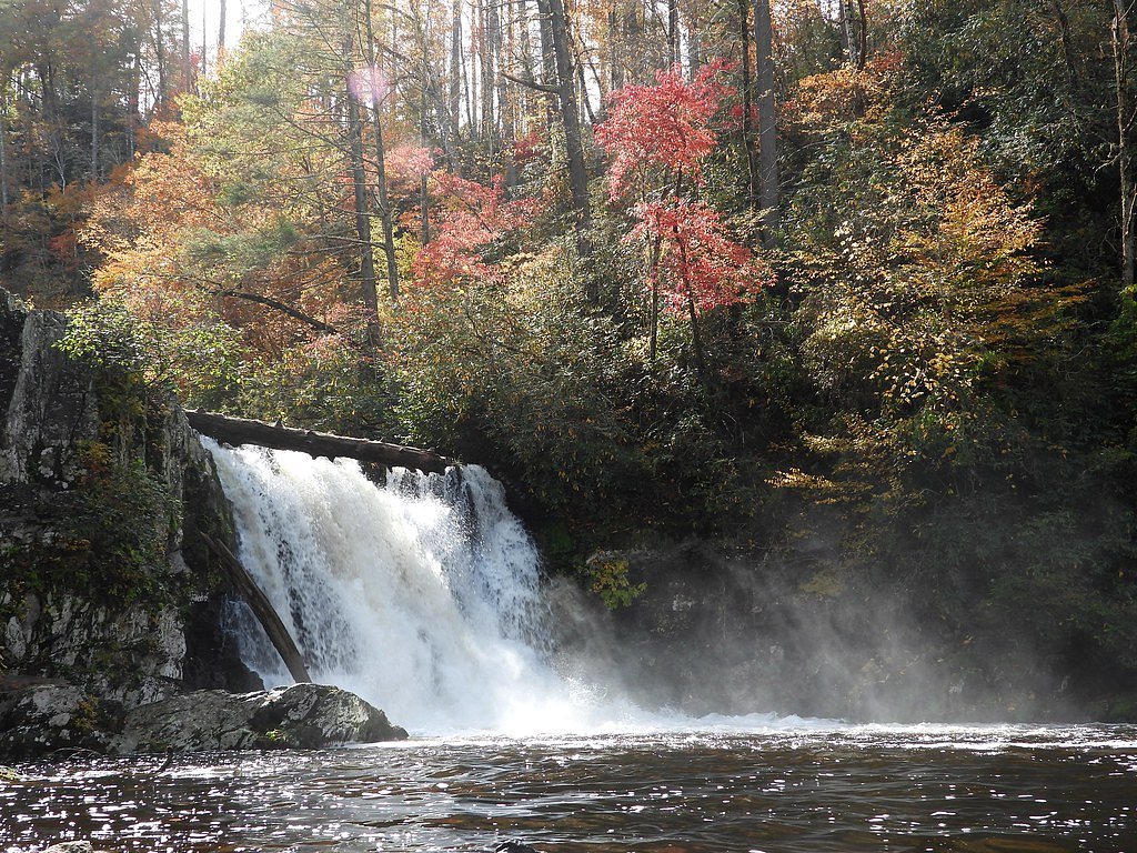
Abrams Falls
Tennessee • 20 ft
By Armen Suny · Last verified Mar 2026
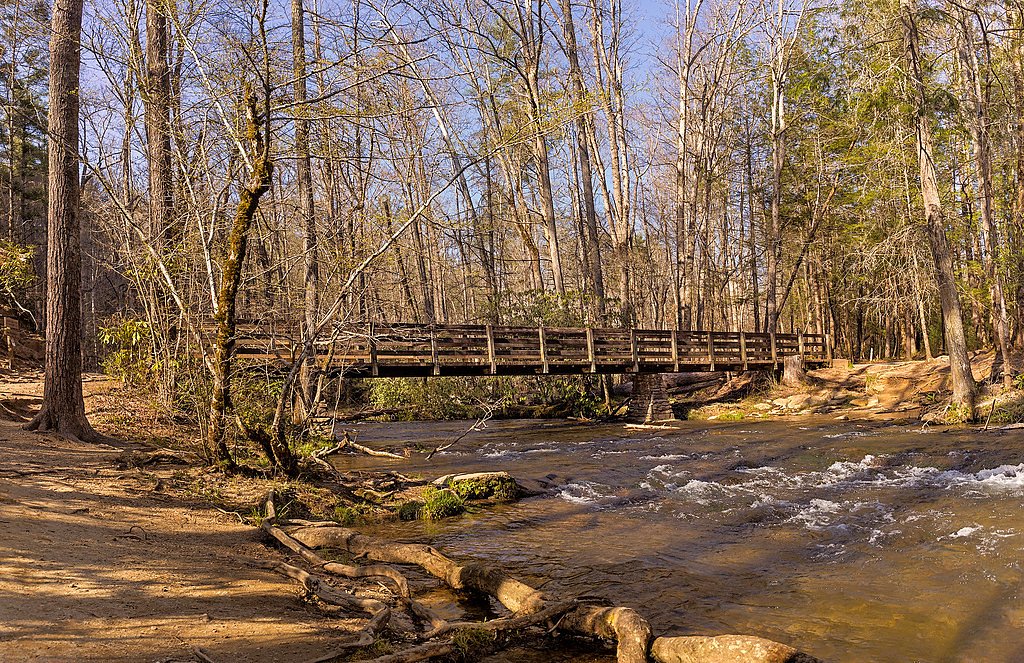
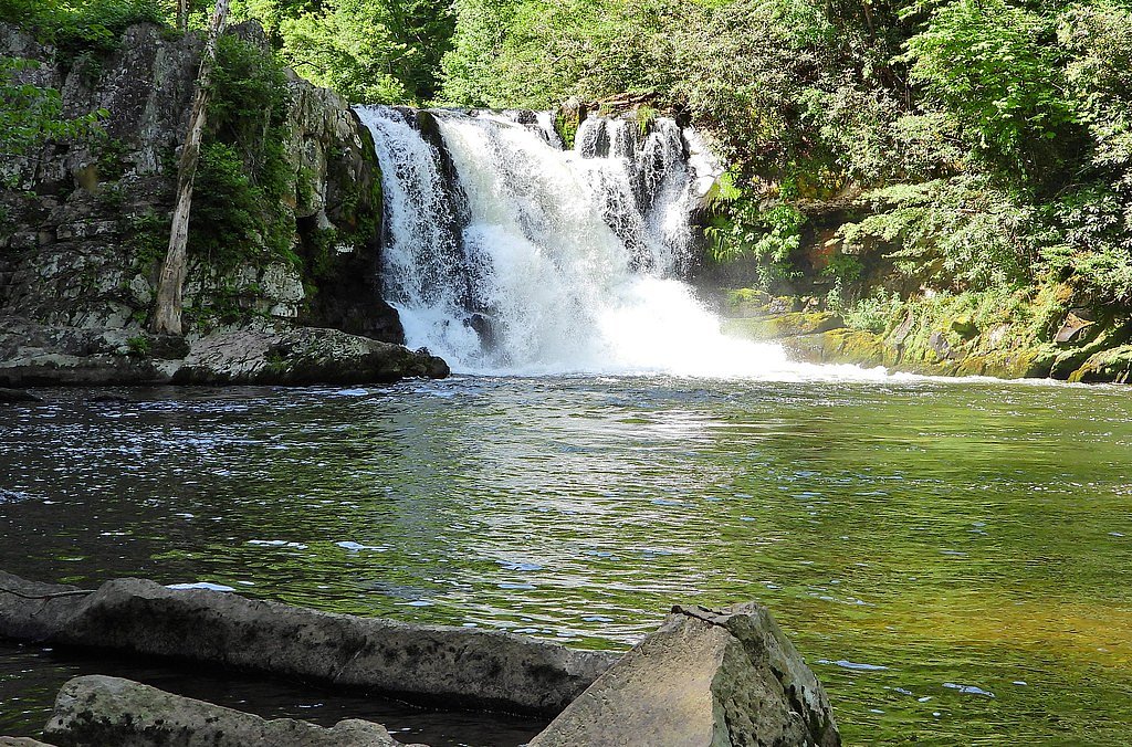

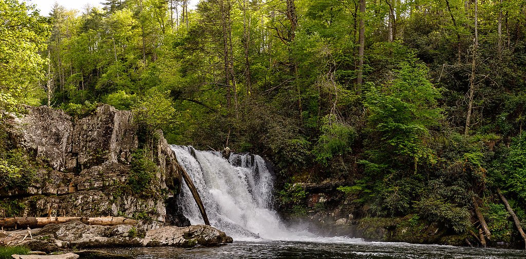

Photo Credits (5)
Difficulty
Moderate
Trail Length
5.0 miles
Trail Type
Out And Back
Elevation Gain
675 ft
About Abrams Falls
Abrams Falls is a picturesque waterfall located in the Great Smoky Mountains National Park in Tennessee. Known for its powerful flow and scenic surroundings, the waterfall is a popular destination for hikers and nature enthusiasts.
The Setting
Abrams Falls sits at 1,490 feet within Great Smoky Mountains National Park, fed by the Little River, in the foothills of Tennessee. The falls drop 20 feet.
Height: 20 feet
Trail & Hike Details
The Approach
The moderate 5.0-mile out-and-back trail gains 675 feet of elevation on the way to the falls.
Trail Description
The Abrams Falls Trail is a moderately challenging hike that winds through lush forest and follows Abrams Creek. The trail features some rocky and uneven sections, as well as moderate elevation gain, making it suitable for hikers with some experience. The waterfall itself is a stunning reward at the end of the trail, with a wide cascade and a deep pool below.
What to Expect
The falls drop a gentle 20 feet.
Accessibility
The trail is not wheelchair accessible. Uneven terrain and elevation changes require steady footing.
Frequently Asked Questions
🐶 Are Dogs Allowed at Abrams Falls?
❌ Dogs are not allowed
Are There Any Fees or Permits Required?
🤑 Fee: $5.00
🏊 Is There Swimming at Abrams Falls?
❌ Swimming is not allowed
When to Visit
Spring and fall are the best times to visit Abrams Falls, as the weather is mild, and the surrounding foliage is particularly beautiful. Summer is also popular, but the trail can be more crowded.
Seasonal Access
The best time to visit is Spring, Summer, and Fall. Winter access may be limited. Check the National Park Service website for current conditions.
Safety Information
Exercise caution near the waterfall, as the rocks can be slippery, and the currents in the pool are strong. Stay on marked trails and be aware of wildlife. Carry a map and let someone know your plans before hiking.
Current Water Conditions
147 ft³/s
Current discharge — how much water is flowing
About average for this time of year
Based on 62 years of record
1.79 ft
Water depth at gauge
73°F
ComfortablePleasant for swimming
7-Day Discharge Trend
What does this mean for your visit?
Flow is about average for this time of year. The water is a comfortable 73 degrees F, pleasant for swimming.
About This Gauge
This gauge is on a nearby waterway and may not reflect exact conditions at the falls.
7-Day Flow Outlook
Based on the USGS gauge LITTLE RIVER ABOVE TOWNSEND, TN (16 km away).
Today
Low
184 cfs
3/10Tomorrow
Moderate
200 cfs
4/10Mon
Moderate
222 cfs
4/10Tue
Moderate
211 cfs
4/10Wed
Moderate
206 cfs
4/10Thu
Moderate
209 cfs
4/10Fri
Moderate
209 cfs
4/10Best window: Tomorrow — moderate flow, slight chance showers and thunderstorms (trip score 4/10).
Best time of year: this gauge typically runs highest from mid February to mid April, peaking in March.
How we calculate this
This is a transparent outlook, not a precise forecast. We take the waterfall's current flow strength (how it ranks against its historical normal for today, from the nearest USGS stream gauge), carry that ranking forward along the gauge's seasonal curve, and nudge it for forecast rain. Confidence is highest for the next day or two and falls further out. Always check official conditions and your own judgment before visiting — high flows can be dangerous.
Know when to go.
Get a free email alert when waterfalls near Townsend hit peak flow. We only send when conditions are worth the trip — no weekly newsletters, no spam.
Weather Forecast
Location & Access
Getting There
Abrams Falls is accessed via the Abrams Falls Trail, which begins at the Cades Cove Loop Road in the Great Smoky Mountains National Park. The trailhead is well-marked and located near a parking area.
Get Directions on Google MapsParking
Parking is available at the trailhead near the Cades Cove Loop Road. Arrive early, especially during peak seasons, as parking can fill up quickly.
Elevation
1,490 feet above sea level
Coordinates
35.608419° N, -83.879622° W
Land Management
Managed by NPS
Visitor Tips & Gear
Start your hike early to avoid crowds, especially during weekends and peak seasons. Wear sturdy hiking shoes, bring plenty of water, and pack snacks. Be prepared for uneven terrain and watch your footing near the waterfall.
As an Amazon Associate, we earn from qualifying purchases.
With 5.0 miles and 675 ft of elevation gain, sturdy boots and trekking poles will help on this moderate trail. Sun exposure on the trail makes good sun protection a must in summer.
America the Beautiful Annual Pass
Covers entrance fees at 2,000+ federal recreation sites — required at most National Parks.

Polarized Sunglasses (Knockaround)
Cuts glare off the water so you actually see the falls — and your photos turn out better too.

Columbia Watertight II Rain Jacket
Packs into its own pocket, seam-sealed, and keeps you dry from spray and surprise rain.

Earth Pak Waterproof Dry Bag
Keeps your phone and gear dry when waterfall mist soaks everything else.

Waterproof Phone Pouch (AiRunTech)
Cheap insurance — take photos right next to the falls without killing your phone.

Timberland Euro Sprint Mid Waterproof
Trusted waterproof boot with premium leather and grippy rubber sole — reliable on rocky, wet trails.

TrailBuddy Trekking Poles
Lightweight aluminum, cork grips, and flip-locks that actually hold — a best-seller for good reason.
Where to Stay

Trailhead Cove

VIEWS - Spring sale! - King Bed - Pets Welcome

Elk Lodge, Cozy cabin with a Mountain View!

The Circle Of Life, Hot Tub, Theater Room, 560 FREE tickets each paid day
Browse vacation cabins and private rentals nearby
Unique outdoor stays — tents, yurts, and treehouses
Rent a campervan or RV for your waterfall road trip
Some links are affiliate links. We may earn a commission at no extra cost to you.
Nearby Campground
CADES COVE GROUP
6.1 miles away · 4 sites
Overview Over 2 million visitors annually come to enjoy the scenic beauty of Cades Cove and its many historic structures, popular biking and hiking trails and scenic waterfalls and streams. Tucked in the mountains under a lush, shaded canopy, this group campground offers the best that the Great Smoky Mountains National park has to offer.Recreation The Great Smoky Mountains are a hikers paradise and visitors to Cades Cove Campground love the 5-mile roundtrip hike to Abram Falls. From Cades Cove Lo
Book on Recreation.govAdditional Information
Nearby Attractions
Cades Cove, Laurel Falls, Clingmans Dome, and other trails within the Great Smoky Mountains National Park.
Wildlife
The area is home to a variety of wildlife, including black bears, deer, and numerous bird species. Always maintain a safe distance from wildlife.
Cities near Abrams Falls
Other waterfalls named Abrams Falls
1 other waterfall shares this name across the U.S.
Writing about Abrams Falls? Embed this waterfall on your site for free.