About Windigo Falls
Windigo Falls is a remote waterfall feature located at the supplied coordinates (50.2153, -91.5223) in northern Ontario. The site is in a forested, sparsely developed area typical of the Lake Superior / boreal interior region. Access is likely via secondary/unmaintained roads or by water/portage depending on season. Flow and appearance will vary with seasonal runoff; spring typically brings the highest flows. Specific onsite facilities and official signage are not confirmed for this location.
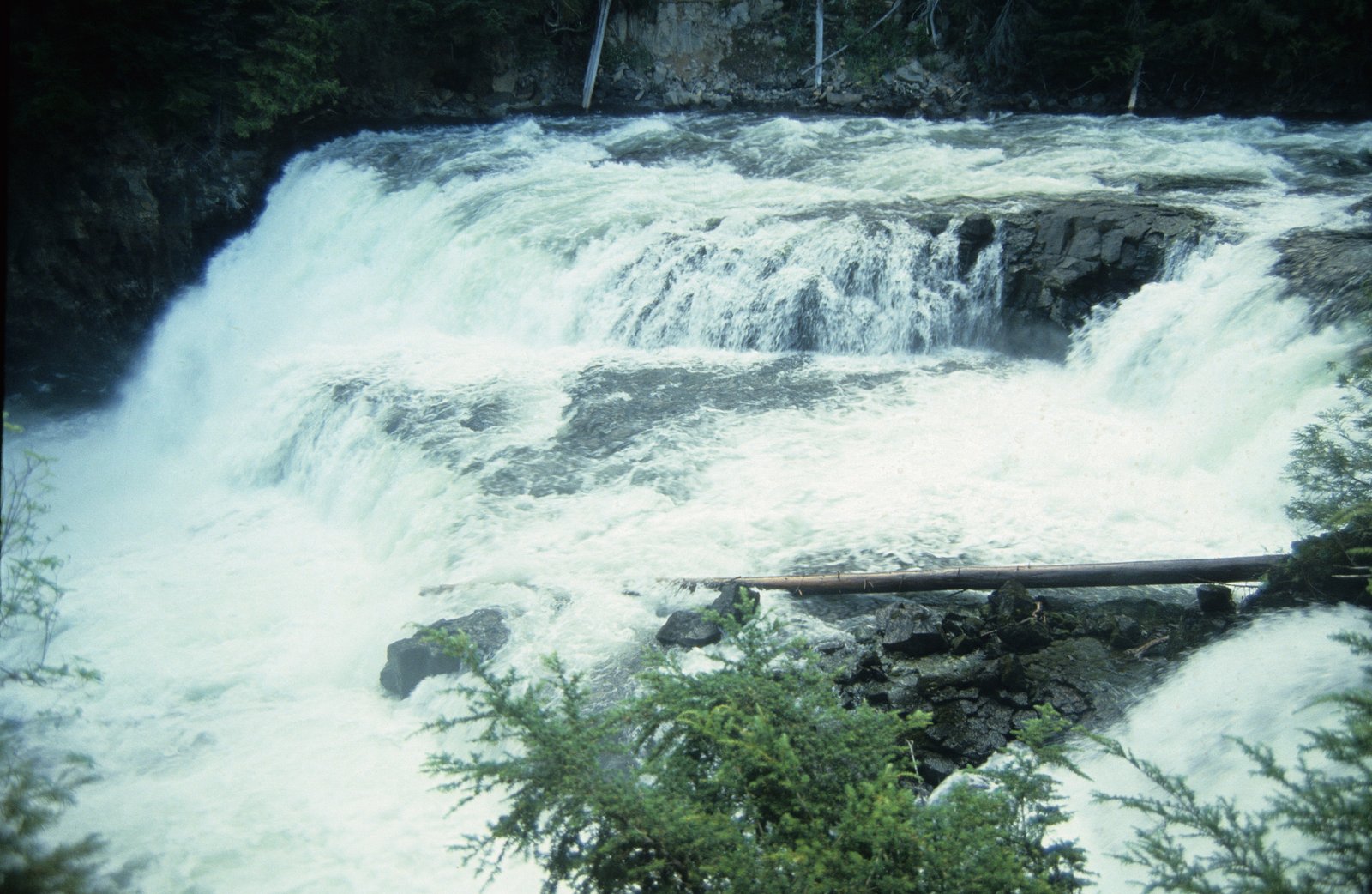
Why This Waterfall Exists
Windigo Falls flows over hard intrusive rock laid down over 2.5-2.8 billion years ago. These resistant rocks form a durable ledge that water cannot easily wear away, creating the falls where softer material downstream has already eroded.
Trail & Hike Details
Trail Description
No confirmed maintained trail description is available. Visitors should be prepared for rough, possibly indistinct paths or short scrambles to reach viewpoints. Terrain near the water likely includes wet rock, roots, and uneven surfaces. If accessing by canoe or kayak, there may be portages or short shoreline walks. Expect a remote backcountry approach rather than a developed promenade.
What to Expect
A remote, natural waterfall with variable flow depending on season. Spring snowmelt typically increases flow and turbidity. Surrounding landscape is boreal forest with rocky shorelines and possible small cliffs or cascades. Limited or no facilities (no restrooms, signage, or maintained viewpoints). Poor or no cellular reception is likely. Insects (black flies, mosquitoes) can be significant at certain times of year.
Accessibility
No confirmed accessible infrastructure. Terrain and approach are likely unsuitable for visitors with limited mobility without specialized assistance.
Frequently Asked Questions
🐶 Are Dogs Allowed at Windigo Falls?
❌ Dogs are not allowed
Are There Any Fees or Permits Required?
🆖 No fees required
🏊 Is There Swimming at Windigo Falls?
❌ Swimming is not allowed
When to Visit
Late spring (snowmelt) for highest flows and dramatic water; summer for easier access and warmer weather; early fall for color and lower crowds. Winter visits are possible where legal and safe, but would require appropriate winter travel skills and equipment and carry additional hazards (ice, extreme cold).
Seasonal Access
The best time to visit is Spring, Summer, and Fall. Winter access may be limited. Check with the managing park or local authority for current conditions.
Safety Information
This location appears to be remote and may have unmaintained approaches. Hazards to plan for include slippery rocks and steep banks near the water, sudden changes in water level (especially during spring runoff), unstable shorelines, limited or no cell coverage, rough or gated roads, biting insects, ticks, and wildlife encounters (including bears). Tell someone your plans, carry navigation aids and a means of emergency communication, and avoid getting too close to the edge of wet or icy rock. If crossing rivers or streams, evaluate water conditions carefully, currents can be stronger than they appear.
Current Water Conditions
34.4 m³/s
Current discharge — how much water is flowing
Lower than usual for this time of year
Based on 63 years of record
29.01 m
Water depth at gauge
7-Day Discharge Trend
What does this mean for your visit?
Flow is lower than usual for this time of year.
About This Gauge
7-Day Flow Outlook
Based on the WSC gauge STURGEON RIVER AT MCDOUGALL MILLS (6 km away).
Today
Low
34 m³/s
5/10Tomorrow
Moderate
36 m³/s
5/10Tue
Moderate
34 m³/s
6/10Wed
Moderate
35 m³/s
5/10Thu
Moderate
37 m³/s
5/10Fri
Moderate
34 m³/s
8/10Sat
Moderate
34 m³/s
5/10Best window: Fri — moderate flow, mainly sunny (trip score 8/10).
Best time of year: this gauge typically runs highest from early May to late July, peaking in May.
How we calculate this
This is a transparent outlook, not a precise forecast. We take the waterfall's current flow strength (how it ranks against its historical normal for today, from the nearest WSC stream gauge), carry that ranking forward along the gauge's seasonal curve, and nudge it for forecast rain. Confidence is highest for the next day or two and falls further out. Always check official conditions and your own judgment before visiting — high flows can be dangerous.
Weather Forecast
Location & Access
Getting There
The falls sit in a remote, forested part of northern Ontario. Expect to reach the general area by driving on provincial or secondary roads followed by gravel or logging roads, or by canoe/kayak on local rivers/lakes if applicable. Road conditions may be rough and seasonal (gates, washouts); a high-clearance vehicle may be required. Exact access points and established trails are not confirmed. Consult local district office or provincial park/forest maps for up-to-date road and access information before travel.
Get Directions on Google MapsParking
No confirmed formal parking lot. If driving in, parking may be limited to informal pullouts on a logging or gravel road; obey signage and gates. If accessed by water, parking will be at the nearest legal access point or trailhead. Expect limited or no facilities.
Elevation
369 metres above sea level
Coordinates
50.215275° N, -91.522291° W
Visitor Tips & Gear
• Check local maps and contact the nearest provincial park/forest district office for current road and trail conditions before you go. • Use a high-clearance vehicle if driving on gravel/logging roads; watch for gates and private property. • Wear sturdy, waterproof footwear; expect wet and slippery rocks near the falls. • Carry insect repellent and long sleeves in spring/early summer. • Bring a map, compass/GPS, and extra water; cell service may be unreliable. • Practice Leave No Trace: pack out all garbage and avoid disturbing shoreline vegetation. • If traveling in bear country, carry bear spray and know how to use it; store food properly.
Where to Stay
Browse vacation cabins and private rentals nearby
Unique outdoor stays — tents, yurts, and treehouses
Rent a campervan or RV for your waterfall road trip
Some links are affiliate links. We may earn a commission at no extra cost to you.
Additional Information
Nearby Attractions
The broader region typically contains other rivers, lakes, backcountry canoe routes, and scenic shoreline areas. Specific nearby named attractions are not confirmed for these coordinates; consult regional maps for provincial parks, lookouts, and additional waterfalls in the area.
Wildlife
Typical boreal species may include moose, black bear, wolves, beavers, otters, and a variety of birds (raptors, waterfowl, songbirds). Ticks and biting insects can be common in warmer months.
Nearby Waterfalls
Writing about Windigo Falls? Embed this waterfall on your site for free.