Whispering Falls
By Armen Suny · Last verified Jun 2026
Difficulty
Drive Up
Trail Length
0.2 km
About Whispering Falls
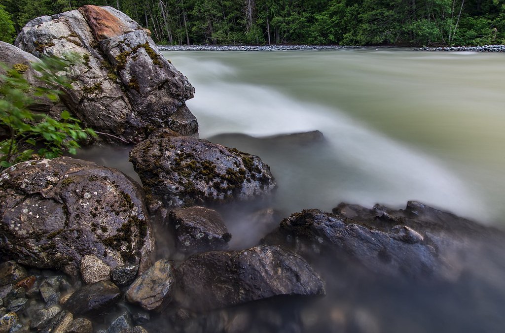
Whispering Falls is a lesser-known cascade in the Interior of British Columbia, located roughly 35–40 miles from Lillooet (coordinates: 50.4874, -122.6267). It appears to be a relatively small to moderate cascade set in a steep, forested valley. Flow is typically highest in late spring and early summer during snowmelt and after heavy rain. The site is not a developed or staffed day-use area; access is likely via a combination of paved highway and unpaved forest/side roads with an unmarked or informal approach trail. Specific published descriptions and official trail documentation for Whispering Falls at these coordinates are limited, so some details below are conservative estimates.
The Setting
Whispering Falls sits at 967 metres within Wildlife Habitat Areas, in the mountains of British Columbia.
Why This Waterfall Exists
Whispering Falls flows over layered sedimentary rock laid down about 66-201 million years ago. These soft rocks erode readily, allowing the stream to carve a vertical drop into the landscape.
Nearby Falls Worth Visiting
Place Creek Falls (122 m) lies 2.7 kilometres to the southwest.
Trail & Hike Details
The Approach
No hiking required. Whispering Falls is accessible by vehicle with a roadside viewing area.
Trail Description
There may be only an informal, unmarked approach to the falls consisting of a short scramble or single-track through forest and over rocky ground. Expect uneven footing, roots, and possibly a short steep section or rock scramble to reach viewpoints. Stream or side-channel crossings may be required. Because authoritative guide descriptions are scarce, treat route-finding as part of the experience and prepare for off-trail travel.
What to Expect
A natural, undeveloped waterfall setting in a steep, forested canyon. Expect mossy rocks, limited established viewpoints, and potentially high flows in spring. There are likely no facilities, no interpretive signs, and limited or no cell coverage. Conditions can be wet and slippery; the fall may be more a series of cascades than a single large plunge depending on season.
Accessibility
This waterfall is viewable from a vehicle-accessible area. No hiking is required.
Frequently Asked Questions
🐶 Are Dogs Allowed at Whispering Falls?
❌ Dogs are not allowed
Are There Any Fees or Permits Required?
🆖 No fees required
🏊 Is There Swimming at Whispering Falls?
❌ Swimming is not allowed
When to Visit
Late spring to early summer for strongest flows (snowmelt). Mid to late summer may offer easier access and more stable footing but lower flow. Fall can be scenic with color but may bring more rain and earlier snow at higher elevations. Winter access is likely difficult or unsafe due to snow, ice, and avalanche risk, and is not recommended unless you are experienced and properly equipped.
Seasonal Access
The best time to visit is Spring, Summer, and Fall. Winter access may be limited. Check with the managing park or local authority for current conditions.
Safety Information
Hazards include slippery rocks, steep or unstable slopes, sudden high water during rain or snowmelt, limited or no cell service, and wildlife encounters. Do not climb wet rock faces near the falls. Avoid getting too close to edges; submerged hazards and strong currents can be present. Check road and weather conditions before visiting and tell someone your plan and expected return time.
Current Water Conditions
254.0 m³/s
Current discharge — how much water is flowing
Lower than usual for this time of year
Based on 105 years of record
3.38 m
Water depth at gauge
7-Day Discharge Trend
What does this mean for your visit?
Flow is lower than usual for this time of year.
About This Gauge
This gauge is on a nearby waterway and may not reflect exact conditions at the falls.
7-Day Flow Outlook
Based on the WSC gauge LILLOOET RIVER NEAR PEMBERTON (21 km away).
Today
Moderate
276 m³/s
5/10Tomorrow
Moderate
259 m³/s
6/10Tue
Moderate
247 m³/s
8/10Wed
Moderate
250 m³/s
6/10Thu
Moderate
245 m³/s
6/10Fri
Moderate
262 m³/s
5/10Sat
Moderate
254 m³/s
6/10Best window: Tue — moderate flow, mainly sunny (trip score 8/10).
Best time of year: this gauge typically runs highest from early June to late August, peaking in July.
How we calculate this
This is a transparent outlook, not a precise forecast. We take the waterfall's current flow strength (how it ranks against its historical normal for today, from the nearest WSC stream gauge), carry that ranking forward along the gauge's seasonal curve, and nudge it for forecast rain. Confidence is highest for the next day or two and falls further out. Always check official conditions and your own judgment before visiting — high flows can be dangerous.
Know when to go.
Get a free email alert when waterfalls near Lillooet hit peak flow. We only send when conditions are worth the trip — no weekly newsletters, no spam.
Weather Forecast
Location & Access
Getting There
From Lillooet, head generally southwest toward the Duffey Lake / Highway 99 corridor and use the provided coordinates (50.4874, -122.6267) in a GPS device or mapping app. Expect to leave the main highway onto a secondary or forest service road; the final approach may require high-clearance or 4x4 depending on conditions. Route-finding may be required; there may be no formal trailhead signage.
Get Directions on Google MapsParking
Parking is likely informal (shoulder pullout or small clearing). There is probably no established parking lot, vault toilet, or official facilities. Park off the road where safe and legal; avoid blocking gates or forestry equipment access.
Elevation
967 metres above sea level
Coordinates
50.487357° N, -122.626699° W
Land Management
Managed by Government of British Columbia
Visitor Tips & Gear
• Use the exact coordinates and offline maps/GPS for navigation; phone signal may be unreliable. • Wear sturdy, grippy footwear and expect slippery rock and muddy sections. • Bring a compass or offline map; do not rely solely on trail signage. • Check recent local trip reports or with regional forest service offices for current road and trail conditions before you go. • Practice Leave No Trace; pack out all waste. • Be bear-aware: make noise, carry bear spray and know how to use it. • If crossing streams, be cautious, flows can rise quickly after rain or during melt.
Where to Stay
Browse vacation cabins and private rentals nearby
Unique outdoor stays — tents, yurts, and treehouses
Rent a campervan or RV for your waterfall road trip
Some links are affiliate links. We may earn a commission at no extra cost to you.
Nearby Campground
Birkenhead Lake Provincial Campsite
8.7 km away
Additional Information
Nearby Attractions
Nearest town is Lillooet (roughly 30–40 miles away). Other regional attractions may include Duffey Lake corridor and various provincial parks along Highway 99, alpine lakes and backcountry hiking opportunities in the Coast Mountains. Exact nearby named attractions relative to these coordinates are not well-documented.
Wildlife
Black bears, deer, small mammals, raptors, and other interior-BC species may be present. Be alert for wildlife and take standard precautions (store food securely, make noise while hiking, carry bear spray).
Cities near Whispering Falls
Nearby Waterfalls
Other waterfalls named Whispering Falls
1 other waterfall shares this name across Canada.
Writing about Whispering Falls? Embed this waterfall on your site for free.