Wards falls
By Armen Suny · Last verified Jun 2026
Difficulty
Moderate
Trail Length
6.3 km
Trail Type
Out And Back
Elevation Gain
165 m
About Wards falls
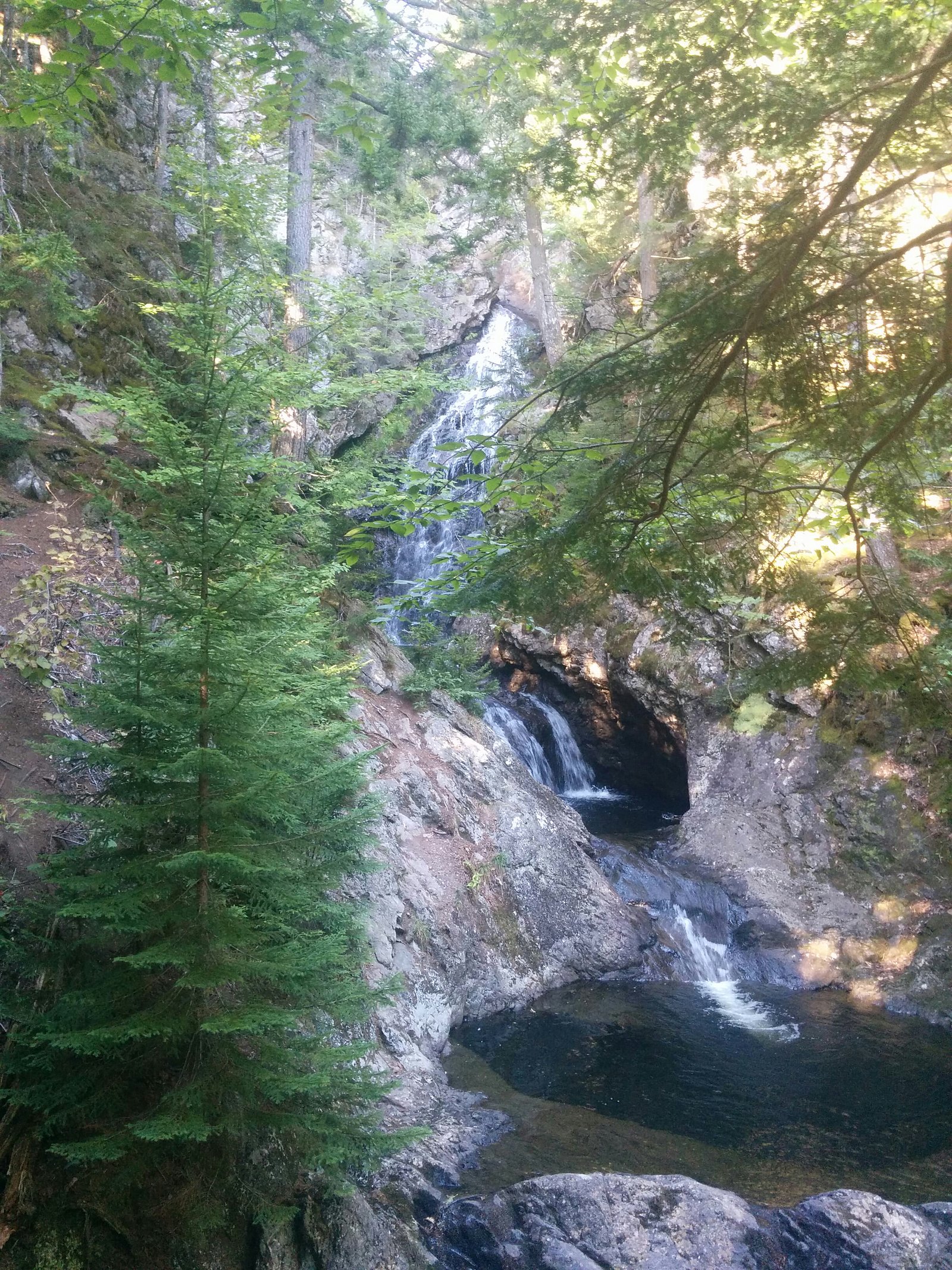
Wards Falls (coordinates 45.4475, -64.4194) is a small, locally known waterfall in western Nova Scotia. It sits in a wooded, rural setting and is most notable for seasonal flow changes (highest in spring and after rain). There does not appear to be a formal provincial park or major developed day-use site at the exact location; access is commonly via local roads and a short walk. Exact measured height and official naming details are not confirmed.
Why This Waterfall Exists
Wards falls flows over hard volcanic rock laid down about 299-419 million years ago. These resistant rocks form a durable ledge that water cannot easily wear away, creating the falls where softer material downstream has already eroded.
Trail & Hike Details
The Approach
The moderate 6.3-km out-and-back trail gains 165 metres of elevation on the way to the falls.
Trail Description
Trail/access information appears minimal or informal. Expect a short walk from a roadside parking area across uneven forest ground, roots and rocks. Trails may be unmarked and can include steep or slippery sections near the water. There may be no maintained boardwalks, railings, or official viewing platforms.
What to Expect
A modest, scenic cascade set in a mixed forest with rocky banks. Flow is seasonal, highest in spring and after rains and reduced in late summer or drought. Limited amenities: no toilets, picnic shelters, or visitor center. Cell service may be spotty in rural areas. The setting is natural and can be exposed to mud, slippery rock, and biting insects in warmer months.
Accessibility
The trail is not wheelchair accessible. Uneven terrain and elevation changes require steady footing.
Frequently Asked Questions
🐶 Are Dogs Allowed at Wards falls?
❌ Dogs are not allowed
Are There Any Fees or Permits Required?
🆖 No fees required
🏊 Is There Swimming at Wards falls?
❌ Swimming is not allowed
When to Visit
Spring (snowmelt and rainy season) for strongest flows and late fall for colors; early morning or weekdays for fewer visitors. Avoid visiting after heavy rains or rapid thaws if concerned about strong currents or unstable banks.
Seasonal Access
The best time to visit is Spring, Summer, and Fall. Winter access may be limited. Check with the managing park or local authority for current conditions.
Safety Information
Hazards can include slippery rocks and trails, steep or unstable banks, strong currents after rain, cold water, and limited or no cell service. Watch footing near the water, avoid standing on wet rocks, and do not climb unstable cliffs. If the area is on or adjacent to private land, respect boundaries and posted warnings. Bring a companion when possible and inform someone of your plans.
Current Water Conditions
0.1 m³/s
Current discharge — how much water is flowing
Much lower than usual for this time of year
Based on 53 years of record
0.81 m
Water depth at gauge
7-Day Discharge Trend
What does this mean for your visit?
Flow is well below normal for this time of year, so the waterfall may be a trickle.
About This Gauge
This gauge is on a nearby waterway and may not reflect exact conditions at the falls.
7-Day Flow Outlook
Based on the WSC gauge KELLEY RIVER (MILL CREEK) AT EIGHT MILE FORD (16 km away).
Today
Barely Flowing
0.1 m³/s
3/10Tomorrow
Barely Flowing
0.1 m³/s
4/10Tue
Barely Flowing
0.1 m³/s
4/10Wed
Barely Flowing
0.1 m³/s
3/10Thu
Barely Flowing
0.1 m³/s
4/10Fri
Barely Flowing
0.1 m³/s
4/10Sat
Barely Flowing
0.1 m³/s
3/10Best window: Tomorrow — barely flowing flow, cloudy (trip score 4/10).
Best time of year: this gauge typically runs highest from late March to early May, peaking in April.
How we calculate this
This is a transparent outlook, not a precise forecast. We take the waterfall's current flow strength (how it ranks against its historical normal for today, from the nearest WSC stream gauge), carry that ranking forward along the gauge's seasonal curve, and nudge it for forecast rain. Confidence is highest for the next day or two and falls further out. Always check official conditions and your own judgment before visiting — high flows can be dangerous.
Know when to go.
Get a free email alert when waterfalls near Amherst hit peak flow. We only send when conditions are worth the trip — no weekly newsletters, no spam.
Weather Forecast
Location & Access
Getting There
The falls are located in western Nova Scotia approximately 27.5 miles from Amherst, 35.5 miles from Windsor, and 47.7 miles from Moncton (coordinates above). Access is typically by local secondary/forestry roads and then on foot; there may be little or no signage. Use the GPS coordinates to navigate and be prepared for an unmarked trailhead or roadside pull-off.
Get Directions on Google MapsParking
Parking may be informal, a roadside pull-off or small, unmarked lot. Capacity is likely very limited. Do not block driveways or gates; respect posted private property signs.
Elevation
121 metres above sea level
Coordinates
45.447490° N, -64.419366° W
Visitor Tips & Gear
• Use GPS coordinates and local maps, signage may be minimal. • Wear sturdy, grippy footwear; approach banks with caution (slippery rocks). • Bring insect repellent (black flies and mosquitoes can be prevalent in spring/summer). • Respect private property and posted signs; park only in safe, legal areas. • Check weather and recent local reports before visiting; recent rain can significantly change stream flow and hazards. • Leave no trace: pack out all trash.
As an Amazon Associate, we earn from qualifying purchases.
With 6.3 km and 165 m of elevation gain, sturdy boots and trekking poles will help on this moderate trail. Sun exposure on the trail makes good sun protection a must in summer.

Columbia Watertight II Rain Jacket
Packs into its own pocket, seam-sealed, and keeps you dry from spray and surprise rain.

Earth Pak Waterproof Dry Bag
Keeps your phone and gear dry when waterfall mist soaks everything else.

Waterproof Phone Pouch (AiRunTech)
Cheap insurance — take photos right next to the falls without killing your phone.

Timberland Euro Sprint Mid Waterproof
Trusted waterproof boot with premium leather and grippy rubber sole — reliable on rocky, wet trails.

TrailBuddy Trekking Poles
Lightweight aluminum, cork grips, and flip-locks that actually hold — a best-seller for good reason.

Sawyer Squeeze Water Filter
The backcountry standard — filters 99.9% of bacteria and weighs just 3 oz.
Where to Stay
Browse vacation cabins and private rentals nearby
Unique outdoor stays — tents, yurts, and treehouses
Rent a campervan or RV for your waterfall road trip
Some links are affiliate links. We may earn a commission at no extra cost to you.
Nearby Campground
Glooscap Campground & RV
13.7 km away
Additional Information
Nearby Attractions
Nearby towns include Amherst, Windsor, and Moncton (New Brunswick). Visitors often combine a short waterfall visit with exploring local coastal parks, historic sites, and regional trails, check local tourism resources for current attractions and services.
Wildlife
Typical regional wildlife may include white-tailed deer, small mammals, songbirds, waterfowl, and possibly moose or black bear in more remote areas. Ticks and biting insects can be common in warmer months. Observe wildlife from a distance.
Cities near Wards falls
Nearby Waterfalls
Writing about Wards falls? Embed this waterfall on your site for free.