Photo Credits (5)
Difficulty
Moderate
Trail Length
5.0 km
Trail Type
Out And Back
Elevation Gain
204 m
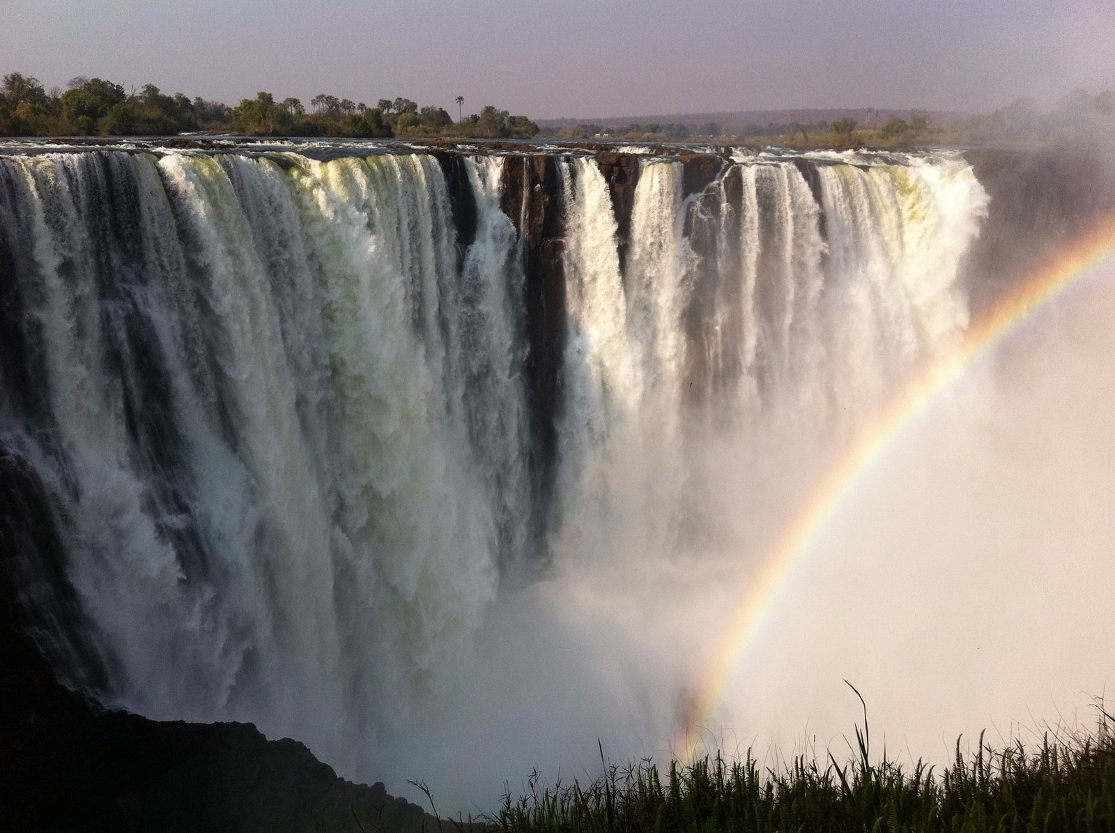
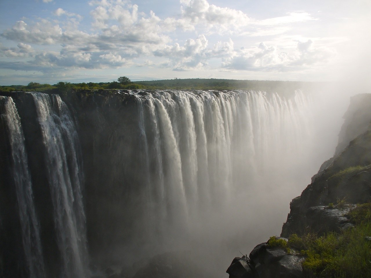
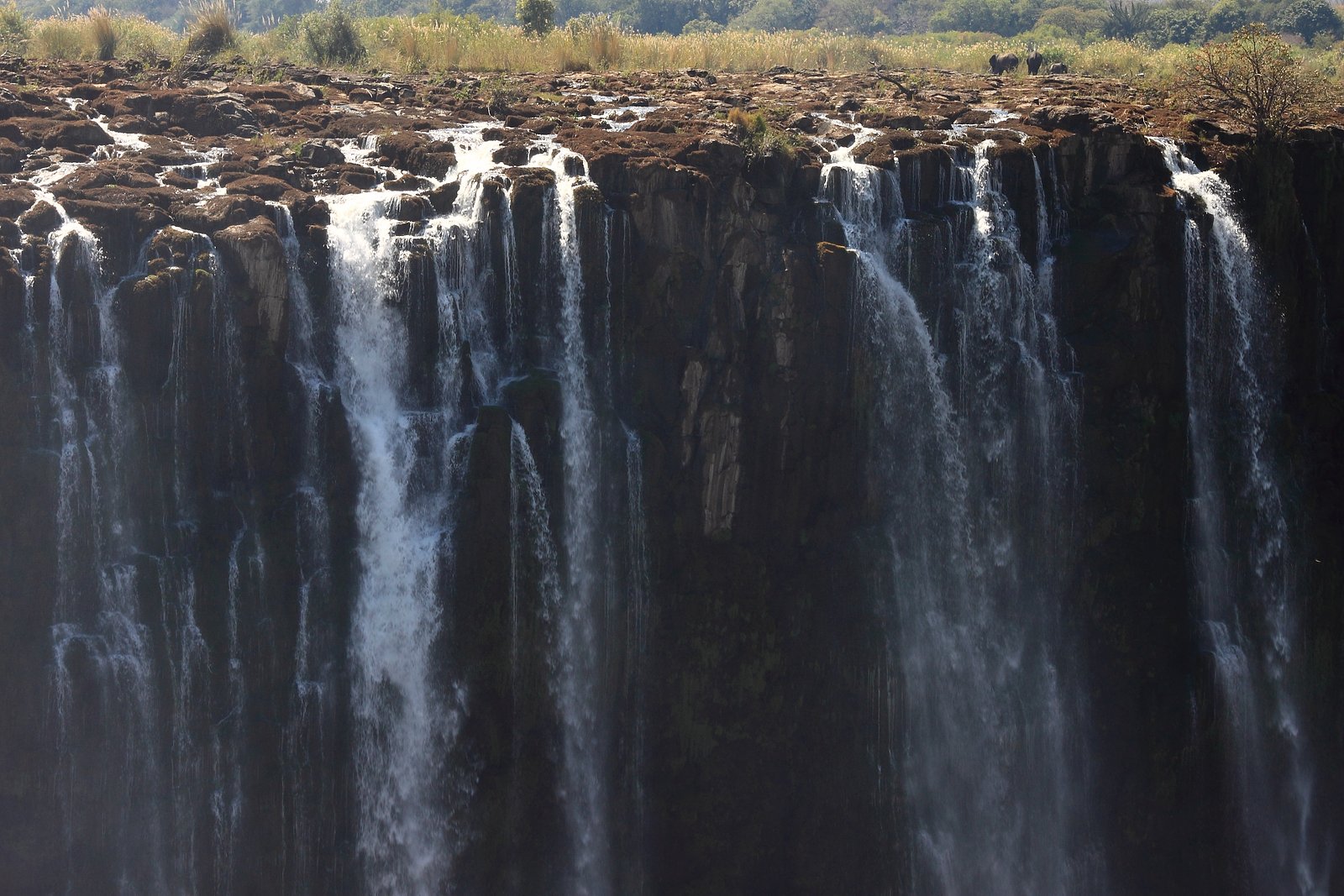
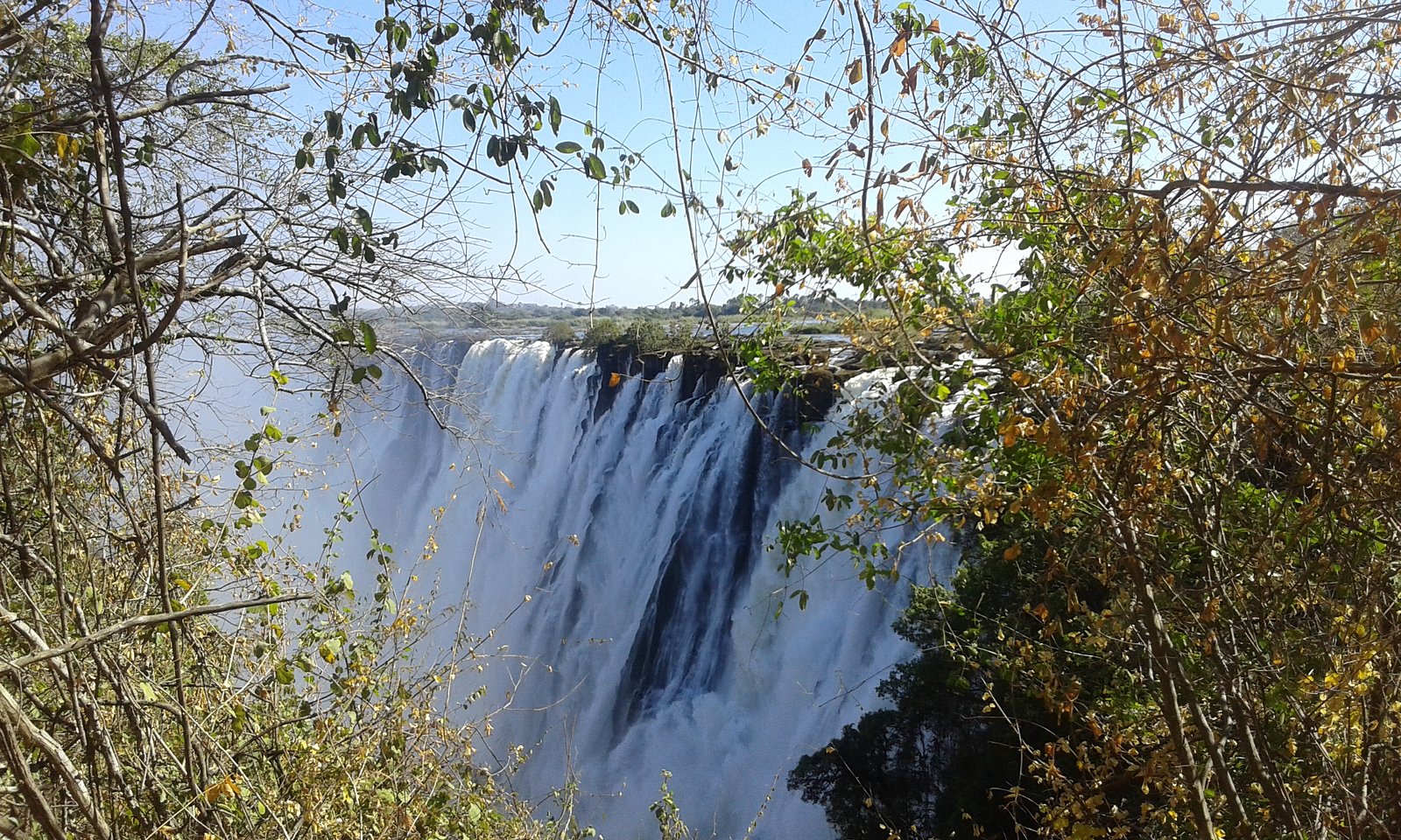
About Victoria Falls
Victoria Falls (Ontario) is a small, scenic cascade on a local creek/river within the Oro-Medonte / Severn/Simcoe region near Orillia. The site is typically accessed from a short trail and offers views of multi-tiered drops and wooded riverbanks. Specific historical and hydrological details vary by source; descriptions here are general and may be approximate.
The Setting
Victoria Falls sits at 270 metres within Queen Elizabeth II Wildlands Provincial Park (Natural Environment Class), in the foothills of Ontario.
Why This Waterfall Exists
Victoria Falls flows over hard crystalline rock, primarily gneiss, laid down over 1.0-1.6 billion years ago. These resistant rocks form a durable ledge that water cannot easily wear away, creating the falls where softer material downstream has already eroded.
Trail & Hike Details
The Approach
The moderate 5.0-km out-and-back trail gains 204 metres of elevation on the way to the falls.
Trail Description
Expect a short, generally well-worn trail through mixed hardwood forest to one or more overlooks above the stream. The path may include roots, rocks, and short stair or boardwalk sections in wetter spots. Trail surfaces can be muddy after rain or during spring melt. Several vantage points may be available to view the cascade from above; access to the riverbank or base of the falls may be steep and slippery and could be restricted.
What to Expect
A modest cascade with wooded surroundings, seasonal variation in water flow (typically highest in spring). Wildlife such as songbirds, waterfowl, deer, and beavers may be present nearby. The site can be quiet on weekdays but busier on summer weekends. In winter the falls may form ice features and the trail can be icy.
Accessibility
The trail is not wheelchair accessible. Uneven terrain and elevation changes require steady footing.
Frequently Asked Questions
🐶 Are Dogs Allowed at Victoria Falls?
❌ Dogs are not allowed
Are There Any Fees or Permits Required?
🆖 No fees required
🏊 Is There Swimming at Victoria Falls?
❌ Swimming is not allowed
When to Visit
Spring for highest flows and dramatic water levels; fall for foliage and cooler weather; summer for easier hiking access (but potentially lower flows); winter for frozen scenery but increased risk of icy trails. Early morning or weekday visits reduce crowds.
Seasonal Access
The best time to visit is Spring, Summer, Fall, and Winter. Check with the managing park or local authority for current conditions.
Safety Information
Primary hazards: slippery wet rocks, unstable or undercut banks, seasonal high water and strong currents during spring melt or after heavy rain, icy trails in winter, ticks and biting insects, and limited cell service in some rural areas. Do not approach or stand on wet rocks at the edge of the falls. Supervise children closely. If unsure about conditions, avoid risky route sections and consult local authorities.
Current Water Conditions
0.9 m³/s
Current discharge — how much water is flowing
About average for this time of year
Based on 10 years of record
8.99 m
Water depth at gauge
7-Day Discharge Trend
What does this mean for your visit?
Flow is about average for this time of year.
About This Gauge
This gauge is on a nearby waterway and may not reflect exact conditions at the falls.
7-Day Flow Outlook
Based on the WSC gauge HEAD RIVER NEAR SEBRIGHT (12 km away).
Today
Moderate
1.0 m³/s
8/10Tomorrow
Moderate
1.0 m³/s
6/10Tue
Moderate
1.3 m³/s
6/10Wed
Moderate
1.2 m³/s
6/10Thu
Moderate
0.9 m³/s
6/10Fri
Moderate
0.8 m³/s
5/10Sat
Moderate
0.8 m³/s
6/10Best window: Today — moderate flow, mainly sunny (trip score 8/10).
Best time of year: this gauge typically runs highest from mid March to late April, peaking in April.
How we calculate this
This is a transparent outlook, not a precise forecast. We take the waterfall's current flow strength (how it ranks against its historical normal for today, from the nearest WSC stream gauge), carry that ranking forward along the gauge's seasonal curve, and nudge it for forecast rain. Confidence is highest for the next day or two and falls further out. Always check official conditions and your own judgment before visiting — high flows can be dangerous.
Know when to go.
Get a free email alert when waterfalls near Orillia hit peak flow. We only send when conditions are worth the trip — no weekly newsletters, no spam.
Weather Forecast
Location & Access
Getting There
Coordinates: 44.8328, -79.0594. The falls are located in the general Oro-Medonte / Severn Township area north of Barrie and west of Orillia. From Orillia (about 26.5 miles), Barrie (about 49.1 miles) or Peterborough (about 56.8 miles) follow local roads to the nearest public parking or conservation-area lot. Access is usually via a signed trailhead; exact driving directions and the best access point should be confirmed with local municipal or conservation authority resources.
Get Directions on Google MapsParking
There may be a small trailhead or roadside parking area close to the access point. Parking is likely limited and may be informal; use designated lots where provided and avoid blocking private driveways. Confirm parking rules locally.
Elevation
270 metres above sea level
Coordinates
44.832798° N, -79.059397° W
Land Management
Managed by Ontario Parks
Visitor Tips & Gear
Wear sturdy, grippy footwear, rocks and trails can be slippery. Stay on designated trails and respect private property. Expect limited or informal parking; carpool if possible. Watch for ticks and wear insect repellent in warm months. Avoid going onto wet rocks at the edge of the falls; currents and undercut banks can be hazardous. Check local conditions (trail reports or conservation authority) before visiting.
As an Amazon Associate, we earn from qualifying purchases.
With 5.0 km and 204 m of elevation gain, sturdy boots and trekking poles will help on this moderate trail. Icy conditions are common in winter — traction cleats are a smart addition.

Columbia Watertight II Rain Jacket
Packs into its own pocket, seam-sealed, and keeps you dry from spray and surprise rain.

Polarized Sunglasses (Knockaround)
Cuts glare off the water so you actually see the falls — and your photos turn out better too.

Earth Pak Waterproof Dry Bag
Keeps your phone and gear dry when waterfall mist soaks everything else.

Waterproof Phone Pouch (AiRunTech)
Cheap insurance — take photos right next to the falls without killing your phone.

Timberland Euro Sprint Mid Waterproof
Trusted waterproof boot with premium leather and grippy rubber sole — reliable on rocky, wet trails.

TrailBuddy Trekking Poles
Lightweight aluminum, cork grips, and flip-locks that actually hold — a best-seller for good reason.
Where to Stay
Browse vacation cabins and private rentals nearby
Unique outdoor stays — tents, yurts, and treehouses
Rent a campervan or RV for your waterfall road trip
Some links are affiliate links. We may earn a commission at no extra cost to you.
Nearby Campground
Site 10
1.8 km away
Additional Information
Nearby Attractions
Orillia (recreational lakes and downtown), Couchiching shoreline, local conservation areas and provincial parks in Simcoe County, Mount St. Louis Moonstone (ski area) and Minesing Wetlands. Confirm exact nearby points of interest with a regional map.
Wildlife
Common regional wildlife may include white-tailed deer, beaver, muskrat, waterfowl, songbirds, and small mammals. Ticks are present in warmer months; black bear sightings are uncommon but possible in broader rural areas.
Cities near Victoria Falls
Nearby Waterfalls
Other waterfalls named Victoria Falls
1 other waterfall shares this name across Canada.
Writing about Victoria Falls? Embed this waterfall on your site for free.