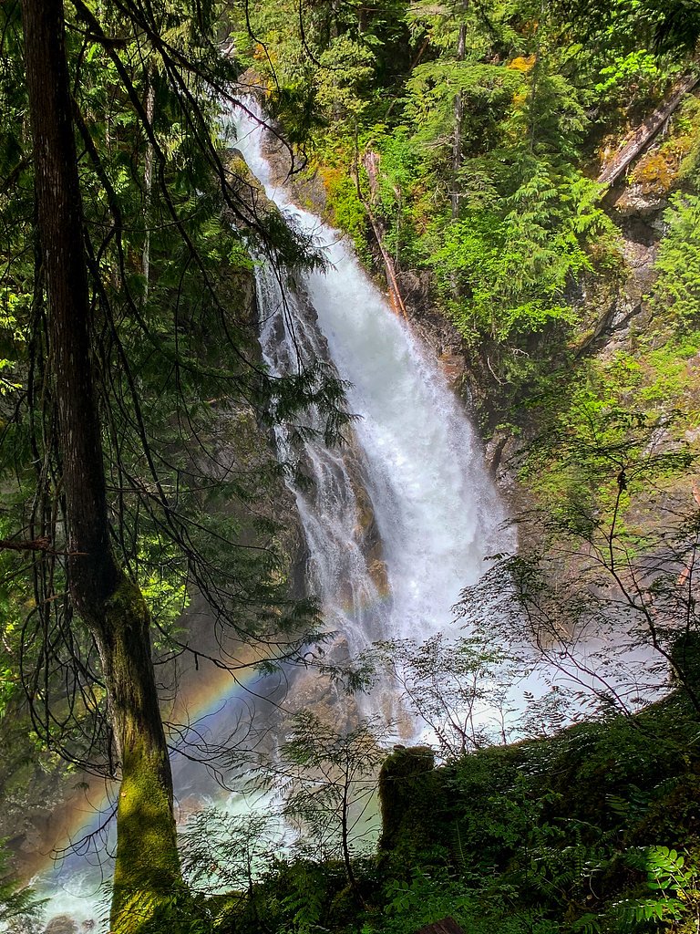
Upper Myra Falls
British Columbia • Strathcona Park • 23 m
By Armen Suny · Last verified Jun 2026
Difficulty
Moderate
Trail Length
7.4 km
Trail Type
Out And Back
Elevation Gain
296 m
About Upper Myra Falls
Upper Myra Falls is a multi-tiered cascade on Myra Creek located in Strathcona Provincial Park on Vancouver Island, British Columbia. The falls sit in a mossy, old-growth coastal forest with rocky ledges and pools. Access is from a trail off the Strathcona Park/Buttle Lake area; the setting is scenic and typically less developed than roadside waterfalls. Specific details (exact height and official measured statistics) vary between sources, so some measurements and conditions may be approximate.
The Setting
Upper Myra Falls sits at 520 metres within Strathcona Park, in the hills of British Columbia. The falls drop 23 metres.
Why This Waterfall Exists
Upper Myra Falls flows over Sicker Group, a hard volcanic rock layer deposited about 359-393 million years ago. These resistant rocks form a durable ledge that water cannot easily wear away, creating a 75-foot drop where softer material downstream has already eroded.
Nearby Falls Worth Visiting
Della Falls (440 m) lies 15.1 kilometres to the southeast. Also nearby: Lower Myra Falls (61 m, 6.1 km).
Trail & Hike Details
The Approach
The moderate 7.4-km out-and-back trail gains 296 metres of elevation on the way to the falls.
Trail Description
The trail to Upper Myra Falls passes through coastal temperate rainforest with ferns, moss-covered rocks and conifers. Expect a narrow, sometimes rooty or rocky path with short steep sections and wet surfaces near the creek. The route is typically an out-and-back to a viewpoint or streamside area above/below the main drop(s). Trails in this park can be muddy and may have uneven terrain; some visitors report stairs, built viewpoints or short boardwalks in sections, but portions may be rustic.
What to Expect
The falls drop 23 metres over hard volcanic rock.
Accessibility
The trail is not wheelchair accessible. Uneven terrain and elevation changes require steady footing.
Frequently Asked Questions
🐶 Are Dogs Allowed at Upper Myra Falls?
❌ Dogs are not allowed
Are There Any Fees or Permits Required?
🆖 No fees required
🏊 Is There Swimming at Upper Myra Falls?
❌ Swimming is not allowed
When to Visit
Late spring (snowmelt) and early summer often provide the strongest flows and lush scenery; fall offers color and fewer visitors. Winter access is possible but may be icy, snowy or hazardous, use caution and appropriate gear.
Seasonal Access
The best time to visit is Spring, Summer, Fall, and Winter. Check with Strathcona Park for current conditions.
Safety Information
Hazards include slippery wet rocks, steep drop-offs near cascades, strong currents in high water, hypothermia risk in cold water, limited cell reception, rapidly changing weather, and seasonal snow/ice. Use caution near edges, do not climb on wet ledges, and avoid crossing fast-flowing streams. If unsure about conditions, choose a safer viewpoint and check current park advisories.
Current Water Conditions
Based on a Water Survey of Canada gauge 31.5 km away
8.1 m³/s
Current discharge — how much water is flowing
About average for this time of year
Based on 44 years of record
4.27 m
Water depth at gauge
7-Day Discharge Trend
What does this mean for your visit?
Flow is about average for this time of year.
About This Gauge
This gauge is on a regional waterway. Conditions at the falls may differ, especially after local rain.
7-Day Flow Outlook
Based on the WSC gauge CRUICKSHANK RIVER NEAR THE MOUTH (31 km away).
Today
Moderate
8.1 m³/s
6/10Tomorrow
Moderate
7.6 m³/s
8/10Tue
Moderate
7.5 m³/s
6/10Wed
Moderate
7.9 m³/s
5/10Thu
Moderate
7.7 m³/s
6/10Fri
Moderate
7.5 m³/s
5/10Sat
Moderate
7.4 m³/s
5/10Best window: Tomorrow — moderate flow, sunny (trip score 8/10).
Best time of year: this gauge typically runs highest from mid April to early July, peaking in June.
How we calculate this
This is a transparent outlook, not a precise forecast. We take the waterfall's current flow strength (how it ranks against its historical normal for today, from the nearest WSC stream gauge), carry that ranking forward along the gauge's seasonal curve, and nudge it for forecast rain. Confidence is highest for the next day or two and falls further out. Always check official conditions and your own judgment before visiting — high flows can be dangerous.
Know when to go.
Get a free email alert when waterfalls near Tofino hit peak flow. We only send when conditions are worth the trip — no weekly newsletters, no spam.
Weather Forecast
Location & Access
Getting There
Upper Myra Falls is reached via Strathcona Provincial Park on Vancouver Island. From Campbell River/Courtney area drive the Strathcona Park/Buttle Lake access (Highway 28/Buttle Lake Road) toward Buttle Lake and follow signs for Myra Falls trailhead/Strathcona Park. The provided coordinates (49.5688, -125.6503) locate the falls in the Myra Creek watershed. Distances to nearby towns: Tofino ~31.8 miles, Courtenay ~33.1 miles, Campbell River ~38.8 miles (these are approximate driving distances).
Get Directions on Google MapsParking
There is typically a small trailhead parking area near the Myra Falls trail. Parking is limited and may fill on busy days; park only in designated spaces. Visitors should check BC Parks information for any seasonal parking changes, day-use requirements, or closures.
Elevation
520 metres above sea level
Coordinates
49.568834° N, -125.650290° W
Land Management
Managed by Government of British Columbia
Visitor Tips & Gear
• Wear sturdy, grippy footwear; trail and rocks near the falls are slippery.• Bring layers and rain protection, coastal weather changes quickly.• Arrive early on busy days to find parking.• Leave no trace; pack out all trash and avoid trampling vegetation.• Stay off wet rocks and cliff edges; strong currents and slippery surfaces are hazardous.• Check BC Parks or local sources for trail updates, seasonal closures, and safety advisories before you go.• Expect limited cell service, download maps or bring a physical map.
As an Amazon Associate, we earn from qualifying purchases.
With 7.4 km and 296 m of elevation gain, sturdy boots and trekking poles will help on this moderate trail. Icy conditions are common in winter — traction cleats are a smart addition.

Columbia Watertight II Rain Jacket
Packs into its own pocket, seam-sealed, and keeps you dry from spray and surprise rain.

Polarized Sunglasses (Knockaround)
Cuts glare off the water so you actually see the falls — and your photos turn out better too.

Earth Pak Waterproof Dry Bag
Keeps your phone and gear dry when waterfall mist soaks everything else.

Waterproof Phone Pouch (AiRunTech)
Cheap insurance — take photos right next to the falls without killing your phone.

Timberland Euro Sprint Mid Waterproof
Trusted waterproof boot with premium leather and grippy rubber sole — reliable on rocky, wet trails.

TrailBuddy Trekking Poles
Lightweight aluminum, cork grips, and flip-locks that actually hold — a best-seller for good reason.
Where to Stay
Browse vacation cabins and private rentals nearby
Unique outdoor stays — tents, yurts, and treehouses
Rent a campervan or RV for your waterfall road trip
Some links are affiliate links. We may earn a commission at no extra cost to you.
Nearby Campground
Arnica Lake Campsite
3.7 km away
Additional Information
Nearby Attractions
Buttle Lake, Lower Myra Falls (other falls on Myra Creek), Strathcona Provincial Park trails, remote backcountry routes and campgrounds in the park, viewpoints and scenic drives in the Strathcona/Buttle Lake area.
Wildlife
Typical coastal Vancouver Island wildlife: black bears, deer, cougars (rare), small mammals, and a variety of birds and amphibians. Practice wildlife awareness, store food securely and keep distance from animals.
Cities near Upper Myra Falls
Nearby Waterfalls
Writing about Upper Myra Falls? Embed this waterfall on your site for free.