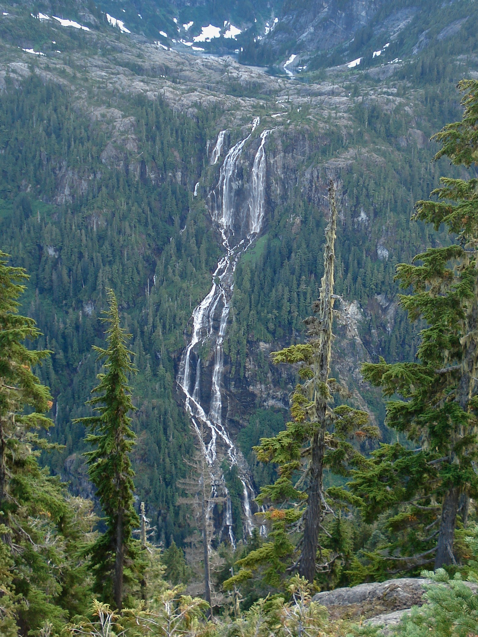
Della Falls
British Columbia • Strathcona Park • 440 m
By Armen Suny · Last verified Jun 2026
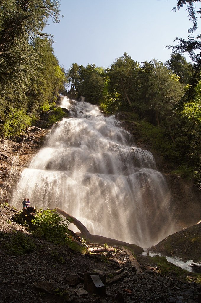
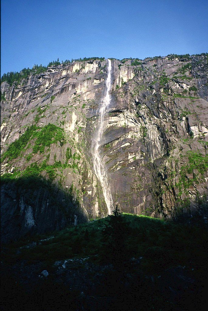

Photo Credits (4)
Difficulty
Moderate
Trail Length
32.0 km
Trail Type
Out And Back
Elevation Gain
540 m
About Della Falls
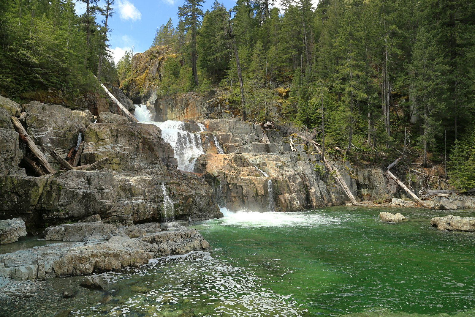
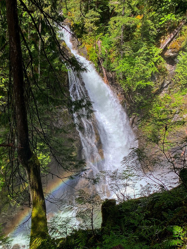
Della Falls is a waterfall located within Strathcona Provincial Park on Vancouver Island in British Columbia, Canada. With a total height of 440 m (1,440 ft), it ranks as the 16th tallest confirmed waterfall in Canada and the second tallest on Vancouver Island after Kiwi Falls in Schoen Lake Provincial Park.
The Setting
Della Falls sits at 1,030 metres within Strathcona Park, in the mountains of British Columbia. At 440 metres, it is among the taller waterfalls in British Columbia.
Why This Waterfall Exists
Della Falls flows over hard volcanic rock laid down about 252-419 million years ago. These resistant rocks form a durable ledge that water cannot easily wear away, creating a 1443-foot drop where softer material downstream has already eroded.
Nearby Falls Worth Visiting
Lower Myra Falls (61 m) lies 13.8 kilometres to the north. Also nearby: Upper Myra Falls (23 m, 15.1 km).
Trail & Hike Details
The Approach
The moderate 32.0-km out-and-back trail gains 540 metres of elevation on the way to the falls.
Trail Description
The approach to Della Falls is a remote backcountry route through coastal temperate rainforest, with muddy trails, roots, boardwalk sections in places, and river crossings. Many hikers arrange water taxi or floatplane service to shorten the approach; without boat/plane access the trip can add many kilometers and days. The last section into the falls typically descends into a narrow valley and may be steep and slippery. Most parties plan this as a multi-day backpacking trip with at least one overnight near the base of the falls. Trails can be rough, with blowdown after storms; expect routefinding and boggy terrain in places.
What to Expect
The falls plunge a dramatic 440 metres over hard volcanic rock.
Accessibility
The trail involves steep, uneven terrain with significant elevation change and is not accessible to mobility devices.
Frequently Asked Questions
🐶 Are Dogs Allowed at Della Falls?
❌ Dogs are not allowed
Are There Any Fees or Permits Required?
🆖 No fees required
🏊 Is There Swimming at Della Falls?
❌ Swimming is not allowed
When to Visit
Summer (July–September) generally offers the most stable weather and easiest hiking conditions. Spring (late May–June) often yields the highest flows but wetter, muddier trails and more challenging river crossings. Early fall can provide lower crowds and good weather, but conditions can change quickly. Winter travel is often hazardous due to snow, ice and limited daylight.
Seasonal Access
The best time to visit is Spring, Summer, and Fall. Winter access may be limited. Check with Strathcona Park for current conditions.
Safety Information
This is remote backcountry travel. Hazards include slippery and muddy trails, steep or unstable slopes near the falls, river crossings with strong currents (especially during high flow), rapid weather changes, cold water, limited or no cell service, and wildlife (black bears). Parties should be experienced in navigation, carry appropriate safety and emergency equipment (satellite communicator recommended), file a trip plan with someone reliable, and be prepared to turn back. Avoid cliff edges and unstable banks when viewing the falls. Check current conditions and closures with BC Parks before travel.
Current Water Conditions
0.6 m³/s
Current discharge — how much water is flowing
About average for this time of year
Based on 30 years of record
1.23 m
Water depth at gauge
7-Day Discharge Trend
What does this mean for your visit?
Flow is about average for this time of year.
About This Gauge
This gauge is on a nearby waterway and may not reflect exact conditions at the falls.
7-Day Flow Outlook
Based on the WSC gauge TOFINO CREEK NEAR THE MOUTH (23 km away).
Today
Moderate
0.6 m³/s
8/10Tomorrow
Moderate
0.6 m³/s
8/10Tue
Moderate
0.5 m³/s
6/10Wed
Moderate
0.5 m³/s
6/10Thu
Moderate
0.5 m³/s
5/10Fri
Moderate
0.4 m³/s
6/10Sat
Moderate
0.4 m³/s
5/10Best window: Today — moderate flow, mainly sunny (trip score 8/10).
Best time of year: this gauge typically runs highest from early November to mid November, peaking in October.
How we calculate this
This is a transparent outlook, not a precise forecast. We take the waterfall's current flow strength (how it ranks against its historical normal for today, from the nearest WSC stream gauge), carry that ranking forward along the gauge's seasonal curve, and nudge it for forecast rain. Confidence is highest for the next day or two and falls further out. Always check official conditions and your own judgment before visiting — high flows can be dangerous.
Know when to go.
Get a free email alert when waterfalls near Tofino hit peak flow. We only send when conditions are worth the trip — no weekly newsletters, no spam.
Weather Forecast
Location & Access
Getting There
Della Falls is in Strathcona Provincial Park on Vancouver Island. The GPS coordinates provided (49.4552, -125.5361) place the falls in the Bedwell River watershed area. The most common approach is to arrange boat or floatplane access across Great Central Lake (or nearby lakes) to a trailhead (often referenced as Love Lake / Bedwell Lake approaches) and then hike into the falls. From the nearest towns noted: Tofino ~31 mi, Courtenay ~34 mi, Campbell River ~39 mi (driving distances to trailhead access points vary). Access is remote; many parties use a commercial water taxi or floatplane to shorten the route. Always confirm current access options locally and with BC Parks.
Get Directions on Google MapsParking
Parking at public access points around Great Central Lake or at local launch areas is limited and may be informal. If using a commercial water taxi or floatplane, follow their instructions for vehicle parking. Expect limited oversight, and park at official lots where provided. Secure your vehicle and valuables, and verify parking rules with the operator or local land manager before leaving your car.
Elevation
1,030 metres above sea level
Coordinates
49.455244° N, -125.536112° W
Land Management
Managed by Government of British Columbia
Visitor Tips & Gear
• Arrange water taxi or floatplane in advance if you want to shorten travel time. • Plan for a multi-day trip; bring a tent and backcountry gear. • Check BC Parks and local operators for current trail conditions and any advisories. • Pack and store food properly, wildlife (black bears) occur in the park. • Bring waterproof clothing and footwear; trails are often muddy and wet. • Treat or filter water from natural sources. • Leave no trace: pack out all waste and avoid disturbing vegetation near fragile viewpoints.
As an Amazon Associate, we earn from qualifying purchases.
With 32.0 km and 540 m of elevation gain, sturdy boots and trekking poles will help on this moderate trail. Sun exposure on the trail makes good sun protection a must in summer.

Polarized Sunglasses (Knockaround)
Cuts glare off the water so you actually see the falls — and your photos turn out better too.

Columbia Watertight II Rain Jacket
Packs into its own pocket, seam-sealed, and keeps you dry from spray and surprise rain.

Earth Pak Waterproof Dry Bag
Keeps your phone and gear dry when waterfall mist soaks everything else.

Waterproof Phone Pouch (AiRunTech)
Cheap insurance — take photos right next to the falls without killing your phone.

Timberland Euro Sprint Mid Waterproof
Trusted waterproof boot with premium leather and grippy rubber sole — reliable on rocky, wet trails.

TrailBuddy Trekking Poles
Lightweight aluminum, cork grips, and flip-locks that actually hold — a best-seller for good reason.
Where to Stay
Browse vacation cabins and private rentals nearby
Unique outdoor stays — tents, yurts, and treehouses
Rent a campervan or RV for your waterfall road trip
Some links are affiliate links. We may earn a commission at no extra cost to you.
Nearby Campground
Della Falls Camp
0.5 km away
Additional Information
Nearby Attractions
Strathcona Provincial Park (trails, alpine lakes), Great Central Lake, Bedwell River valley, Elk River areas, hiking and canoeing opportunities elsewhere on Vancouver Island. Tofino and other west coast communities are a drive away for coastal access and services.
Wildlife
Black bears, cougars (rare), Roosevelt elk, deer, various birds (including bald eagles), and abundant insects. Be prepared for bear encounters and follow park guidance on food storage.
Cities near Della Falls
Nearby Waterfalls
Writing about Della Falls? Embed this waterfall on your site for free.