The Overfalls
Newfoundland and Labrador • Gros Morne National Park • 150 m
By Armen Suny · Last verified Jun 2026
Photo Credits (1)
Difficulty
Moderate
Trail Length
10.0 km
Trail Type
Out And Back
Elevation Gain
152 m
About The Overfalls
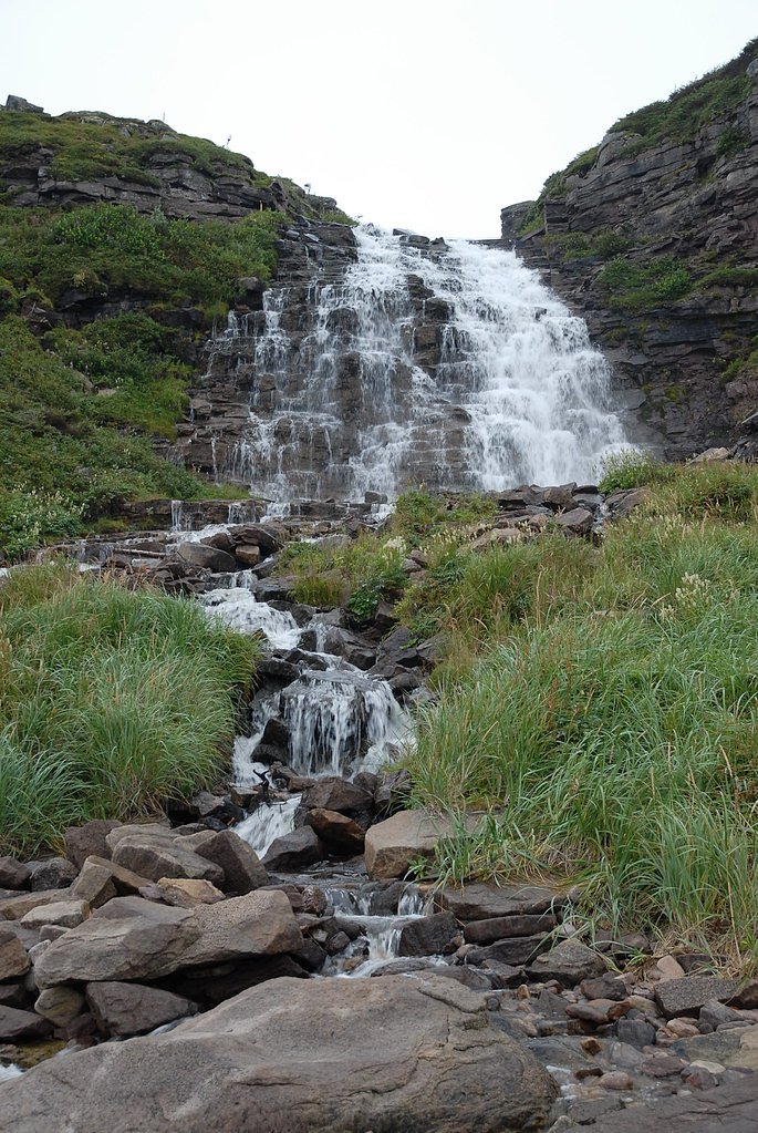
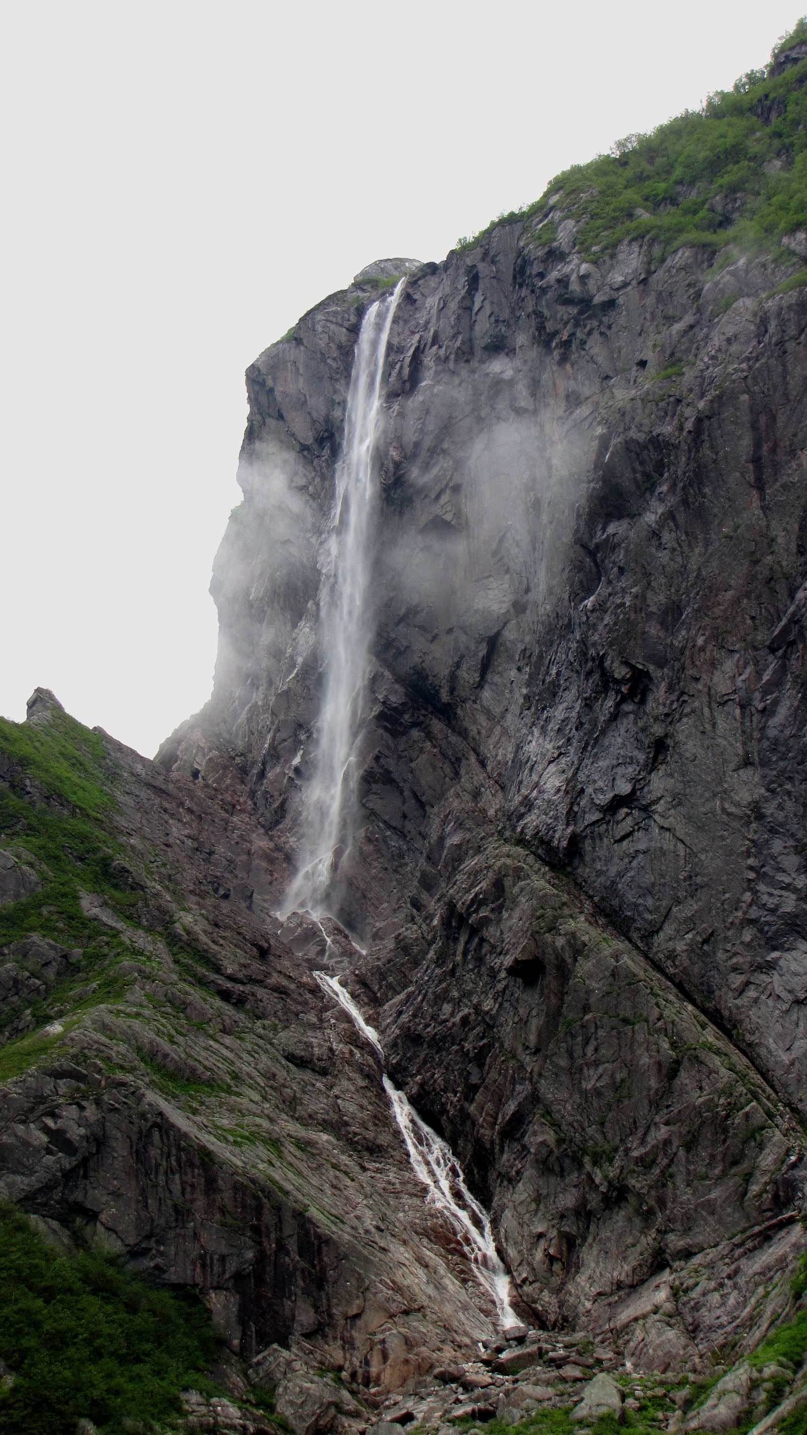
The Overfalls is a coastal/river waterfall feature located on the west side of Newfoundland, near Trout River and within driving distance of Deer Lake. The falls sit in a rugged coastal landscape where fresh water meets coastal terrain; local access is from rural roads and small pullouts. Specific published measurements and an official trail name are not widely documented; visitors report a short walk from a roadside parking area to viewpoints, with rocky and sometimes steep terrain near the water. Conditions can change seasonally and after storms.
The Setting
The Overfalls sits at 168 metres within Gros Morne National Park, in the foothills of Newfoundland and Labrador. At 150 metres, it is among the taller waterfalls in Newfoundland and Labrador.
Why This Waterfall Exists
The Overfalls flows over hard crystalline rock laid down over 1.4-1.8 billion years ago. These resistant rocks form a durable ledge that water cannot easily wear away, creating a 492-foot drop where softer material downstream has already eroded.
Nearby Falls Worth Visiting
Pissing Mare Falls, the tallest waterfall in Newfoundland and Labrador at 350 metres, lies 14.6 kilometres to the south.
Trail & Hike Details
The Approach
The moderate 10.0-km out-and-back trail gains 152 metres of elevation on the way to the falls.
Trail Description
Published, detailed trail guides for The Overfalls are limited. Visitor reports suggest a short walk from a roadside parking or pullout to one or more viewpoints overlooking the falls. Surfaces may be rocky, rooty, or uneven and can become slippery when wet or icy. There may be informal paths rather than a constructed boardwalk or maintained trail. Approach cautiously and be prepared for simple off-trail scrambling to reach better vantage points.
What to Expect
The falls plunge a dramatic 150 metres over hard crystalline rock.
Accessibility
The trail is not wheelchair accessible. Uneven terrain and elevation changes require steady footing.
Frequently Asked Questions
🐶 Are Dogs Allowed at The Overfalls?
❌ Dogs are not allowed
Are There Any Fees or Permits Required?
🆖 No fees required
🏊 Is There Swimming at The Overfalls?
❌ Swimming is not allowed
When to Visit
Late spring through early fall generally offers the best combination of water flow, safer walking conditions, and milder weather. Spring often has higher flows from snowmelt; summer provides more stable weather but possibly lower flows; fall offers good colors and cooler temperatures. Winter visits may be scenic but carry added hazards from ice, snow, and limited access.
Seasonal Access
The best time to visit is Spring, Summer, and Fall. Winter access may be limited. Check with Gros Morne National Park for current conditions.
Safety Information
Hazards can include slippery rocks, unstable edges, steep drop-offs, changing weather, tidal influence on coastal features, and limited cell reception. Do not approach unstable cliff edges, wear appropriate footwear, and avoid visiting alone in remote conditions. Exercise extra caution in winter due to ice and snow. Follow posted signs and local guidance.
Current Water Conditions
Based on a Water Survey of Canada gauge 33.8 km away
6.3 m³/s
Current discharge — how much water is flowing
About average for this time of year
Based on 39 years of record
0.66 m
Water depth at gauge
7-Day Discharge Trend
What does this mean for your visit?
Flow is about average for this time of year.
About This Gauge
This gauge is on a regional waterway. Conditions at the falls may differ, especially after local rain.
7-Day Flow Outlook
Based on the WSC gauge MAIN RIVER AT PARADISE POOL (34 km away).
Today
Moderate
6.8 m³/s
5/10Tomorrow
Moderate
6.6 m³/s
5/10Tue
Moderate
6.8 m³/s
5/10Wed
Moderate
6.3 m³/s
5/10Thu
Moderate
6.6 m³/s
5/10Fri
Moderate
6.0 m³/s
6/10Sat
Moderate
7.7 m³/s
5/10Best window: Fri — moderate flow, cloudy (trip score 6/10).
Best time of year: this gauge typically runs highest from mid April to late June, peaking in May.
How we calculate this
This is a transparent outlook, not a precise forecast. We take the waterfall's current flow strength (how it ranks against its historical normal for today, from the nearest WSC stream gauge), carry that ranking forward along the gauge's seasonal curve, and nudge it for forecast rain. Confidence is highest for the next day or two and falls further out. Always check official conditions and your own judgment before visiting — high flows can be dangerous.
Know when to go.
Get a free email alert when waterfalls near Trout River hit peak flow. We only send when conditions are worth the trip — no weekly newsletters, no spam.
Weather Forecast
Location & Access
Getting There
The Overfalls is located near coordinates 49.8426, -57.6286, roughly 38 miles from Trout River and about 40 miles from Deer Lake by road. Expect narrow rural highways and local access roads; follow local signs and consult a detailed map or GPS. If traveling from Deer Lake or Trout River, plan for a drive across local secondary roads and allow extra time for slow sections.
Get Directions on Google MapsParking
Parking is likely in a small roadside pullout or informal lot near the access point. Expect limited facilities (no formal lot, restrooms, or visitor center) and possibly uneven/gravel surfaces. Park clear of narrow road shoulders and follow any posted signs.
Elevation
168 metres above sea level
Coordinates
49.842572° N, -57.628600° W
Land Management
Managed by Parks Canada Agency
Visitor Tips & Gear
• Use caution near cliff edges and wet rocks, slippery conditions are common. • Wear sturdy, waterproof footwear and layered clothing; weather can change quickly. • Carry a map or GPS and inform someone of your plans; rural roads and cell coverage can be limited. • Leave no trace: pack out all trash and avoid disturbing vegetation and wildlife. • Check local signage and municipal or provincial websites for any advisories before visiting. • If bringing dogs, keep them on a leash and under control near cliffs and wildlife (local rules may apply).
As an Amazon Associate, we earn from qualifying purchases.
With 10.0 km and 152 m of elevation gain, sturdy boots and trekking poles will help on this moderate trail. Sun exposure on the trail makes good sun protection a must in summer.

Polarized Sunglasses (Knockaround)
Cuts glare off the water so you actually see the falls — and your photos turn out better too.

Columbia Watertight II Rain Jacket
Packs into its own pocket, seam-sealed, and keeps you dry from spray and surprise rain.

Earth Pak Waterproof Dry Bag
Keeps your phone and gear dry when waterfall mist soaks everything else.

Waterproof Phone Pouch (AiRunTech)
Cheap insurance — take photos right next to the falls without killing your phone.

Timberland Euro Sprint Mid Waterproof
Trusted waterproof boot with premium leather and grippy rubber sole — reliable on rocky, wet trails.

TrailBuddy Trekking Poles
Lightweight aluminum, cork grips, and flip-locks that actually hold — a best-seller for good reason.
Where to Stay
Browse vacation cabins and private rentals nearby
Unique outdoor stays — tents, yurts, and treehouses
Rent a campervan or RV for your waterfall road trip
Some links are affiliate links. We may earn a commission at no extra cost to you.
Nearby Campground
Triangle Pond
10.4 km away
Additional Information
Nearby Attractions
The area is within driving distance of attractions associated with western Newfoundland: coastal viewpoints and small fishing communities near Trout River, and Gros Morne National Park is in the broader region (verify distances and driving routes). Local scenic drives, picnic spots, and viewpoint pullouts are common in the region.
Wildlife
Visitors may encounter seabirds, shorebirds, waterfowl, and woodland species. Moose are present in parts of Newfoundland and may be encountered on roads or near trails; always keep distance. Marine life and seals may be seen along the coast. Be aware of seasonal bird nesting and other wildlife sensitivities.
Cities near The Overfalls
Nearby Waterfalls
Writing about The Overfalls? Embed this waterfall on your site for free.