Photo Credits (5)
Difficulty
Easy
Trail Length
2.6 km
Trail Type
Loop
Elevation Gain
68 m
About Stubb's Falls
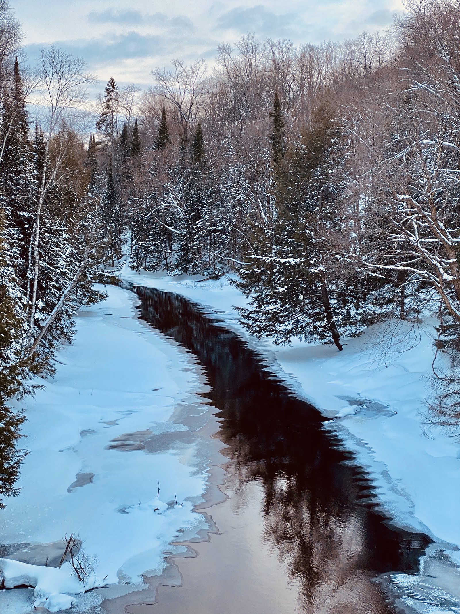
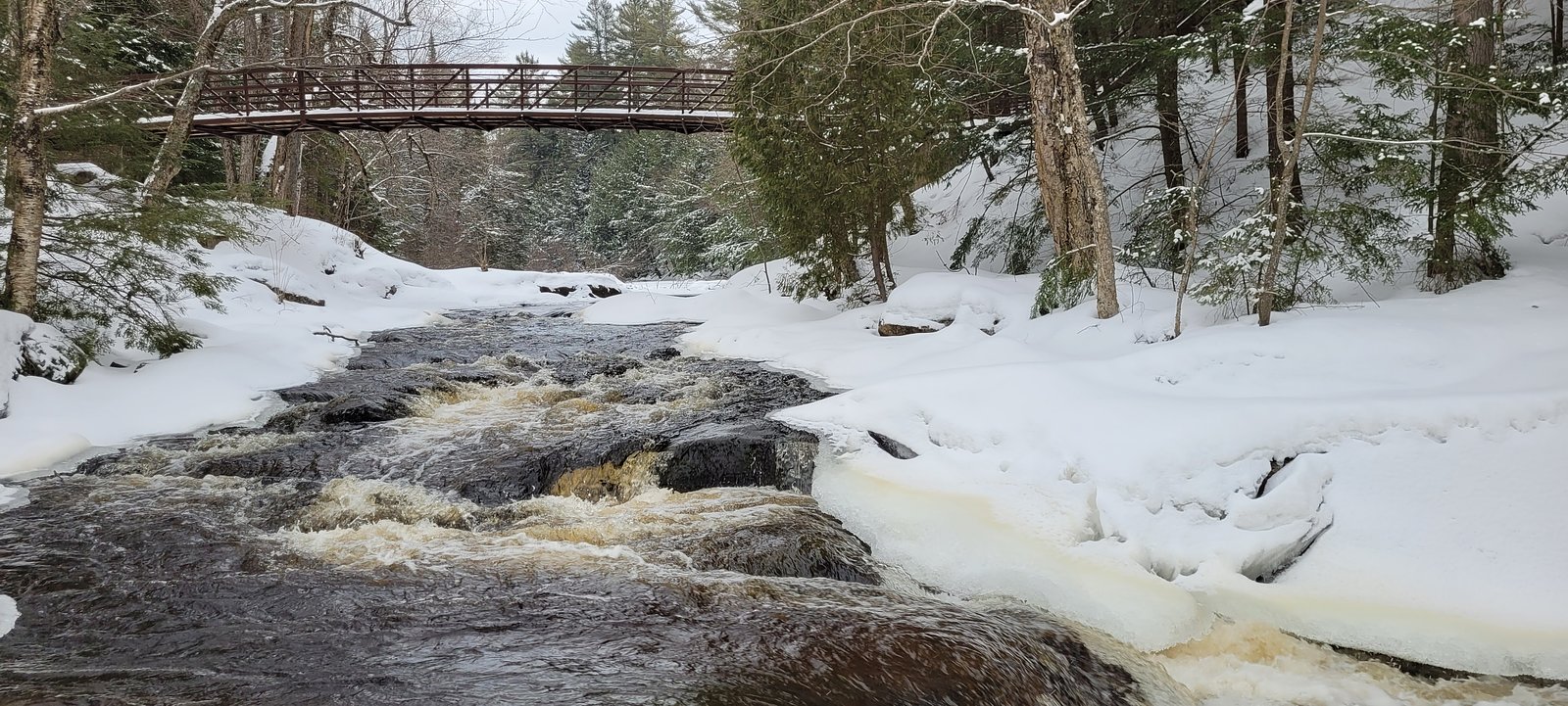
Stubb's Falls is a small, scenic cascade waterfall located in the Parry Sound region of Ontario (approx. coordinates 45.3829, -79.2092). Flows are typically highest in spring and after rain and lower in late summer. The site appears to be a natural, somewhat remote setting with limited formal infrastructure; specific official management (conservation authority or municipal) should be checked before visiting. Precise height and official measurements are not confirmed here.
The Setting
Stubb's Falls sits at 319 metres within Arrowhead Provincial Park (Natural Environment Class), in the foothills of Ontario.
Why This Waterfall Exists
Stubb's Falls flows over hard crystalline rock laid down over 1.4-1.8 billion years ago. These resistant rocks form a durable ledge that water cannot easily wear away, creating the falls where softer material downstream has already eroded.
Trail & Hike Details
The Approach
The easy 2.6-km loop trail gains 68 metres of elevation on the way to the falls.
Trail Description
Trail access to Stubb's Falls is typically via an unpaved or lightly maintained footpath through mixed forest. The path may include roots, rocks and short, potentially steep sections descending toward the stream and falls. There may be minimal signage or infrastructure. Trail conditions and markings vary by season and after storms; recent visitor reports or a local trail guide are recommended for the most current information.
What to Expect
A modest cascade or series of drops over bedrock with variable water flow depending on season and precipitation. Expect natural, rugged terrain near the stream with wet, slippery rocks and potentially steep banks. Facilities such as restrooms, picnic shelters, or lifeguards are unlikely. Cell phone reception can be spotty in parts of the area.
Accessibility
The trail is not wheelchair accessible. Uneven terrain and elevation changes require steady footing.
Frequently Asked Questions
🐶 Are Dogs Allowed at Stubb's Falls?
❌ Dogs are not allowed
Are There Any Fees or Permits Required?
🆖 No fees required
🏊 Is There Swimming at Stubb's Falls?
❌ Swimming is not allowed
When to Visit
Spring for highest flows and ice-melt runoff; early summer for accessible trails with full flows; fall for foliage and typically lower crowds. Avoid visiting immediately after heavy storms if possible due to fast, dangerous flows and unstable banks.
Seasonal Access
The best time to visit is Spring, Summer, and Fall. Winter access may be limited. Check with the managing park or local authority for current conditions.
Safety Information
Hazards include slippery and unstable rocks near the falls, sudden high water after rain, steep banks and drop-offs, limited or no facilities, and variable cell reception. Wear appropriate footwear, keep a safe distance from the edge, supervise children closely, and do not enter fast-moving water. Check local conditions and advisories before visiting and notify someone of your plans if going to a remote area.
Current Water Conditions
5.7 m³/s
Current discharge — how much water is flowing
About average for this time of year
Based on 52 years of record
5.33 m
Water depth at gauge
7-Day Discharge Trend
What does this mean for your visit?
Flow is about average for this time of year.
About This Gauge
7-Day Flow Outlook
Based on the WSC gauge BIG EAST RIVER NEAR HUNTSVILLE (4 km away).
Today
Moderate
5.6 m³/s
8/10Tomorrow
Moderate
5.5 m³/s
8/10Tue
Strong
6.1 m³/s
7/10Wed
Strong
5.7 m³/s
8/10Thu
Moderate
5.0 m³/s
8/10Fri
Strong
5.2 m³/s
8/10Sat
Moderate
4.8 m³/s
8/10Best window: Today — moderate flow, partly cloudy (trip score 8/10).
Best time of year: this gauge typically runs highest from late March to late May, peaking in April.
How we calculate this
This is a transparent outlook, not a precise forecast. We take the waterfall's current flow strength (how it ranks against its historical normal for today, from the nearest WSC stream gauge), carry that ranking forward along the gauge's seasonal curve, and nudge it for forecast rain. Confidence is highest for the next day or two and falls further out. Always check official conditions and your own judgment before visiting — high flows can be dangerous.
Know when to go.
Get a free email alert when waterfalls near Parry Sound hit peak flow. We only send when conditions are worth the trip — no weekly newsletters, no spam.
Weather Forecast
Location & Access
Getting There
The falls sit near 45.3829, -79.2092, roughly 37 miles from Parry Sound by road. Access generally requires driving on local/secondary roads and then walking a short distance on a trail or informal path. Exact turn-by-turn directions and road conditions can change seasonally; use the coordinates in a GPS app or consult local maps and recent visitor reports before traveling.
Get Directions on Google MapsParking
Parking appears to be limited to a small pullout or informal parking area near the trailhead. Spaces are likely few and may require on-road parking; avoid blocking gates or driveways. Expect no official large lot or maintained facilities.
Elevation
319 metres above sea level
Coordinates
45.382899° N, -79.209230° W
Land Management
Managed by Ontario Parks
Visitor Tips & Gear
• Wear sturdy, grippy footwear, rocks near the falls are often slippery. • Avoid stepping on wet bedrock or algae-covered stones; stay back from edges. • Pack out all trash; facilities are likely minimal or absent. • Check recent trip reports or contact local conservation/municipal authorities for trail and road conditions before visiting. • Be prepared for insects in summer and ticks in warm months; use repellent and check for ticks after hiking. • If parking is very limited, plan for alternates or visit during off-peak hours (weekday mornings).
As an Amazon Associate, we earn from qualifying purchases.
This easy 2.6 km hike is straightforward — comfortable trail shoes and plenty of water should do. Sun exposure on the trail makes good sun protection a must in summer.

Polarized Sunglasses (Knockaround)
Cuts glare off the water so you actually see the falls — and your photos turn out better too.

Columbia Watertight II Rain Jacket
Packs into its own pocket, seam-sealed, and keeps you dry from spray and surprise rain.

Earth Pak Waterproof Dry Bag
Keeps your phone and gear dry when waterfall mist soaks everything else.

Waterproof Phone Pouch (AiRunTech)
Cheap insurance — take photos right next to the falls without killing your phone.

JOBY GorillaPod Starter Kit
Wraps around railings and rocks for long-exposure waterfall shots — no flat surface needed.

Osprey Daylite Daypack
Light, organized, and just the right size for a day hike — fits water, snacks, and layers.
Where to Stay
Browse vacation cabins and private rentals nearby
Unique outdoor stays — tents, yurts, and treehouses
Rent a campervan or RV for your waterfall road trip
Some links are affiliate links. We may earn a commission at no extra cost to you.
Nearby Campground
Arrowhead Lake Campground
1 km away
Additional Information
Nearby Attractions
The broader Parry Sound region has lakes, Georgian Bay shoreline, and other trails and conservation areas. Check local visitor resources for nearby parks, viewpoints and services.
Wildlife
Expect typical Central Ontario wildlife: white-tailed deer, foxes, small mammals, a variety of bird species, and occasionally black bears. Ticks (Lyme disease risk) and mosquitoes are present in warmer months. Maintain distance from wildlife and store food securely.
Cities near Stubb's Falls
Nearby Waterfalls
Writing about Stubb's Falls? Embed this waterfall on your site for free.