Statlu Falls
By Armen Suny · Last verified Jun 2026
Difficulty
Hard
Trail Length
13.0 km
Trail Type
Out And Back
Elevation Gain
351 m
About Statlu Falls
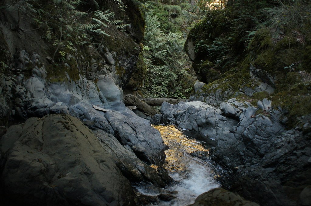
Statlu Falls (on Statlu Creek) is a steep, multi-tiered waterfall in the foothills west of Chilliwack, British Columbia. The falls drop into a narrow, rocky gorge and are most impressive in spring and early summer when snowmelt increases flow. Trail approaches pass through typical coastal-mountain second-growth forest and can be steep, muddy and slippery; viewpoints are often close to exposed edges with limited railings. Specific measurements for the total drop vary in sources and are not confirmed here.
The Setting
Statlu Falls sits at 609 metres within Old Growth Management Areas (Mapped Legal), in the hills of British Columbia.
Why This Waterfall Exists
Statlu Falls flows over hard volcanic rock laid down about 101-145 million years ago. These resistant rocks form a durable ledge that water cannot easily wear away, creating the falls where softer material downstream has already eroded.
Nearby Falls Worth Visiting
Nursery Falls (30 m) lies 4.5 kilometres to the north. Also nearby: Eagle Falls (15 m, 15.8 km) and Walian Creek Falls (7 m, 14.8 km).
Trail & Hike Details
The Approach
The hard 13.0-km out-and-back trail gains 351 metres of elevation on the way to the falls.
Trail Description
The approach to Statlu Falls typically follows a forest track and single-track trail that descends toward the creek/ gorge. The trail can be steep in places, with roots, mud and loose rock; some short scrambles or narrow exposed sections near viewpoints are common. Expect short switchbacks and sections with limited handrails. The primary viewpoints are above the gorge and may require careful footing to reach the best vantage points. There may be multiple cascades/tiered drops visible depending on vantage point. Trail markers and maintenance levels vary; route-finding can be necessary in places.
What to Expect
Expect a forested hike that becomes steeper and rockier near the falls. The gorge creates spray and mist close to the falls, and surrounding rock can be slippery. Water flow is highest in spring and early summer; late summer may have lower flow. There are limited facilities (no toilets, potable water or established picnic areas). Cell coverage is unreliable. Wildlife such as black bears, deer and smaller mammals are possible in the area.
Accessibility
The trail involves steep, uneven terrain with significant elevation change and is not accessible to mobility devices.
Frequently Asked Questions
🐶 Are Dogs Allowed at Statlu Falls?
❌ Dogs are not allowed
Are There Any Fees or Permits Required?
🆖 No fees required
🏊 Is There Swimming at Statlu Falls?
❌ Swimming is not allowed
When to Visit
Spring to early summer for peak water flow and dramatic falls. Late summer offers drier trail conditions but reduced flow. Fall provides cooler temperatures and color, but short daylight and wetter conditions. Winter can create very icy, hazardous conditions around the gorge and is recommended only for experienced winter hikers with appropriate gear.
Seasonal Access
The best time to visit is Spring, Summer, Fall, and Winter. Check with the managing park or local authority for current conditions.
Safety Information
Hazards include steep and exposed ledges, slippery wet rock near the falls, unstable cliff edges, fast-flowing or cold water, falling rock in the gorge, limited cell service and potential winter ice. Wear appropriate footwear, stay back from edges, avoid cliff and overhang areas, and do not attempt to climb wet rock faces. Check recent trip reports for trail conditions and any seasonal or logging-related closures. If hiking in bear country, carry bear spray and know how to use it.
Current Water Conditions
24.2 m³/s
Current discharge — how much water is flowing
Much lower than usual for this time of year
Based on 42 years of record
2.49 m
Water depth at gauge
7-Day Discharge Trend
What does this mean for your visit?
Flow is well below normal for this time of year, so the waterfall may be a trickle.
About This Gauge
This gauge is on a nearby waterway and may not reflect exact conditions at the falls.
7-Day Flow Outlook
Based on the WSC gauge STAVE RIVER ABOVE STAVE LAKE (21 km away).
Today
Barely Flowing
25 m³/s
4/10Tomorrow
Barely Flowing
23 m³/s
4/10Tue
Barely Flowing
25 m³/s
4/10Wed
Barely Flowing
25 m³/s
4/10Thu
Barely Flowing
27 m³/s
3/10Fri
Barely Flowing
24 m³/s
4/10Sat
Barely Flowing
24 m³/s
3/10Best window: Today — barely flowing flow, cloudy (trip score 4/10).
Best time of year: this gauge typically runs highest from early May to late July, peaking in June.
How we calculate this
This is a transparent outlook, not a precise forecast. We take the waterfall's current flow strength (how it ranks against its historical normal for today, from the nearest WSC stream gauge), carry that ranking forward along the gauge's seasonal curve, and nudge it for forecast rain. Confidence is highest for the next day or two and falls further out. Always check official conditions and your own judgment before visiting — high flows can be dangerous.
Know when to go.
Get a free email alert when waterfalls near Chilliwack hit peak flow. We only send when conditions are worth the trip — no weekly newsletters, no spam.
Weather Forecast
Location & Access
Getting There
Statlu Falls is located west of Chilliwack (approximate coordinates 49.5121, -122.0444). Access is via local forestry/side roads off the Chilliwack/nearby valley roads; the exact turnoffs and short forest roads can be rough and may require a high-clearance vehicle. Follow posted signs to the trailhead or consult current local trailhead directions (park/forest service or AllTrails) before heading out. Cell service may be limited near the trailhead and on the approach roads.
Get Directions on Google MapsParking
Parking at the trailhead is limited and typically consists of a small pull-out or roadside parking on a forest service road. There is no formal paved lot; park well off the driving surface, obey signage, and avoid blocking gates. During busy periods spaces fill early.
Elevation
609 metres above sea level
Coordinates
49.512070° N, -122.044396° W
Land Management
Managed by Government of British Columbia
Visitor Tips & Gear
• Wear sturdy, grippy footwear and expect mud and slippery rock near the falls. • Bring layers and rain protection, conditions can change quickly. • Use caution on exposed ledges; there are limited guardrails. • Start early to find parking and avoid busy periods. • Check current access conditions (forest service, local trail reports or AllTrails) for logging road closures or washouts. • Leave no trace: pack out garbage and avoid disturbing vegetation. • Tell someone your route and expected return time; cell service may be limited.
As an Amazon Associate, we earn from qualifying purchases.
This challenging 13.0 km trail gains 351 m in elevation — come prepared with proper hiking boots and trekking poles. Icy conditions are common in winter — traction cleats are a smart addition.

Columbia Watertight II Rain Jacket
Packs into its own pocket, seam-sealed, and keeps you dry from spray and surprise rain.

Sawyer Squeeze Water Filter
The backcountry standard — filters 99.9% of bacteria and weighs just 3 oz.

Earth Pak Waterproof Dry Bag
Keeps your phone and gear dry when waterfall mist soaks everything else.

Waterproof Phone Pouch (AiRunTech)
Cheap insurance — take photos right next to the falls without killing your phone.

Timberland Euro Sprint Mid Waterproof
Trusted waterproof boot with premium leather and grippy rubber sole — reliable on rocky, wet trails.

TrailBuddy Trekking Poles
Lightweight aluminum, cork grips, and flip-locks that actually hold — a best-seller for good reason.
Where to Stay
Browse vacation cabins and private rentals nearby
Unique outdoor stays — tents, yurts, and treehouses
Rent a campervan or RV for your waterfall road trip
Some links are affiliate links. We may earn a commission at no extra cost to you.
Nearby Campground
Skwellepil Creek Wilderness Site
7.3 km away
Nearby Hot Springs
Hot springs near Chilliwack, British Columbia
Looking for a soak after your hike? Explore more hot springs near Chilliwack, British Columbia on SoakingSprings.
Explore British Columbia springsAdditional Information
Nearby Attractions
Cheam Peak (hiking and viewpoints), Lindeman Lake, Chilliwack Lake Provincial Park, Fraser Valley parks and recreation areas. The city of Chilliwack (services, supplies) is the nearest major service center.
Wildlife
Black bears, deer, small mammals; ticks and mosquitoes in warmer months. Practice standard wildlife safety (store food securely, keep dogs under control, be alert for signs of large mammals).
Cities near Statlu Falls
Nearby Waterfalls
Writing about Statlu Falls? Embed this waterfall on your site for free.