Rocky River Fishway
By Armen Suny · Last verified Jun 2026
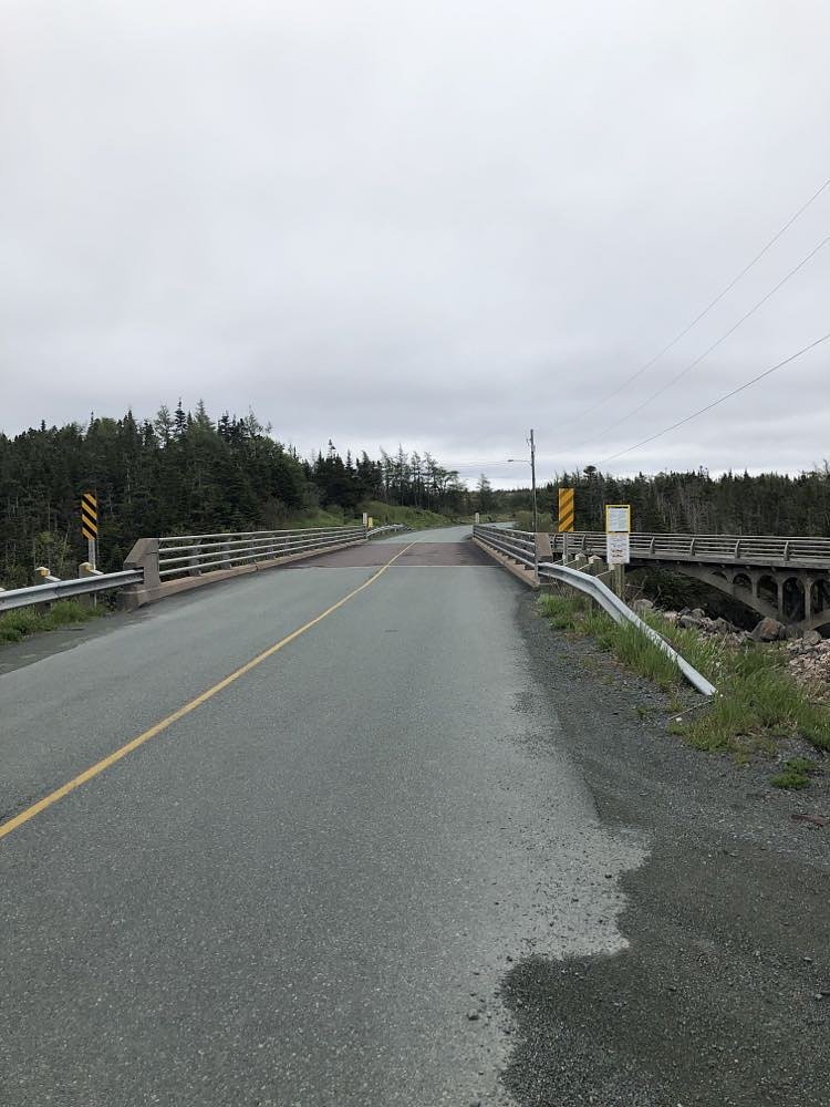

Photo Credits (2)
Difficulty
Easy
Trail Length
0.8 km
Trail Type
Out And Back
Elevation Gain
67 m
About Rocky River Fishway
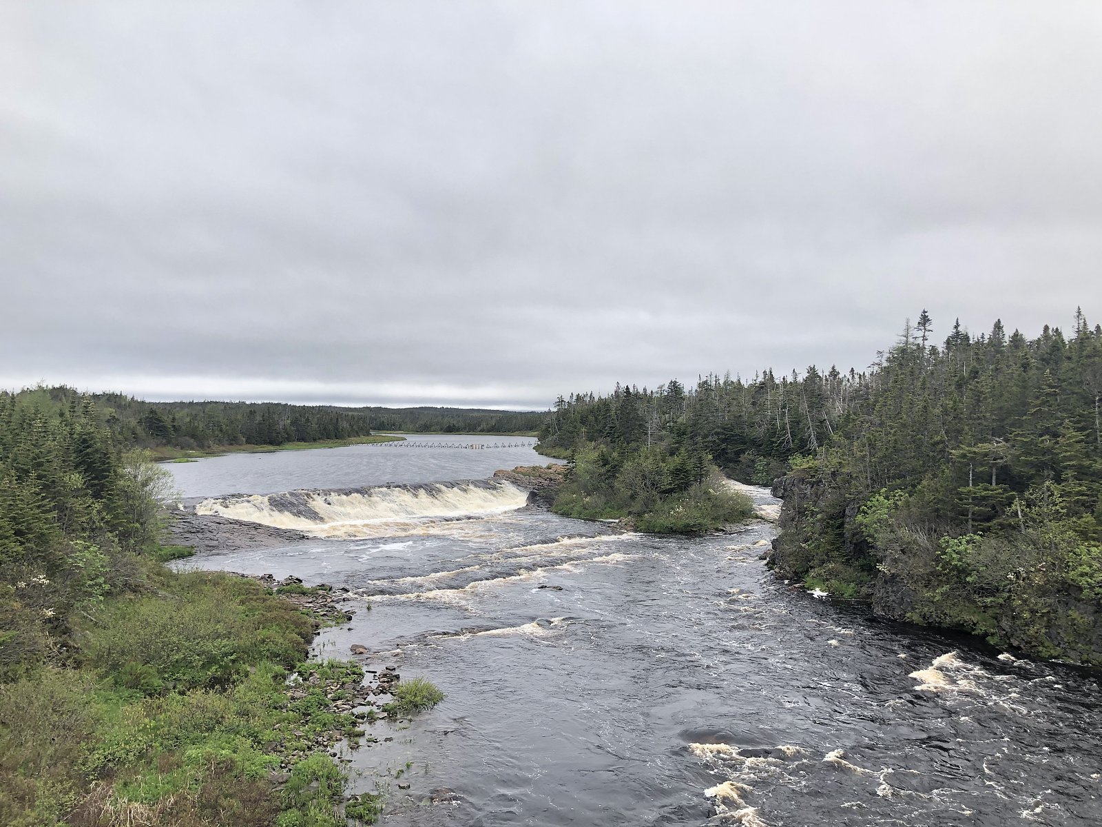
Rocky River Fishway is a small engineered fish ladder and low waterfall feature on the Rocky River on the Avalon Peninsula of Newfoundland and Labrador. It was constructed to assist migratory fish moving upstream and is located close to roadside access near Argentia/Placentia. The site is primarily of interest to people looking for fish runs, short nature stops, and local scenery rather than a large scenic waterfall.
Why This Waterfall Exists
Rocky River Fishway flows over layered sedimentary rock laid down about 539 million to 1.0 billion years ago. Over time, the stream has worn through these layers at different rates, creating the step that forms the waterfall.
Trail & Hike Details
The Approach
The easy 0.8-km out-and-back trail gains 67 metres of elevation on the way to the falls.
Trail Description
There is no developed hike to reach the fishway, it is essentially a roadside feature visible from a short walk from where you park. Visitors may need to step down a short, possibly unmaintained bank to the water's edge to get closer views of the ladder and low falls. Surfaces can be uneven, muddy, and slippery when wet.
What to Expect
Expect a modest river channel with a constructed fishway (series of stepped pools or concrete channels) and a low waterfall rather than a tall scenic cascade. Facilities are minimal or non-existent (no visitor center, restrooms, or maintained trails). Vegetation typical of Newfoundland river corridors (alder, spruce, marshy grasses) and seasonal insects in summer. During spring and early summer you may observe migratory fish activity (salmon/sea trout) and increased flows; in winter the area can be icy and covered in snow.
Accessibility
The trail is not wheelchair accessible. Uneven terrain and elevation changes require steady footing.
Frequently Asked Questions
🐶 Are Dogs Allowed at Rocky River Fishway?
❌ Dogs are not allowed
Are There Any Fees or Permits Required?
🆖 No fees required
🏊 Is There Swimming at Rocky River Fishway?
❌ Swimming is not allowed
When to Visit
Spring and early summer are often the best times to visit for observing fish runs and higher flows. Summer offers easier access for viewing and photography. Fall can provide pleasant foliage and lower visitor numbers. Winter access is possible but expect snow/ice and limited visibility of fish activity.
Seasonal Access
The best time to visit is Spring, Summer, Fall, and Winter. Check with the managing park or local authority for current conditions.
Safety Information
Watch for slippery rocks and steep or unstable banks. Currents near and below fishway structures can be unexpectedly strong. There may be no cell coverage in some spots; let someone know your plans if you travel into remote areas. Beware of insects in summer and dress appropriately for rapidly changing Newfoundland weather. If visiting in winter, expect icy conditions and limited access.
Current Water Conditions
3.1 m³/s
Current discharge — how much water is flowing
About average for this time of year
Based on 76 years of record
0.68 m
Water depth at gauge
7-Day Discharge Trend
What does this mean for your visit?
Flow is about average for this time of year.
About This Gauge
7-Day Flow Outlook
Based on the WSC gauge ROCKY RIVER NEAR COLINET (0 km away).
Today
Moderate
3.3 m³/s
6/10Tomorrow
Moderate
4.3 m³/s
6/10Tue
Moderate
3.2 m³/s
8/10Wed
Moderate
3.2 m³/s
6/10Thu
Moderate
3.6 m³/s
6/10Fri
Moderate
3.6 m³/s
6/10Sat
Moderate
3.6 m³/s
6/10Best window: Tue — moderate flow, cloudy (trip score 8/10).
Best time of year: this gauge typically runs highest from late March to late April, peaking in April.
How we calculate this
This is a transparent outlook, not a precise forecast. We take the waterfall's current flow strength (how it ranks against its historical normal for today, from the nearest WSC stream gauge), carry that ranking forward along the gauge's seasonal curve, and nudge it for forecast rain. Confidence is highest for the next day or two and falls further out. Always check official conditions and your own judgment before visiting — high flows can be dangerous.
Know when to go.
Get a free email alert when waterfalls near Argentia hit peak flow. We only send when conditions are worth the trip — no weekly newsletters, no spam.
Weather Forecast
Location & Access
Getting There
Coordinates: 47.2252, -53.5676. The fishway is on Rocky River near the Placentia/Argentia area of the Avalon Peninsula. Argentia is the closest notable community (~21.9 miles), Trepassey is farther (~32.5 miles) and St. John’s is the largest city in the region (~54.0 miles). Expect to reach the site by paved and/or well-maintained local roads; final access is typically from a roadside pullout or small informal parking area. Local signage and small bridges over the river are common landmarks. Exact driving directions and turn-by-turn approach are best checked with a recent map app or local sources before travel.
Get Directions on Google MapsParking
Limited roadside parking or a small pullout near the river/bridge. Parking is likely informal and may be muddy or uneven in wet conditions. Do not block private driveways or gate access.
Elevation
10 metres above sea level
Coordinates
47.225198° N, -53.567649° W
Visitor Tips & Gear
• Wear sturdy, waterproof footwear, banks and access points can be muddy and slippery. • Use caution when approaching the water; rocks are slick and currents can be stronger than they appear. • Bring insect repellent in summer. • There are likely no services on site, bring water and snacks if needed. • Respect private property and posted signs; stay off any fenced or posted infrastructure. • Check local sources (municipal or provincial websites) for temporary closures or maintenance work that may restrict access.
As an Amazon Associate, we earn from qualifying purchases.
For this easy 0.8 km trail, lightweight trail shoes and a water bottle are usually sufficient. Icy conditions are common in winter — traction cleats are a smart addition.

Columbia Watertight II Rain Jacket
Packs into its own pocket, seam-sealed, and keeps you dry from spray and surprise rain.

Polarized Sunglasses (Knockaround)
Cuts glare off the water so you actually see the falls — and your photos turn out better too.

Earth Pak Waterproof Dry Bag
Keeps your phone and gear dry when waterfall mist soaks everything else.

Waterproof Phone Pouch (AiRunTech)
Cheap insurance — take photos right next to the falls without killing your phone.

Kahtoola MICROspikes
Cult-favorite traction cleats that grip ice and wet rock — essential for winter waterfall hikes.

JOBY GorillaPod Starter Kit
Wraps around railings and rocks for long-exposure waterfall shots — no flat surface needed.
Where to Stay
Browse vacation cabins and private rentals nearby
Unique outdoor stays — tents, yurts, and treehouses
Rent a campervan or RV for your waterfall road trip
Some links are affiliate links. We may earn a commission at no extra cost to you.
Nearby Campground
Gushue's Pond Park
28.7 km away
Additional Information
Nearby Attractions
Placentia/Argentia historic sites (old naval and cable station history), local coastal viewpoints and small communities in Placentia Bay; Cape St. Mary's Ecological Reserve (notable seabird colony) is within general driving distance from the region, check local maps for exact distances and access.
Wildlife
Migratory fish species (salmon/sea trout/other anadromous species) may be present during runs; waterfowl and shorebirds in the river corridor; typical Newfoundland mammals in the region may include moose and small mammals. In summer expect mosquitoes and black flies in wetter areas.
Cities near Rocky River Fishway
Nearby Waterfalls

Writing about Rocky River Fishway? Embed this waterfall on your site for free.