About Rockendrop Falls
Rockendrop Falls is a relatively obscure waterfall in northwestern British Columbia, located approximately 24.2 miles (about 39 km) from Terrace at coordinates 54.4399, -129.0868. The feature appears to be in a remote, forested mountain area typical of the Kitimat Ranges and Skeena River valley tributaries. Public information on the falls is limited; access may require travel on forestry/logging roads and an off-trail approach. Visitors should treat details below as approximate and confirm local conditions before traveling.
Why This Waterfall Exists
Rockendrop Falls flows over hard banded metamorphic rock, primarily gneiss, laid down about 0 million to 4.0 billion years ago. These resistant rocks form a durable ledge that water cannot easily wear away, creating the falls where softer material downstream has already eroded.
Trail & Hike Details
Trail Description
There is no widely documented maintained trail to Rockendrop Falls. Approaches described in local trip reports for similar remote falls in the region typically involve driving on forestry roads as close as possible, then a cross-country bushwhack or short scramble through steep, forested terrain to reach the creek and falls. Footing can be unstable; route-finding skills and basic navigation (map, compass, GPS) are recommended. Expect no signage, no handrails, and no developed viewpoints.
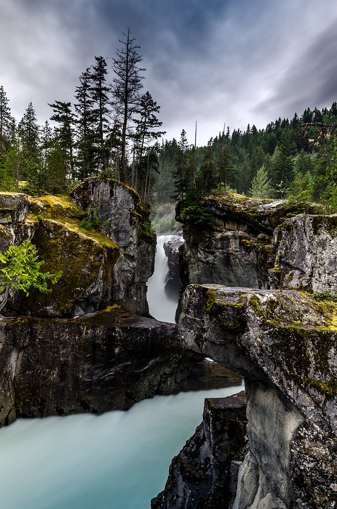
What to Expect
Expect a remote, forested setting with dense temperate rainforest/spruce-hemlock stands and typical coastal mountain understory. The waterfall may flow strongly in spring and early summer from snowmelt and after heavy rains, and at lower flows later in the season. There are likely wet, mossy rocks, steep banks, and a confined gorge or plunge pool. Services and facilities are not present. Cellular reception may be intermittent or absent.
Accessibility
Not accessible. The site appears to be in a remote setting with no developed trail or facilities; not suitable for wheelchairs, strollers, or visitors requiring paved access.
Frequently Asked Questions
🐶 Are Dogs Allowed at Rockendrop Falls?
❌ Dogs are not allowed
Are There Any Fees or Permits Required?
🆖 No fees required
🏊 Is There Swimming at Rockendrop Falls?
❌ Swimming is not allowed
When to Visit
Late spring through early fall is generally best: spring for higher flows (snowmelt), summer for easier road access and drier conditions, and fall for colors and lower water levels. Winter access may be hazardous or impossible due to snow, ice, and poor road conditions.
Seasonal Access
The best time to visit is Spring, Summer, Fall, and Winter. Check with the managing park or local authority for current conditions.
Safety Information
Hazards may include slippery and unstable rock near the falls, steep cliffs and drop-offs, strong currents and cold water in pools, changing flow conditions after rain, remote location with limited or no cell service, active logging operations on access roads, and wildlife encounters (bears). Hypothermia risk exists even in summer if immersed. Tell someone your route and expected return time. Carry an emergency communication device. If conditions are uncertain, choose a safer alternative.
Current Water Conditions
68.4 m³/s
Current discharge — how much water is flowing
About average for this time of year
Based on 63 years of record
1.21 m
Water depth at gauge
7-Day Discharge Trend
What does this mean for your visit?
Flow is about average for this time of year.
About This Gauge
This gauge is on a nearby waterway and may not reflect exact conditions at the falls.
7-Day Flow Outlook
Based on the WSC gauge EXCHAMSIKS RIVER NEAR TERRACE (17 km away).
Today
Moderate
68 m³/s
8/10Tomorrow
Moderate
74 m³/s
8/10Tue
Moderate
70 m³/s
9/10Wed
Moderate
64 m³/s
8/10Thu
Moderate
69 m³/s
8/10Fri
Moderate
76 m³/s
6/10Sat
Moderate
79 m³/s
6/10Best window: Tue — moderate flow, sunny (trip score 9/10).
Best time of year: this gauge typically runs highest from mid May to early August, peaking in June.
How we calculate this
This is a transparent outlook, not a precise forecast. We take the waterfall's current flow strength (how it ranks against its historical normal for today, from the nearest WSC stream gauge), carry that ranking forward along the gauge's seasonal curve, and nudge it for forecast rain. Confidence is highest for the next day or two and falls further out. Always check official conditions and your own judgment before visiting — high flows can be dangerous.
Know when to go.
Get a free email alert when waterfalls near Terrace hit peak flow. We only send when conditions are worth the trip — no weekly newsletters, no spam.
Weather Forecast
Location & Access
Getting There
From Terrace, BC, travel generally west/southwest on Highway 16 toward the area indicated by the coordinates (approximately 24 miles). Final access is likely via unpaved forest service or logging roads; these roads may be rough and change with active logging. A GPS unit or detailed topographic map and the coordinates above are recommended. The final approach may require hiking off-trail through steep, brushy terrain.
Get Directions on Google MapsParking
No formal parking lot is known. Expect informal pullouts or roadside parking on unpaved roads. Use care to avoid blocking gates or active logging accesses. If unsure, park at a safe, legal location and hike in.
Elevation
137 metres above sea level
Coordinates
54.439867° N, -129.086836° W
Visitor Tips & Gear
• Check current road conditions and logging activity with local authorities before traveling. • Use a reliable GPS and carry a topographic map; the coordinates are essential. • High-clearance vehicle and possibly 4x4 recommended for forestry roads; travel slowly and watch for washouts. • Carry bear spray and know how to use it; store food securely. • Wear sturdy, waterproof boots and clothing suitable for bushwhacking. Expect wet, slippery rock near the falls. • Practice Leave No Trace: pack out all trash and avoid altering the site. • Tell someone your plan and estimated return time; remote rescues are slow.
Where to Stay
Browse vacation cabins and private rentals nearby
Unique outdoor stays — tents, yurts, and treehouses
Rent a campervan or RV for your waterfall road trip
Some links are affiliate links. We may earn a commission at no extra cost to you.
Nearby Campground
Kasiks Camping
22.2 km away
Additional Information
Nearby Attractions
Nearby points of interest in the Terrace region include the Skeena River valley, local parks and trails around Terrace (for example Kleanza Creek Provincial Park and several roadside viewpoints). The town of Terrace provides services, fuel, and local information for forestry road access.
Wildlife
This part of northwestern BC supports species such as black bears (and possibly grizzly in some areas), black-tailed deer, moose, wolves, cougars, and a variety of bird life. Salmon runs occur in regional waterways seasonally. Exercise caution and store food securely.
Cities near Rockendrop Falls
Nearby Waterfalls
Writing about Rockendrop Falls? Embed this waterfall on your site for free.