Photo Credits (1)
Difficulty
Moderate
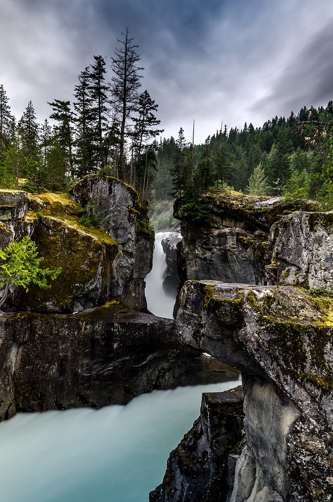
About Rockcliff Falls
Rockcliff Falls is a relatively remote waterfall located in the coastal mountains west of Terrace, British Columbia (approx. coordinates 54.4344, -129.067). The falls appear in a steep, forested drainage typical of the Skeena River watershed area. Reports and satellite imagery indicate the site is reached by secondary/unmaintained forestry roads and a short, unmarked trail or scramble to the creek/river canyon. Seasonal flow is likely highest in spring snowmelt and after heavy rain; access may be easier in summer and early fall. Specific published trail information is limited, so details on trail maintenance, exact height, and formal facilities are uncertain and should be verified locally before travel.
Why This Waterfall Exists
Rockcliff Falls flows over hard crystalline rock, primarily granite and granodiorite, laid down about 3-66 million years ago. These resistant rocks form a durable ledge that water cannot easily wear away, creating the falls where softer material downstream has already eroded.
Trail & Hike Details
Trail Description
There does not appear to be an established, maintained trail to the base of Rockcliff Falls in common guidebooks. Expect an unmarked route that may include a short hike on an old skid trail, then a steeper unmaintained scramble down to the creek/canyon. Surfaces are likely muddy and slippery, with roots and loose rock. Water crossings at small tributaries may be required depending on the approach. Route-finding skills and caution around cliff edges are recommended.
What to Expect
Dense coastal temperate rainforest with cedar/hemlock/alyssum understory, wet ground, moss and ferns. The falls likely drop into a narrow canyon or steep ravine with wet, slippery rock. Seasonal variation in water volume: peak flows in spring, lower but still scenic flows through summer and early fall. Very limited facilities (no toilets, signage, or maintained viewpoints). Cell reception may be unreliable.
Accessibility
The trail is not wheelchair accessible. Uneven terrain and elevation changes require steady footing.
Frequently Asked Questions
🐶 Are Dogs Allowed at Rockcliff Falls?
❌ Dogs are not allowed
Are There Any Fees or Permits Required?
🆖 No fees required
🏊 Is There Swimming at Rockcliff Falls?
❌ Swimming is not allowed
When to Visit
Late spring for strongest water flow (snowmelt) and lush vegetation; mid-summer to early fall for more reliable road access and drier trails. Avoid heavy rainstorms and winter months unless you are experienced with winter backcountry travel.
Seasonal Access
The best time to visit is Spring, Summer, and Fall. Winter access may be limited. Check with the managing park or local authority for current conditions.
Safety Information
Hazards include slippery and mossy rock, steep and unprotected cliffs, fast-moving water, unstable creek banks, and remote/limited cell service. Forestry roads may have loose surfaces and be used by industrial vehicles; be alert for logging trucks and obey posted closures. Weather can change quickly, expect rain and cold conditions even in summer. Carry emergency gear and do not approach edges or climb on wet rock. If uncertain about conditions, seek recent trip reports or local advice before traveling.
Current Water Conditions
68.4 m³/s
Current discharge — how much water is flowing
About average for this time of year
Based on 63 years of record
1.21 m
Water depth at gauge
7-Day Discharge Trend
What does this mean for your visit?
Flow is about average for this time of year.
About This Gauge
This gauge is on a nearby waterway and may not reflect exact conditions at the falls.
7-Day Flow Outlook
Based on the WSC gauge EXCHAMSIKS RIVER NEAR TERRACE (18 km away).
Today
Moderate
68 m³/s
8/10Tomorrow
Moderate
74 m³/s
8/10Tue
Moderate
70 m³/s
9/10Wed
Moderate
64 m³/s
8/10Thu
Moderate
69 m³/s
8/10Fri
Moderate
76 m³/s
6/10Sat
Moderate
79 m³/s
6/10Best window: Tue — moderate flow, sunny (trip score 9/10).
Best time of year: this gauge typically runs highest from mid May to early August, peaking in June.
How we calculate this
This is a transparent outlook, not a precise forecast. We take the waterfall's current flow strength (how it ranks against its historical normal for today, from the nearest WSC stream gauge), carry that ranking forward along the gauge's seasonal curve, and nudge it for forecast rain. Confidence is highest for the next day or two and falls further out. Always check official conditions and your own judgment before visiting — high flows can be dangerous.
Know when to go.
Get a free email alert when waterfalls near Terrace hit peak flow. We only send when conditions are worth the trip — no weekly newsletters, no spam.
Weather Forecast
Location & Access
Getting There
From Terrace, travel roughly 20–25 miles (road distance will vary) west/southwest toward the coastal range along Highway 16 and connecting forestry roads. The final approach is likely on unpaved logging/forestry roads; a high-clearance 4x4 vehicle is often recommended. Expect limited signage; use GPS coordinates, topographic maps, or local trip reports for the final approach. Check in with local forestry offices or town resources for current road conditions and active logging.
Get Directions on Google MapsParking
Likely roadside parking at a logging road pullout or informal parking area. Parking is probably primitive (gravel/soft shoulder). Be prepared for limited space and the possibility of encountering industrial vehicles; avoid blocking gates or road access.
Elevation
480 metres above sea level
Coordinates
54.434404° N, -129.066967° W
Visitor Tips & Gear
• Use a high-clearance, preferably 4x4 vehicle for forestry roads; check road conditions first. • Tell someone your plan and expected return time; area is remote and reception may be poor. • Wear waterproof boots with good traction; trekking poles helpful for slippery descents. • Be cautious near edges and wet rock; strong currents and undercut banks can be hazardous. • Respect private/industrial lands and active logging operations; close gates and obey signage. • Pack out all trash and follow Leave No Trace principles. • Check with local visitor centres or forestry offices for recent trip reports and road access updates before heading out.
Where to Stay
Browse vacation cabins and private rentals nearby
Unique outdoor stays — tents, yurts, and treehouses
Rent a campervan or RV for your waterfall road trip
Some links are affiliate links. We may earn a commission at no extra cost to you.
Nearby Campground
Kasiks Camping
22.8 km away
Additional Information
Nearby Attractions
The town of Terrace (services and visitor information), Skeena River vistas, and other local hiking and fishing opportunities in the Terrace area. Several waterfalls and scenic canyon sections occur throughout the Skeena watershed, check local guides for named nearby falls.
Wildlife
Coastal rainforest species: black bear, black-tailed deer, possibly cougar and wolf, bald eagles, and salmon runs in regional waterways. Practice wildlife safety (store food securely, make noise to avoid surprise encounters).
Cities near Rockcliff Falls
Nearby Waterfalls
Writing about Rockcliff Falls? Embed this waterfall on your site for free.