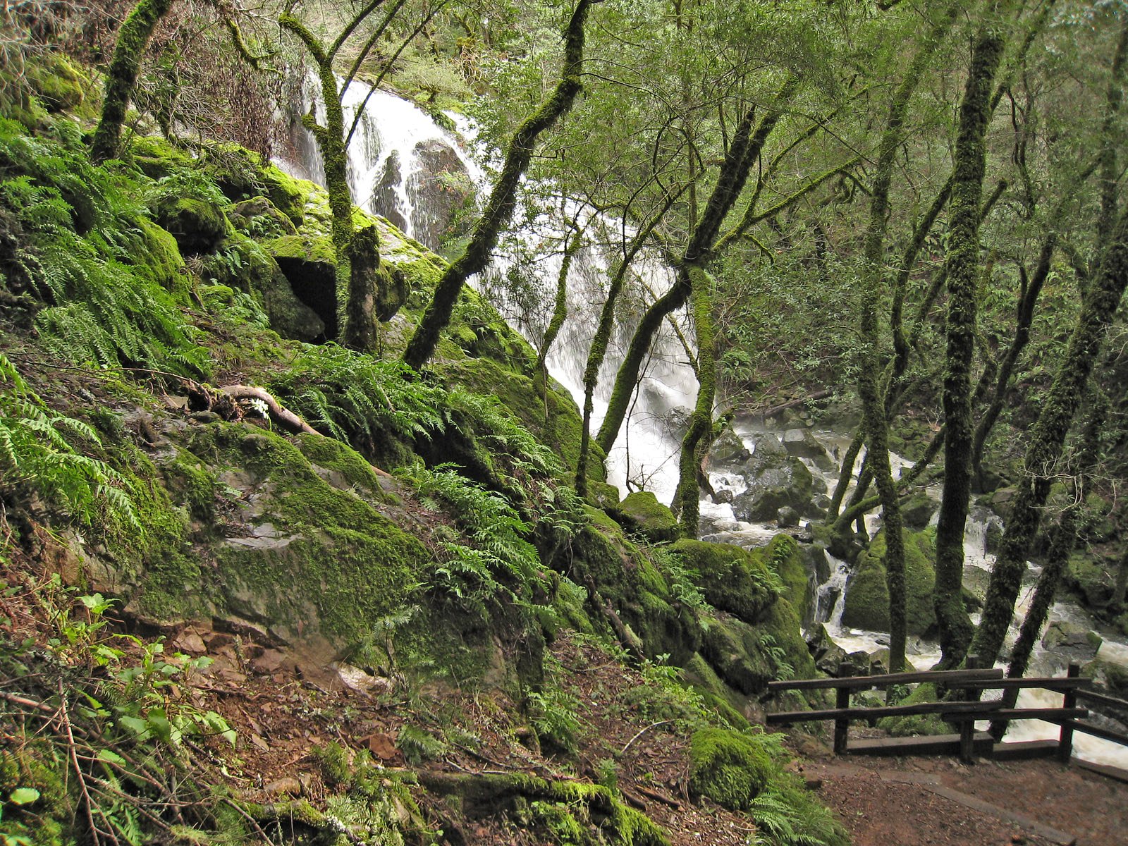
Mississagi Falls
Ontario • 1 m
By Armen Suny · Last verified Jun 2026
Photo Credits (3)
Difficulty
Drive Up
Trail Length
0.2 km
Trail Type
Out And Back
About Mississagi Falls
Mississagi Falls is a forested-river waterfall on the Mississagi River in Algoma District, Ontario, located near the communities of Thessalon and De Tour Village. The falls sit in a relatively remote, wooded setting and are most dramatic during spring runoff. Facilities are minimal or non-existent at the site; expect natural viewpoints and unpaved access. Specific infrastructure (boardwalks, formal viewing platforms) may not be present.
The Setting
Mississagi Falls sits at 186 metres within Mississagi Delta Provincial Park (Nature Reserve Class), in the foothills of Ontario. The falls drop 1 metres.
Why This Waterfall Exists
Mississagi Falls flows over hard crystalline rock, primarily tonalite, laid down over 2.5-2.8 billion years ago. These resistant rocks form a durable ledge that water cannot easily wear away, creating a 3-foot drop where softer material downstream has already eroded.
Trail & Hike Details
The Approach
No hiking required. Mississagi Falls is accessible by vehicle with a roadside viewing area.
Trail Description
Access from the parking/pullout usually involves a short, unimproved path through mixed forest to a river viewpoint. Trails, if present, are likely narrow, rocky, and may include short steep sections or a scramble to reach close river views. Expect no marked, maintained boardwalks or guardrails at informal viewpoints.
What to Expect
The falls drop a gentle 1 metres over hard crystalline rock.
Accessibility
This waterfall is viewable from a vehicle-accessible area. No hiking is required.
Frequently Asked Questions
🐶 Are Dogs Allowed at Mississagi Falls?
❌ Dogs are not allowed
Are There Any Fees or Permits Required?
🆖 No fees required
🏊 Is There Swimming at Mississagi Falls?
❌ Swimming is not allowed
When to Visit
Spring (late snowmelt/ice-out) for highest flows and dramatic waterfalls; summer for more reliable access and warmer weather (but bugs); fall for water flow combined with fall colours. Winter visits can show ice formations but access may be difficult and dangerous, only attempt with appropriate winter experience and equipment.
Seasonal Access
The best time to visit is Spring, Summer, Fall, and Winter. Check with the managing park or local authority for current conditions.
Safety Information
Hazards include slippery and unstable rocks near the river, strong currents, cold water, seasonal high flows (spring), remote location with limited cell service, variable road conditions (gravel, mud, ice), and wildlife encounters (including bears). Always stay a safe distance from the edge, avoid wet rocks, wear appropriate footwear, tell someone your itinerary, and carry basic emergency supplies. Check local advisories for road closures or safety notices before visiting.
Current Water Conditions
67.9 m³/s
Current discharge — how much water is flowing
About average for this time of year
Based on 56 years of record
10.03 m
Water depth at gauge
7-Day Discharge Trend
What does this mean for your visit?
Flow is about average for this time of year.
About This Gauge
7-Day Flow Outlook
Based on the WSC gauge MISSISSAGI RIVER AT MISSISSAGI CHUTE (0 km away).
Today
Moderate
68 m³/s
9/10Tomorrow
Moderate
73 m³/s
6/10Tue
Moderate
76 m³/s
6/10Wed
Moderate
65 m³/s
8/10Thu
Moderate
66 m³/s
6/10Fri
Moderate
68 m³/s
6/10Sat
Moderate
61 m³/s
8/10Best window: Today — moderate flow, mainly sunny (trip score 9/10).
Best time of year: this gauge typically runs highest from late March to early June, peaking in April.
How we calculate this
This is a transparent outlook, not a precise forecast. We take the waterfall's current flow strength (how it ranks against its historical normal for today, from the nearest WSC stream gauge), carry that ranking forward along the gauge's seasonal curve, and nudge it for forecast rain. Confidence is highest for the next day or two and falls further out. Always check official conditions and your own judgment before visiting — high flows can be dangerous.
Know when to go.
Get a free email alert when waterfalls near Thessalon hit peak flow. We only send when conditions are worth the trip — no weekly newsletters, no spam.
Weather Forecast
Location & Access
Getting There
Coordinates: 46.2006, -83.0279. The falls are roughly 24.5 miles (approx. 39 km) from Thessalon and about 47.8 miles (approx. 77 km) from De Tour Village. The most common approach is via Highway 17 (Trans-Canada) and local access roads; the final approach may be on secondary or gravel roads. Road and seasonal conditions can vary, check local road reports or municipal/Provincial resources before travel.
Get Directions on Google MapsParking
Parking is likely informal (small roadside pullout or unpaved parking area). Expect limited space and no staffed facilities or restrooms. Vehicles should be parked clear of the roadway; parking may be icy or muddy depending on season.
Elevation
186 metres above sea level
Coordinates
46.200565° N, -83.027885° W
Land Management
Managed by Ontario Parks
Visitor Tips & Gear
1) Check local road and weather conditions before traveling, final approach roads may be gravel or seasonally closed. 2) Wear sturdy, non-slip footwear; rocks near the river are slippery. 3) Bring insect repellent in spring/summer and traction devices in winter. 4) Expect limited or no cell service; tell someone your plans. 5) Do not climb on wet rocks near the edge and keep a safe distance from fast-flowing water. 6) If visiting in spring, be prepared for higher flows and cold water temperatures.
Where to Stay
Browse vacation cabins and private rentals nearby
Unique outdoor stays — tents, yurts, and treehouses
Rent a campervan or RV for your waterfall road trip
Some links are affiliate links. We may earn a commission at no extra cost to you.
Nearby Campground
Clear Lake Camp
22.1 km away
Additional Information
Nearby Attractions
Nearest service town: Thessalon (approx. 24.5 miles). The Lake Huron shoreline and other Algoma District parks, trails, and scenic points are regionally nearby, check local tourism resources for up-to-date listings.
Wildlife
Typical Algoma District wildlife: white-tailed deer, moose, black bear, foxes, beaver, and a variety of bird species (including waterfowl and raptors). Insect season can include blackflies and mosquitoes in spring and early summer.
Cities near Mississagi Falls
Nearby Waterfalls
Writing about Mississagi Falls? Embed this waterfall on your site for free.