Mehatl Falls
British Columbia • 6 m
By Armen Suny · Last verified Jun 2026
Difficulty
Moderate
Trail Length
7.9 km
Trail Type
Out And Back
Elevation Gain
169 m
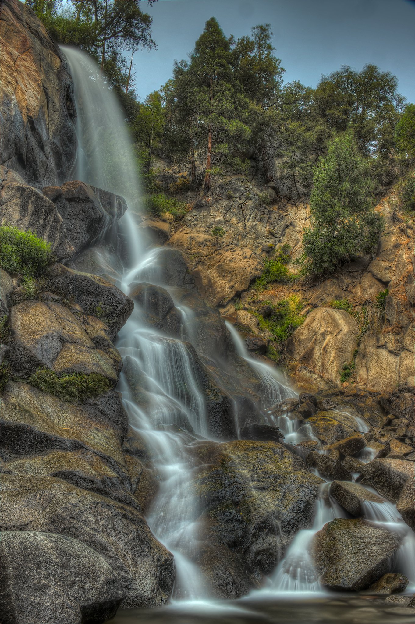
About Mehatl Falls
Mehatl Falls is a mountain waterfall in British Columbia at the coordinates provided. It appears to be a relatively remote, forested cascade on a creek or tributary in a rugged valley. Exact published descriptions and an official measured height are not widely available; the falls may be referred to locally as Mehatl Creek Falls or a similar variant.
The Setting
Mehatl Falls sits at 388 metres within MEHATL CREEK PARK, in the foothills of British Columbia. The falls drop 6 metres.
Why This Waterfall Exists
Mehatl Falls flows over hard intrusive rock laid down about 66-101 million years ago. These resistant rocks form a durable ledge that water cannot easily wear away, creating a 19-foot drop where softer material downstream has already eroded.
Trail & Hike Details
The Approach
The moderate 7.9-km out-and-back trail gains 169 metres of elevation on the way to the falls.
Trail Description
There is little authoritative trail information published for Mehatl Falls. Expect an unmaintained or lightly used route through forest and steep terrain. Trails, if present, may be faint and require route-finding, stream crossings, and short scrambles. Hikers should be prepared for variable footing, wet rocks, and limited signage. If following a forest service road, the final approach may be a bushy or steep descent to the creek.
What to Expect
The falls drop a gentle 6 metres over hard intrusive rock.
Accessibility
The trail is not wheelchair accessible. Uneven terrain and elevation changes require steady footing.
Frequently Asked Questions
🐶 Are Dogs Allowed at Mehatl Falls?
❌ Dogs are not allowed
Are There Any Fees or Permits Required?
🆖 No fees required
🏊 Is There Swimming at Mehatl Falls?
❌ Swimming is not allowed
When to Visit
Late spring and early summer for higher water flow from snowmelt; summer for easier access on roads (if dry); early fall for lower flows and fall colors. Winter can be icy and may present avalanche or unstable ice hazards, only attempt in winter with appropriate skills and equipment.
Seasonal Access
The best time to visit is Spring, Summer, Fall, and Winter. Check with the managing park or local authority for current conditions.
Safety Information
Approach waterfall areas with caution: slippery rocks, steep drop-offs, and fast-moving cold water present drowning and fall hazards. Flashy creek flows may rise quickly during rain or spring melt. Expect limited or no cell service and remote rescue response times; carry navigation and emergency equipment. If driving on forest service roads, be prepared for soft surfaces, washouts, and seasonal closures. If uncertain about conditions, choose a more conservative plan or contact local authorities.
Current Water Conditions
36.6 m³/s
Current discharge — how much water is flowing
Lower than usual for this time of year
Based on 50 years of record
1.33 m
Water depth at gauge
7-Day Discharge Trend
What does this mean for your visit?
Flow is lower than usual for this time of year.
About This Gauge
This gauge is on a nearby waterway and may not reflect exact conditions at the falls.
7-Day Flow Outlook
Based on the WSC gauge NAHATLATCH RIVER BELOW TACHEWANA CREEK (9 km away).
Today
Low
37 m³/s
6/10Tomorrow
Low
38 m³/s
5/10Tue
Low
37 m³/s
5/10Wed
Low
38 m³/s
5/10Thu
Low
38 m³/s
5/10Fri
Low
38 m³/s
5/10Sat
Low
39 m³/s
4/10Best window: Today — low flow, mainly sunny (trip score 6/10).
Best time of year: this gauge typically runs highest from early May to early August, peaking in June.
How we calculate this
This is a transparent outlook, not a precise forecast. We take the waterfall's current flow strength (how it ranks against its historical normal for today, from the nearest WSC stream gauge), carry that ranking forward along the gauge's seasonal curve, and nudge it for forecast rain. Confidence is highest for the next day or two and falls further out. Always check official conditions and your own judgment before visiting — high flows can be dangerous.
Weather Forecast
Location & Access
Getting There
The falls are in a remote, mountainous area of British Columbia (49.9287, -121.9764). Access likely requires travel on forest service or unpaved roads and then a hike on user or unmaintained trails. Expect driving on rough roads and possible need for high-clearance or 4x4 vehicles. Use a detailed topographic map or GPS and check current forest service road conditions before travel.
Get Directions on Google MapsParking
Parking is likely limited to a small roadside pullout or informal trailhead; there are likely no formal parking lots or facilities. Park clear of gates and keep access routes unobstructed. Confirm parking options locally if possible.
Elevation
388 metres above sea level
Coordinates
49.928725° N, -121.976374° W
Land Management
Managed by Government of British Columbia
Visitor Tips & Gear
• Check recent trip reports or local resources for road and trail conditions before going. • Use a topographic map and GPS; trails may be poorly marked. • Wear sturdy, waterproof footwear; expect wet and uneven terrain. • Bring insect repellent in summer and layered clothing for changing mountain weather. • Tell someone your route and expected return time; cell coverage may be unreliable. • Respect private land and posted signs if route crosses private property.
As an Amazon Associate, we earn from qualifying purchases.
With 7.9 km and 169 m of elevation gain, sturdy boots and trekking poles will help on this moderate trail. Icy conditions are common in winter — traction cleats are a smart addition.

Columbia Watertight II Rain Jacket
Packs into its own pocket, seam-sealed, and keeps you dry from spray and surprise rain.

Earth Pak Waterproof Dry Bag
Keeps your phone and gear dry when waterfall mist soaks everything else.

Waterproof Phone Pouch (AiRunTech)
Cheap insurance — take photos right next to the falls without killing your phone.

Timberland Euro Sprint Mid Waterproof
Trusted waterproof boot with premium leather and grippy rubber sole — reliable on rocky, wet trails.

TrailBuddy Trekking Poles
Lightweight aluminum, cork grips, and flip-locks that actually hold — a best-seller for good reason.

Kahtoola MICROspikes
Cult-favorite traction cleats that grip ice and wet rock — essential for winter waterfall hikes.
Where to Stay
Browse vacation cabins and private rentals nearby
Unique outdoor stays — tents, yurts, and treehouses
Rent a campervan or RV for your waterfall road trip
Some links are affiliate links. We may earn a commission at no extra cost to you.
Nearby Campground
Squakum Creek Campsite
16.9 km away
Additional Information
Nearby Attractions
Specific nearby attractions are not well-documented for this precise location. The area is generally characteristic of BC interior mountain scenery with rivers, lakes, and forested backcountry; nearby towns and official parks may exist within driving distance, confirm with regional maps and local visitor resources.
Wildlife
Typical interior-BC wildlife may be present: black bears, possibly grizzly bears in some regions, cougars, deer, small mammals, and abundant mosquitoes/blackflies in summer. Practice bear-aware behaviour and store food properly.
Nearby Waterfalls
Writing about Mehatl Falls? Embed this waterfall on your site for free.