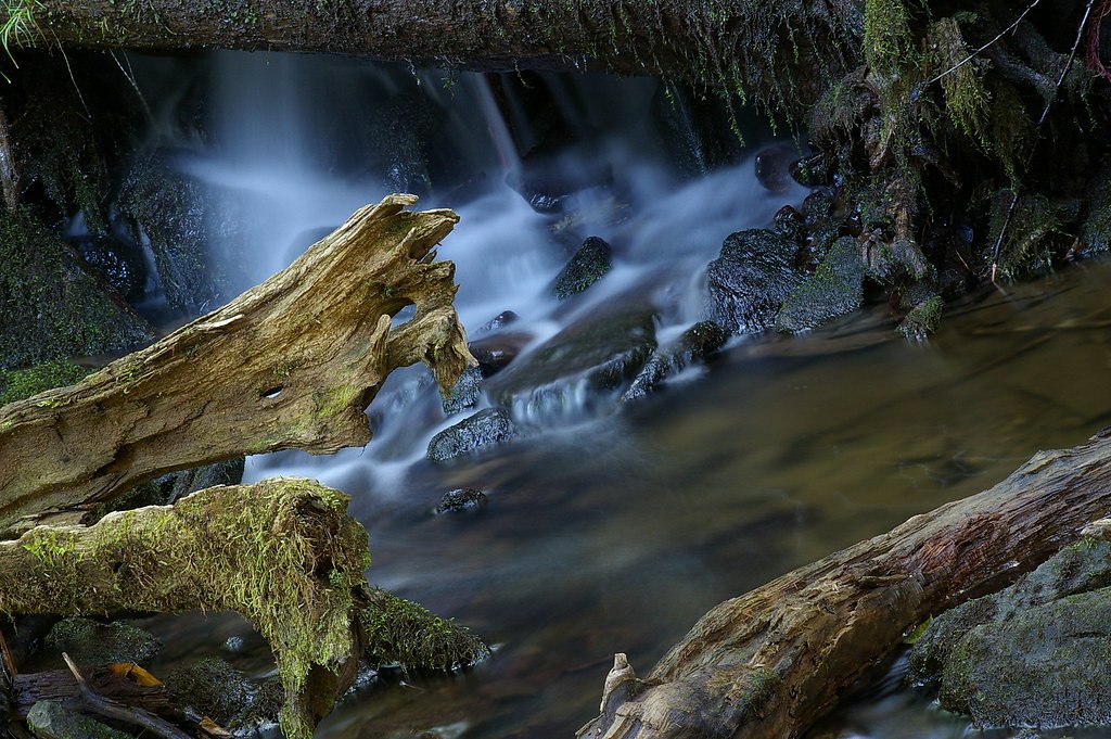
Lower Dunbar Falls
New Brunswick • 1 m
By Armen Suny · Last verified Jun 2026
Difficulty
Easy
Trail Length
1.4 km
Trail Type
Out And Back
Elevation Gain
40 m
About Lower Dunbar Falls
Lower Dunbar Falls is a small, forested waterfall feature near Fredericton, New Brunswick (coordinates 46.1418, -66.6192). It appears as a stream cascade through mixed woodland and may form stepped drops and small pools. Specific published measurements and official signage are limited; the falls are best described as a local natural feature visited by people familiar with backroads and local trails.
The Setting
Lower Dunbar Falls sits at 42 metres in the coastal lowlands of New Brunswick. The falls drop 1 metres.
Why This Waterfall Exists
Lower Dunbar Falls flows over layered sedimentary rock laid down about 299-359 million years ago. Over time, the stream has worn through these layers at different rates, creating a 3-foot drop that forms the waterfall.
Trail & Hike Details
The Approach
The easy 1.4-km out-and-back trail gains 40 metres of elevation on the way to the falls.
Trail Description
Approach to Lower Dunbar Falls is likely via an unpaved spur or short footpath through mixed forested terrain. Trails (if present) may be narrow, uneven, and muddy in wet seasons with roots and rocks underfoot. There may be a short scramble to reach the water's edge. Expect limited wayfinding: bring a GPS, map, or download offline directions beforehand. Leave no trace and avoid making new social trails.
What to Expect
The falls drop a gentle 1 metres over layered sedimentary rock.
Accessibility
The trail is short and relatively flat, but the surface may be uneven. Contact the managing agency for accessibility details.
Frequently Asked Questions
🐶 Are Dogs Allowed at Lower Dunbar Falls?
❌ Dogs are not allowed
Are There Any Fees or Permits Required?
🆖 No fees required
🏊 Is There Swimming at Lower Dunbar Falls?
❌ Swimming is not allowed
When to Visit
Spring (snowmelt and spring rains) typically yields the strongest flows. Late spring to early summer provides good water flow and warmer weather. Fall offers colorful foliage but cooler water and shorter daylight. Winter access may be limited or hazardous due to ice and snow; the falls may be partially frozen and approach routes slippery.
Seasonal Access
The best time to visit is Spring, Summer, and Fall. Winter access may be limited. Check with the managing park or local authority for current conditions.
Safety Information
Hazards can include slippery rocks and banks, unstable or unconsolidated edges, rapidly changing stream flows after rain, cold water, limited cell service, and seasonal insects. Use caution near water, avoid climbing on wet rock, and supervise children closely. If visiting in winter, expect ice hazards and deep snow in places.
Current Water Conditions
7.9 m³/s
Current discharge — how much water is flowing
Lower than usual for this time of year
Based on 63 years of record
17.82 m
Water depth at gauge
7-Day Discharge Trend
What does this mean for your visit?
Flow is lower than usual for this time of year.
About This Gauge
7-Day Flow Outlook
Based on the WSC gauge NASHWAAK RIVER AT DURHAM BRIDGE (2 km away).
Today
Moderate
8.6 m³/s
5/10Tomorrow
Moderate
7.6 m³/s
6/10Tue
Low
7.0 m³/s
5/10Wed
Moderate
6.9 m³/s
5/10Thu
Moderate
8.7 m³/s
5/10Fri
Moderate
8.1 m³/s
6/10Sat
Moderate
7.9 m³/s
5/10Best window: Tomorrow — moderate flow, cloudy (trip score 6/10).
Best time of year: this gauge typically runs highest from late March to early June, peaking in April.
How we calculate this
This is a transparent outlook, not a precise forecast. We take the waterfall's current flow strength (how it ranks against its historical normal for today, from the nearest WSC stream gauge), carry that ranking forward along the gauge's seasonal curve, and nudge it for forecast rain. Confidence is highest for the next day or two and falls further out. Always check official conditions and your own judgment before visiting — high flows can be dangerous.
Know when to go.
Get a free email alert when waterfalls near Fredericton hit peak flow. We only send when conditions are worth the trip — no weekly newsletters, no spam.
Weather Forecast
Location & Access
Getting There
The falls lie roughly 13 miles from Fredericton and about 62 miles from Vanceboro (as noted). Access is typically by car on local roads; final approach may be along a short forest or logging road and/or an unmarked trailhead. Expect minimal or no signage. Visitors should plan a route using a GPS coordinate or local maps and allow extra time for slow gravel roads.
Get Directions on Google MapsParking
Parking is likely informal, a roadside pullout or small gravel area. Do not assume a formal lot, vault toilet, or maintained facilities. Park well off the roadway and avoid blocking gates or private driveways.
Elevation
42 metres above sea level
Coordinates
46.141790° N, -66.619211° W
Visitor Tips & Gear
• Wear sturdy, waterproof footwear with good traction, rocks near the falls will be slippery. • Check recent local reports or contact local land managers if possible before visiting. • Avoid visiting alone in remote areas and tell someone your plans. • Bring insect repellent (ticks and black flies can be common in season). • Do not rely on trails being well-marked; bring GPS coordinates and a physical map. • Pack out all trash; no facilities or trash service expected. • Be cautious after heavy rain, water levels and currents can rise quickly.
As an Amazon Associate, we earn from qualifying purchases.
For this easy 1.4 km trail, lightweight trail shoes and a water bottle are usually sufficient. Sun exposure on the trail makes good sun protection a must in summer.

Columbia Watertight II Rain Jacket
Packs into its own pocket, seam-sealed, and keeps you dry from spray and surprise rain.

Earth Pak Waterproof Dry Bag
Keeps your phone and gear dry when waterfall mist soaks everything else.

Waterproof Phone Pouch (AiRunTech)
Cheap insurance — take photos right next to the falls without killing your phone.

Polarized Sunglasses (Knockaround)
Cuts glare off the water so you actually see the falls — and your photos turn out better too.

Osprey Daylite Daypack
Light, organized, and just the right size for a day hike — fits water, snacks, and layers.

OR Sombriolet Sun Hat
UPF 50+ sun protection with vents so your head doesn't cook on exposed trail sections.
Where to Stay
Browse vacation cabins and private rentals nearby
Unique outdoor stays — tents, yurts, and treehouses
Rent a campervan or RV for your waterfall road trip
Some links are affiliate links. We may earn a commission at no extra cost to you.
Nearby Campground
River's Edge Campground
1 km away
Additional Information
Nearby Attractions
Fredericton (approx. 13 miles) offers city parks, riverfront trails, and cultural sites. Exact proximity to other named attractions depends on your route; local forest roads and river corridors may have additional natural features and smaller falls.
Wildlife
Expect typical New Brunswick woodland wildlife: white-tailed deer, beaver, small mammals, various bird species, and the potential for black bears. Ticks and biting insects (black flies, mosquitoes) are common in warm months.
Cities near Lower Dunbar Falls
Nearby Waterfalls
Writing about Lower Dunbar Falls? Embed this waterfall on your site for free.