Difficulty
Easy
Trail Type
Out And Back
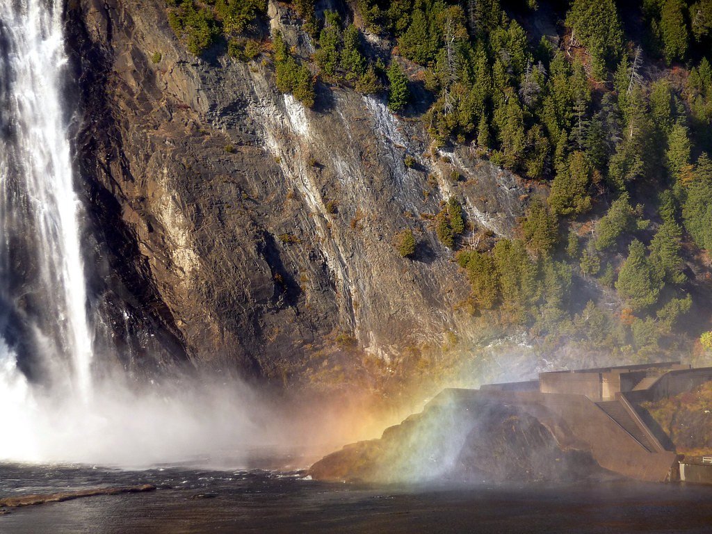
About Le Slalom
Le Slalom is a cascade-style waterfall located roughly 21 miles (≈34 km) from Québec City. Coordinates provided are 47.05, -71.4605. The site appears to be a relatively small to moderate cascade set in a forested, river-valley setting. Flow and appearance likely vary seasonally, higher in spring runoff and lower in late summer. Specific published measurements and official descriptions are limited or not confirmed, so some local trail details may vary.
Why This Waterfall Exists
Le Slalom flows over hard banded metamorphic rock, primarily gneiss, laid down over 1.4-1.6 billion years ago. These resistant rocks form a durable ledge that water cannot easily wear away, creating the falls where softer material downstream has already eroded.
Nearby Falls Worth Visiting
Chute à Pageau (2 m) lies 5.5 kilometres to the northeast.
Trail & Hike Details
Trail Description
Approach is likely along a short forested trail or via an informal path from a roadside pullout. Trails may be narrow, muddy after rain or snowmelt, and could include roots and rocks. Expect limited signage and few built facilities (railings, boardwalks). Route-finding may be required near the stream channel and the falls.
What to Expect
A wooded setting with a cascade/slide-style waterfall. Water flow varies with season, highest in spring runoff, lower in late summer and frozen or partially frozen in winter. The immediate area may have slippery rocks, steep banks, and wet trails. Crowds are likely light compared with major tourist waterfalls, but this depends on local access and signage.
Accessibility
The trail is short and relatively flat, but the surface may be uneven. Contact the managing agency for accessibility details.
Frequently Asked Questions
🐶 Are Dogs Allowed at Le Slalom?
❌ Dogs are not allowed
Are There Any Fees or Permits Required?
🆖 No fees required
🏊 Is There Swimming at Le Slalom?
❌ Swimming is not allowed
When to Visit
Spring (snowmelt) for highest flows and dramatic water; fall for foliage color; summer for easier trail conditions. Winter can offer icy/frozen waterfall scenery but may be slippery and require winter hiking gear.
Seasonal Access
The best time to visit is Spring, Summer, Fall, and Winter. Check with the managing park or local authority for current conditions.
Safety Information
Hazards can include slippery rocks and trails, steep or unstable banks near the falls, fast water and cold currents, falling ice in winter, and limited cell reception. Do not climb on wet rocks or attempt to swim near drops. Tell someone your route and expected return time. If conditions are icy or trails are obscured by snow, use appropriate winter traction and consider avoiding the site.
7-Day Flow Outlook
Based on the WSC gauge HURONS (RIVIERE DES) A STONEHAM (8 km away).
Best time of year: this gauge typically runs highest from early April to early June, peaking in May.
How we calculate this
This is a transparent outlook, not a precise forecast. We take the waterfall's current flow strength (how it ranks against its historical normal for today, from the nearest WSC stream gauge), carry that ranking forward along the gauge's seasonal curve, and nudge it for forecast rain. Confidence is highest for the next day or two and falls further out. Always check official conditions and your own judgment before visiting — high flows can be dangerous.
Know when to go.
Get a free email alert when waterfalls near Québec hit peak flow. We only send when conditions are worth the trip — no weekly newsletters, no spam.
Weather Forecast
Location & Access
Getting There
Access typically requires driving on local secondary roads from Québec City. Exact approach roads and turnoffs are not confirmed here; expect a short forest road or paved country road followed by a trail or roadside access. Use a detailed local map or GPS coordinates (47.05, -71.4605) and check current local signage before setting out.
Get Directions on Google MapsParking
Parking may be informal: a small unmarked lot or roadside pullout is likely. Park only where allowed and avoid blocking gates, driveways or private property. If no official lot exists, plan for limited parking and use caution when parking on road shoulders.
Hours
Elevation
197 metres above sea level
Coordinates
47.049984° N, -71.460484° W
Visitor Tips & Gear
• Wear sturdy, grippy footwear, streamside rocks and trails can be slippery. • Expect minimal facilities: no toilets, no formal viewing platforms in many small falls. • Use the provided coordinates and an up-to-date map or GPS; cell reception can be spotty. • Respect private property and posted signs; some waterfalls are on or adjacent to private land. • Leave no trace: pack out all trash and avoid disturbing vegetation or streambanks. • If unsure about directions, consult local trail resources or recent visitor reports before going.
Where to Stay
Browse vacation cabins and private rentals nearby
Unique outdoor stays — tents, yurts, and treehouses
Rent a campervan or RV for your waterfall road trip
Some links are affiliate links. We may earn a commission at no extra cost to you.
Nearby Campground
Camping Talbot
9.8 km away
Additional Information
Nearby Attractions
Québec City is approximately 21 miles away (user-provided reference). The broader region contains provincial parks, rivers, and forested recreation areas, check local tourism or park listings for named nearby attractions.
Wildlife
Typical regionally likely species include white-tailed deer, beaver, small mammals and various bird species. Black bears may be present in some forested parts of Quebec; exercise normal wilderness precautions. Avoid approaching or feeding wildlife.
Cities near Le Slalom
Nearby Waterfalls
Writing about Le Slalom? Embed this waterfall on your site for free.