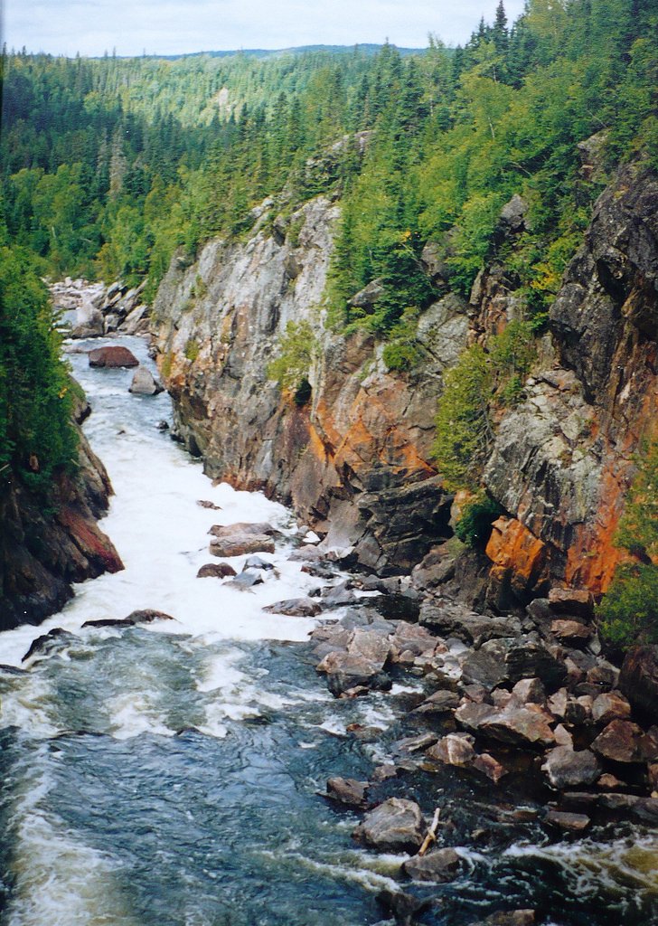
Hook Falls
Ontario • Pukaskwa National Park • 2 m
By Armen Suny · Last verified Jun 2026

Photo Credits (4)
Difficulty
Hard
Trail Length
20.8 km
Trail Type
Out And Back
Elevation Gain
493 m
About Hook Falls
Hook Falls is a small cascade-style waterfall located on a tributary near Marathon, Ontario (approx. 15.4 miles from Marathon; coordinates 48.5542, -86.2286). The falls are in a heavily forested region along the Lake Superior shorelands. Flow is typically highest in spring runoff and after heavy rains; in winter it may form ice features but access and safety are more challenging. Detailed official descriptions and measurements for this specific fall are limited, so some location and access details may vary.
The Setting
Hook Falls sits at 222 metres within Pukaskwa National Park, in the foothills of Ontario. The falls drop 2 metres.
Why This Waterfall Exists
Hook Falls flows over hard intrusive rock, primarily granodiorite and tonalite, laid down over 2.5-3.2 billion years ago. These resistant rocks form a durable ledge that water cannot easily wear away, creating a 6-foot drop where softer material downstream has already eroded.
Nearby Falls Worth Visiting
Chigamiwinigum Falls (50 m) lies 0.6 kilometres to the northwest.
Trail & Hike Details
The Approach
The hard 20.8-km out-and-back trail gains 493 metres of elevation on the way to the falls.
Trail Description
Trail information for Hook Falls is limited. Approaches are likely a short unmarked path through boreal forest and over uneven terrain; expect roots, rocks, and potentially steep or slippery sections near the stream and falls. Trails in this region are often unmaintained and not waymarked, carry a map/GPS and be prepared for rough footing.
What to Expect
The falls drop a gentle 2 metres over hard intrusive rock.
Accessibility
The trail involves steep, uneven terrain with significant elevation change and is not accessible to mobility devices.
Frequently Asked Questions
🐶 Are Dogs Allowed at Hook Falls?
❌ Dogs are not allowed
Are There Any Fees or Permits Required?
🆖 No fees required
🏊 Is There Swimming at Hook Falls?
❌ Swimming is not allowed
When to Visit
Spring (high water) and early summer (full flows, fewer ice hazards) are often best for seeing the falls at higher volume. Fall offers good foliage color but lower flows. Winter can produce dramatic ice formations but presents higher risk from snow, ice, and limited access.
Seasonal Access
The best time to visit is Spring, Summer, Fall, and Winter. Check with Pukaskwa National Park for current conditions.
Safety Information
Hazards may include slippery rocks, steep drop-offs, fast-flowing or cold water, unstable banks, and remote conditions with limited cell service. In winter expect ice, deep snow, and avalanche or cornice risks on exposed slopes in some areas. Travel with a companion when possible, tell someone your plans, carry navigation aids, and be prepared for changing weather. If unsure about route conditions, consult local authorities or recent visitor reports.
Current Water Conditions
Based on a Water Survey of Canada gauge 25 km away
10.8 m³/s
Current discharge — how much water is flowing
Much lower than usual for this time of year
Based on 56 years of record
1.84 m
Water depth at gauge
7-Day Discharge Trend
What does this mean for your visit?
Flow is well below normal for this time of year, so the waterfall may be a trickle.
About This Gauge
This gauge is on a regional waterway. Conditions at the falls may differ, especially after local rain.
7-Day Flow Outlook
Based on the WSC gauge PIC RIVER NEAR MARATHON (25 km away).
Today
Barely Flowing
11 m³/s
4/10Tomorrow
Barely Flowing
11 m³/s
3/10Tue
Low
11 m³/s
4/10Wed
Barely Flowing
10 m³/s
4/10Thu
Barely Flowing
10 m³/s
3/10Fri
Barely Flowing
10.0 m³/s
4/10Sat
Barely Flowing
9.3 m³/s
4/10Best window: Today — barely flowing flow, fog (trip score 4/10).
Best time of year: this gauge typically runs highest from mid April to late June, peaking in May.
How we calculate this
This is a transparent outlook, not a precise forecast. We take the waterfall's current flow strength (how it ranks against its historical normal for today, from the nearest WSC stream gauge), carry that ranking forward along the gauge's seasonal curve, and nudge it for forecast rain. Confidence is highest for the next day or two and falls further out. Always check official conditions and your own judgment before visiting — high flows can be dangerous.
Know when to go.
Get a free email alert when waterfalls near Marathon hit peak flow. We only send when conditions are worth the trip — no weekly newsletters, no spam.
Weather Forecast
Location & Access
Getting There
The falls are reached from the Marathon area by local secondary roads or forestry/logging roads; exact turnoffs and road conditions may change seasonally. Visitors should plan for unpaved roads and limited signage. A high-clearance vehicle may be helpful in wet conditions. Exact access route is not confirmed here, consult local maps, park/municipal resources, or recent visitor trip reports before going.
Get Directions on Google MapsParking
There may be an informal pullout or small parking area near the trailhead. Expect no formal parking lot, no services, and possibly only room for a few vehicles. Parking details are not definitively documented; exercise caution when parking on road shoulders.
Elevation
222 metres above sea level
Coordinates
48.554192° N, -86.228557° W
Land Management
Managed by Parks Canada Agency
Visitor Tips & Gear
• Check recent trip reports or contact local visitor information in Marathon for current access and road conditions. • Wear sturdy, water-resistant footwear with good traction, rocks are slippery. • Bring insect repellent in spring/summer; ticks and mosquitoes can be active. • No guaranteed facilities or garbage removal, pack out what you pack in. • Keep a safe distance from edges and unstable rock; do not climb near the top of the falls. • If driving on forestry roads, watch for soft spots and be prepared for narrow single-lane sections.
As an Amazon Associate, we earn from qualifying purchases.
This challenging 20.8 km trail gains 493 m in elevation — come prepared with proper hiking boots and trekking poles. Icy conditions are common in winter — traction cleats are a smart addition.

Columbia Watertight II Rain Jacket
Packs into its own pocket, seam-sealed, and keeps you dry from spray and surprise rain.

Sawyer Squeeze Water Filter
The backcountry standard — filters 99.9% of bacteria and weighs just 3 oz.

Polarized Sunglasses (Knockaround)
Cuts glare off the water so you actually see the falls — and your photos turn out better too.

Earth Pak Waterproof Dry Bag
Keeps your phone and gear dry when waterfall mist soaks everything else.

Waterproof Phone Pouch (AiRunTech)
Cheap insurance — take photos right next to the falls without killing your phone.

Timberland Euro Sprint Mid Waterproof
Trusted waterproof boot with premium leather and grippy rubber sole — reliable on rocky, wet trails.
Where to Stay
Browse vacation cabins and private rentals nearby
Unique outdoor stays — tents, yurts, and treehouses
Rent a campervan or RV for your waterfall road trip
Some links are affiliate links. We may earn a commission at no extra cost to you.
Nearby Campground
Hook Falls 1
0.6 km away
Additional Information
Nearby Attractions
Lake Superior shoreline and coastal viewpoints near Marathon; regional parks and conservation areas are in the broader region (for example, Neys Provincial Park and Pukaskwa National Park are notable nearby provincial/national park destinations though distances vary). Check local visitor centres for up-to-date nearby attraction suggestions and distances.
Wildlife
Typical north shore wildlife: black bears, moose, white-tailed deer, beaver, and a variety of birds. Insects including mosquitoes and ticks are seasonally common. Practice standard wildlife safety and store food securely.
Cities near Hook Falls
Nearby Waterfalls
Writing about Hook Falls? Embed this waterfall on your site for free.