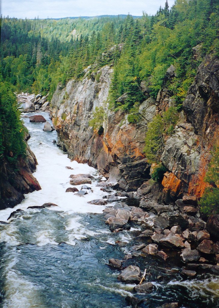
Chigamiwinigum Falls
Ontario • Pukaskwa National Park • 50 m
By Armen Suny · Last verified Jun 2026

Photo Credits (2)
Difficulty
Moderate
Trail Length
17.7 km
Trail Type
Out And Back
Elevation Gain
250 m
About Chigamiwinigum Falls
Chigamiwinigum Falls is a relatively remote waterfall site in northeastern Ontario, located about 15 miles (approx.) from the town of Marathon. Coordinates: 48.5594, -86.2332. The waterfall sits in a forested Lake Superior region and is likely accessed via secondary/logging roads and a short unmaintained approach. Specific published details (official park listing, measured height, or maintained trail) are limited, so visitors should plan for an unmarked or lightly used route and variable flow depending on season.
The Setting
Chigamiwinigum Falls sits at 228 metres within Pukaskwa National Park, in the foothills of Ontario. At 50 metres, it is among the taller waterfalls in Ontario.
Why This Waterfall Exists
Chigamiwinigum Falls flows over hard intrusive rock, primarily granodiorite and tonalite, laid down over 2.5-3.2 billion years ago. These resistant rocks form a durable ledge that water cannot easily wear away, creating a 164-foot drop where softer material downstream has already eroded.
Trail & Hike Details
The Approach
The moderate 17.7-km out-and-back trail gains 250 metres of elevation on the way to the falls.
Trail Description
There is no widely published maintained trail to Chigamiwinigum Falls. Expect an approach that uses logging/forestry roads followed by an unmaintained footpath or bushwhack through mixed boreal forest and possibly across uneven ground, stream crossings, and soft soils. The route may be faintly marked by previous visitors but is not an official groomed trail. Trail length, elevation gain, and exact route are not well documented; plan conservatively and allow extra time.
What to Expect
The falls plunge 50 metres over hard intrusive rock.
Accessibility
The trail is not wheelchair accessible. Uneven terrain and elevation changes require steady footing.
Frequently Asked Questions
🐶 Are Dogs Allowed at Chigamiwinigum Falls?
❌ Dogs are not allowed
Are There Any Fees or Permits Required?
🆖 No fees required
🏊 Is There Swimming at Chigamiwinigum Falls?
❌ Swimming is not allowed
When to Visit
Late spring (high water flow) and early fall (color) are often most scenic. Summer offers easier footing and warmer weather but lower flows may reduce spectacle. Winter visits are possible for experienced parties with winter gear but expect icy, hazardous conditions and limited access.
Seasonal Access
The best time to visit is Spring, Summer, Fall, and Winter. Check with Pukaskwa National Park for current conditions.
Safety Information
Hazards include slippery wet rocks, steep or unstable banks, unmarked terrain, stream crossings, limited or no cell service, sudden changes in weather, and wildlife encounters. In winter expect ice, hard-to-detect hazards, and deep snow. Do not approach cliff edges or stand on wet rocks near flows. If you are inexperienced in remote travel, go with an experienced party or guide. Check local forestry operation notices and road conditions before travel.
Current Water Conditions
Based on a Water Survey of Canada gauge 24.3 km away
10.8 m³/s
Current discharge — how much water is flowing
Much lower than usual for this time of year
Based on 56 years of record
1.84 m
Water depth at gauge
7-Day Discharge Trend
What does this mean for your visit?
Flow is well below normal for this time of year, so the waterfall may be a trickle.
About This Gauge
This gauge is on a regional waterway. Conditions at the falls may differ, especially after local rain.
7-Day Flow Outlook
Based on the WSC gauge PIC RIVER NEAR MARATHON (24 km away).
Today
Barely Flowing
11 m³/s
4/10Tomorrow
Barely Flowing
11 m³/s
3/10Tue
Low
11 m³/s
4/10Wed
Barely Flowing
10 m³/s
4/10Thu
Barely Flowing
10 m³/s
3/10Fri
Barely Flowing
10.0 m³/s
4/10Sat
Barely Flowing
9.3 m³/s
4/10Best window: Today — barely flowing flow, fog (trip score 4/10).
Best time of year: this gauge typically runs highest from mid April to late June, peaking in May.
How we calculate this
This is a transparent outlook, not a precise forecast. We take the waterfall's current flow strength (how it ranks against its historical normal for today, from the nearest WSC stream gauge), carry that ranking forward along the gauge's seasonal curve, and nudge it for forecast rain. Confidence is highest for the next day or two and falls further out. Always check official conditions and your own judgment before visiting — high flows can be dangerous.
Know when to go.
Get a free email alert when waterfalls near Marathon hit peak flow. We only send when conditions are worth the trip — no weekly newsletters, no spam.
Weather Forecast
Location & Access
Getting There
From Marathon, Ontario (approx. 15 miles), travel by vehicle toward the coordinates 48.5594, -86.2332. Access is likely via secondary roads or logging roads off the Trans-Canada Highway (Highway 17) and may require a high-clearance or 4x4 vehicle. The final approach is probably on foot over unmarked or minimally maintained terrain; expect a bushwhack or faint footpath. Visitors should carry GPS with the above coordinates, check local road/forest conditions, and contact local authorities or outdoor groups for current access notes before attempting.
Get Directions on Google MapsParking
No formal parking lot is known. Parking is likely roadside or at a gated logging-road pullout; space may be limited and parking may be on private or Crown land subject to local rules. Do not block gates or access roads. If in doubt, park in Marathon and obtain local guidance.
Elevation
228 metres above sea level
Coordinates
48.559376° N, -86.233222° W
Land Management
Managed by Parks Canada Agency
Visitor Tips & Gear
1) Tell someone your route and expected return time; cell service may be unreliable. 2) Use a GPS and the provided coordinates (48.5594, -86.2332). 3) Wear sturdy waterproof boots and bring layers; conditions can be wet and changeable. 4) Carry insect repellent in spring/summer and tick checks after. 5) Respect private property and forestry operations, do not enter active work sites. 6) Pack out what you pack in and avoid making new social trails. 7) If unfamiliar with remote navigation, consider going with a local guide or experienced group.
As an Amazon Associate, we earn from qualifying purchases.
With 17.7 km and 250 m of elevation gain, sturdy boots and trekking poles will help on this moderate trail. Icy conditions are common in winter — traction cleats are a smart addition.

Columbia Watertight II Rain Jacket
Packs into its own pocket, seam-sealed, and keeps you dry from spray and surprise rain.

Polarized Sunglasses (Knockaround)
Cuts glare off the water so you actually see the falls — and your photos turn out better too.

Earth Pak Waterproof Dry Bag
Keeps your phone and gear dry when waterfall mist soaks everything else.

Waterproof Phone Pouch (AiRunTech)
Cheap insurance — take photos right next to the falls without killing your phone.

Timberland Euro Sprint Mid Waterproof
Trusted waterproof boot with premium leather and grippy rubber sole — reliable on rocky, wet trails.

TrailBuddy Trekking Poles
Lightweight aluminum, cork grips, and flip-locks that actually hold — a best-seller for good reason.
Where to Stay
Browse vacation cabins and private rentals nearby
Unique outdoor stays — tents, yurts, and treehouses
Rent a campervan or RV for your waterfall road trip
Some links are affiliate links. We may earn a commission at no extra cost to you.
Nearby Campground
Chigamiwinigum Falls 1
0.4 km away
Additional Information
Nearby Attractions
Town of Marathon (services), Lake Superior shoreline, and other regional outdoor recreation opportunities. Specific nearby provincial parks or named attractions should be checked on local maps as distances may be significant.
Wildlife
Typical northern Ontario species: black bear, moose, white-tailed deer, wolves/coyotes, beaver, various waterfowl, mosquitoes and ticks in warm months. Take standard wildlife precautions (store food securely, maintain distance, carry bear deterrent if recommended locally).
Cities near Chigamiwinigum Falls
Nearby Waterfalls
Writing about Chigamiwinigum Falls? Embed this waterfall on your site for free.