Difficulty
Easy
Trail Length
3.1 km
Trail Type
Out And Back
Elevation Gain
49 m
About Homesite Creek Falls
Homesite Creek Falls is a small, forested cascade on Homesite Creek in coastal British Columbia. The falls are in a temperate coastal forest setting and are likely most impressive during spring snowmelt and after heavy rains. Published, detailed official descriptions are limited; access appears to be via local forest/secondary roads and an unmaintained footpath or short scramble rather than a developed park trail. Visitors should expect a relatively natural, undeveloped site rather than formal viewing infrastructure.
The Setting
Homesite Creek Falls sits at 93 metres within Old Growth Management Areas (Mapped Legal), in the coastal lowlands of British Columbia. The falls drop 6 metres.
Why This Waterfall Exists
Homesite Creek Falls flows over hard intrusive rock laid down about 101-145 million years ago. These resistant rocks form a durable ledge that water cannot easily wear away, creating a 19-foot drop where softer material downstream has already eroded.
Trail & Hike Details
The Approach
The easy 3.1-km out-and-back trail gains 49 metres of elevation on the way to the falls.
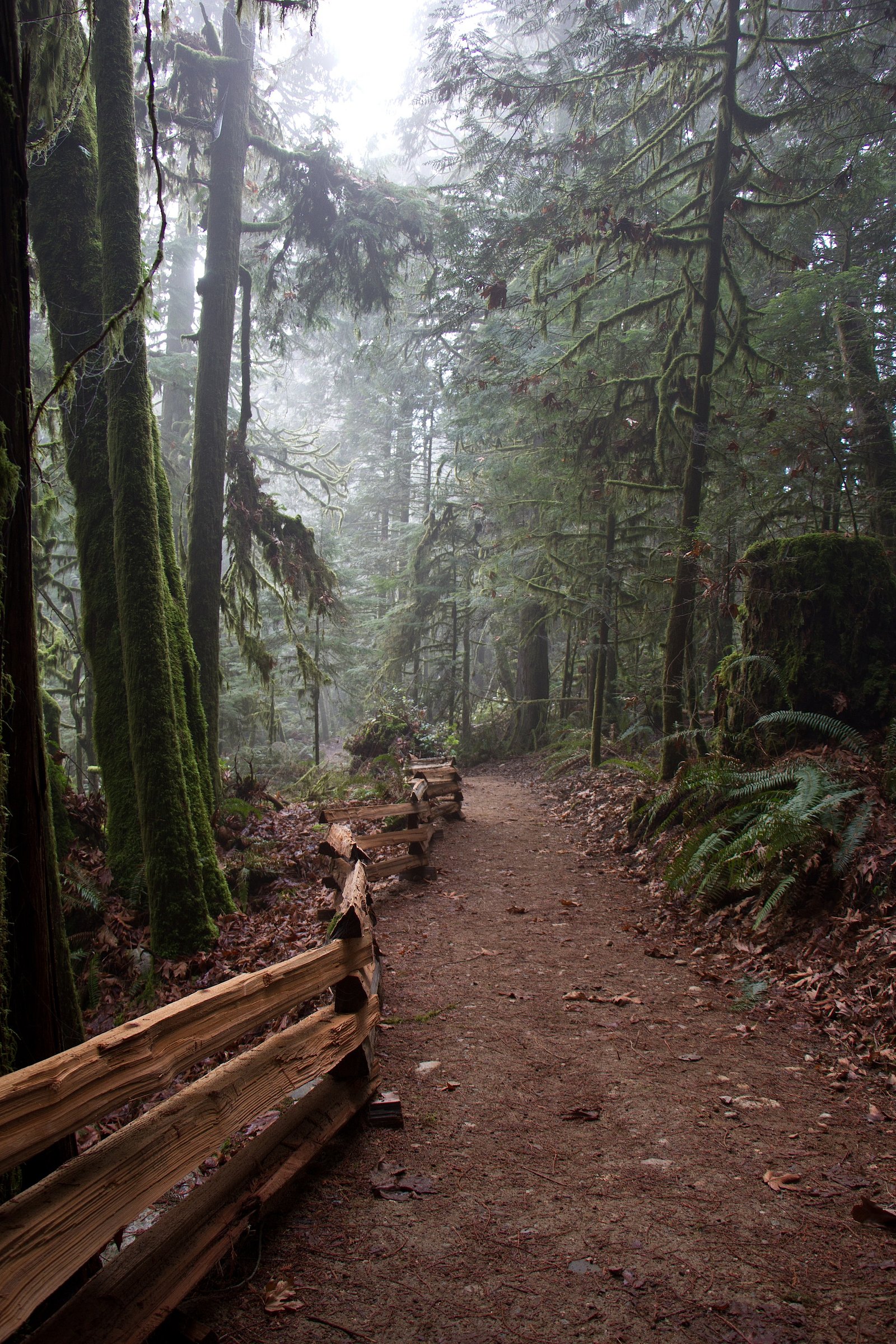
Trail Description
Approach is likely via an unmaintained footpath leaving the roadside; expect rooty, muddy trail sections and short, possibly steep scrambles to reach viewpoints. Trails may be short (less than a few miles round-trip) but uneven underfoot. There is probably no formal viewing platform or handrails. Because official trail data is sparse, plan for waypoint navigation (GPS coordinates), and allow extra time for route-finding.
What to Expect
The falls drop a gentle 6 metres over hard intrusive rock.
Accessibility
The trail is not wheelchair accessible. Uneven terrain and elevation changes require steady footing.
Frequently Asked Questions
🐶 Are Dogs Allowed at Homesite Creek Falls?
❌ Dogs are not allowed
Are There Any Fees or Permits Required?
🆖 No fees required
🏊 Is There Swimming at Homesite Creek Falls?
❌ Swimming is not allowed
When to Visit
Late winter through spring for the strongest flows; summer for easier access and drier trails but reduced flow. After heavy rain events the creek will be fuller but trails can be muddy and slippery.
Seasonal Access
The best time to visit is Spring, Summer, and Fall. Winter access may be limited. Check with the managing park or local authority for current conditions.
Safety Information
Hazards include slippery rocks, steep banks, fast-flowing water after rains, unstable or eroding streambanks, limited cell reception, and potential seasonal logging activity. Do not attempt to climb wet rock faces or stand close to unprotected cliffs. Check local conditions and land access before visiting. If access uses logging roads, be aware of heavy equipment and closed gates.
7-Day Flow Outlook
Based on the WSC gauge ROBERTS CREEK AT ROBERTS CREEK (25 km away).
Today
Barely Flowing
0.1 m³/s
4/10Tomorrow
Barely Flowing
0.1 m³/s
4/10Tue
Barely Flowing
0.1 m³/s
4/10Wed
Barely Flowing
0.1 m³/s
4/10Thu
Barely Flowing
0.1 m³/s
4/10Fri
Barely Flowing
0.1 m³/s
4/10Sat
Barely Flowing
0.1 m³/s
4/10Best window: Today — barely flowing flow, cloudy (trip score 4/10).
Best time of year: this gauge typically runs highest from early January to late January, peaking in November.
How we calculate this
This is a transparent outlook, not a precise forecast. We take the waterfall's current flow strength (how it ranks against its historical normal for today, from the nearest WSC stream gauge), carry that ranking forward along the gauge's seasonal curve, and nudge it for forecast rain. Confidence is highest for the next day or two and falls further out. Always check official conditions and your own judgment before visiting — high flows can be dangerous.
Know when to go.
Get a free email alert when waterfalls near Nanaimo hit peak flow. We only send when conditions are worth the trip — no weekly newsletters, no spam.
Weather Forecast
Location & Access
Getting There
Coordinates: 49.5314, -123.9352. The falls are on Homesite Creek in coastal British Columbia, reachable from local secondary/forest roads off the Sunshine Coast/nearby regional routes. Access likely requires driving to a pullout or small parking area and then following an unmarked or lightly marked footpath; expect short off-trail sections and possibly a stream crossing. Because local logging roads, private land, or seasonal gates may affect routes, check local maps and recent trip reports before you go.
Get Directions on Google MapsParking
Small roadside pullout or informal parking near a forest/secondary road is likely. Parking may be limited and may require a short walk; do not block gates or private driveways. If logging roads are used, follow posted signs and respect seasonal closures.
Elevation
93 metres above sea level
Coordinates
49.531417° N, -123.935180° W
Land Management
Managed by Government of British Columbia
Visitor Tips & Gear
• Wear sturdy, waterproof footwear with good traction; expect mud and slippery rocks. • Use a GPS device or map; trail may be unmarked. • Stay off unstable banks and out of the creek except at designated crossings; rocks are slippery and falls can be harmful. • Check for logging activity, locked gates, or private property before using logging roads. Respect any posted signs. • Pack out all trash and follow Leave No Trace principles. • Tell someone your plans if heading into remote/unmarked areas.
As an Amazon Associate, we earn from qualifying purchases.
This easy 3.1 km hike is straightforward — comfortable trail shoes and plenty of water should do. Sun exposure on the trail makes good sun protection a must in summer.

Columbia Watertight II Rain Jacket
Packs into its own pocket, seam-sealed, and keeps you dry from spray and surprise rain.

Earth Pak Waterproof Dry Bag
Keeps your phone and gear dry when waterfall mist soaks everything else.

Waterproof Phone Pouch (AiRunTech)
Cheap insurance — take photos right next to the falls without killing your phone.

Polarized Sunglasses (Knockaround)
Cuts glare off the water so you actually see the falls — and your photos turn out better too.

Osprey Daylite Daypack
Light, organized, and just the right size for a day hike — fits water, snacks, and layers.

OR Sombriolet Sun Hat
UPF 50+ sun protection with vents so your head doesn't cook on exposed trail sections.
Where to Stay
Browse vacation cabins and private rentals nearby
Unique outdoor stays — tents, yurts, and treehouses
Rent a campervan or RV for your waterfall road trip
Some links are affiliate links. We may earn a commission at no extra cost to you.
Nearby Campground
Homesite Creek Campground
1.8 km away
Additional Information
Nearby Attractions
Regional towns and services (Nanaimo, Powell River, Vancouver via ferry connections), coastal forest recreation areas, viewpoints and local hiking trails on the Sunshine Coast and Vancouver Island. Specific nearby named attractions should be confirmed with local tourism or park resources.
Wildlife
Typical coastal BC species may be present: black bears, cougars (rare), deer, small mammals, and abundant birdlife. Be bear-aware and keep food secured.
Cities near Homesite Creek Falls
Nearby Waterfalls
Writing about Homesite Creek Falls? Embed this waterfall on your site for free.