Holmden Creek Falls
By Armen Suny · Last verified Jun 2026
Difficulty
Easy
Trail Length
0.2 km
Trail Type
Out And Back
About Holmden Creek Falls
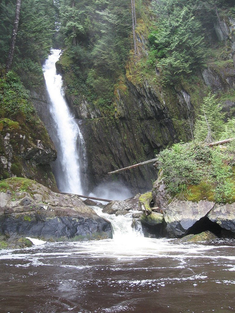
Holmden Creek Falls is a small forested waterfall on Holmden Creek in the Lower Mainland of British Columbia (coordinates: 49.3765, -122.8918). The site is relatively close to the Canada–US border and lies within the broader Greater Vancouver / Delta region (approximately 16.4 miles from central Vancouver, ~25.5 miles from Blaine WA, and ~26.0 miles from Point Roberts). The waterfall appears to be a modest cascade or series of drops in a wooded creek corridor; depending on seasonal rainfall it may be anything from a pronounced cascade in spring/fall to a lower-flow feature in late summer. Precise published height and official trail designation are not readily available and may be limited to informal/local access.
The Setting
Holmden Creek Falls sits at 105 metres within Thwaytes Landing Regional Park, in the coastal lowlands of British Columbia.
Why This Waterfall Exists
Holmden Creek Falls flows over Gambier Group, a hard volcanic rock layer deposited about 66-145 million years ago. These resistant rocks form a durable ledge that water cannot easily wear away, creating the falls where softer material downstream has already eroded.
Nearby Falls Worth Visiting
Russell Falls (25 m) lies 2.6 kilometres to the northwest. Also nearby: Sunshine Falls (12 m, 3.9 km).
Trail & Hike Details
Trail Description
There is no widely published, maintained trail description for Holmden Creek Falls in major trail databases. Expect any path to be informal: a short, possibly steep or muddy scramble from roadside or a nearby trail down to the creek. Vegetation can be dense and the approach may cross uneven, rooty terrain. If a nearby park or municipal trail provides access, follow official signage and stay on designated routes.
What to Expect
A small, wooded creek cascade in a riparian setting. Expect mossy rocks, fallen logs, and a narrow creek channel. Flow is highly seasonal, strongest in spring and after heavy rains, reduced in late summer. Viewpoints may be limited to the creek bank and may require a short scramble to get closer. Little to no developed visitor infrastructure (railings, viewing platforms) is expected.
Accessibility
The trail is short and relatively flat, but the surface may be uneven. Contact the managing agency for accessibility details.
Frequently Asked Questions
🐶 Are Dogs Allowed at Holmden Creek Falls?
❌ Dogs are not allowed
Are There Any Fees or Permits Required?
🆖 No fees required
🏊 Is There Swimming at Holmden Creek Falls?
❌ Swimming is not allowed
When to Visit
Late winter through spring and into fall after rain events typically offer the best water flow and more impressive visuals. Late summer may have much lower flow. Visit mid-week or early in the morning to avoid any informal parking pressure or local traffic.
Seasonal Access
The best time to visit is Spring, Summer, and Fall. Winter access may be limited. Check with the managing park or local authority for current conditions.
Safety Information
Hazards may include slippery rocks, steep or unstable banks, high water/strong currents after heavy rain, fallen trees, poor footing, and limited or no safety infrastructure. There may be private property boundaries, do not trespass. Cell service may be unreliable in pockets. Use caution, avoid risky rock-hopping near edges, and do not swim near drops. If uncertain of conditions, do not attempt a close approach.
Current Water Conditions
0.2 m³/s
Current discharge — how much water is flowing
Much lower than usual for this time of year
Based on 25 years of record
1.31 m
Water depth at gauge
7-Day Discharge Trend
What does this mean for your visit?
Flow is well below normal for this time of year, so the waterfall may be a trickle.
About This Gauge
This gauge is on a nearby waterway and may not reflect exact conditions at the falls.
7-Day Flow Outlook
Based on the WSC gauge CEDAR CREEK ABOVE THE MOUTH (8 km away).
Today
Barely Flowing
0.2 m³/s
4/10Tomorrow
Barely Flowing
0.1 m³/s
4/10Tue
Barely Flowing
0.1 m³/s
4/10Wed
Barely Flowing
0.2 m³/s
4/10Thu
Barely Flowing
0.2 m³/s
4/10Fri
Barely Flowing
0.1 m³/s
4/10Sat
Barely Flowing
0.2 m³/s
3/10Best window: Today — barely flowing flow, cloudy (trip score 4/10).
Best time of year: this gauge typically runs highest from late October to late November, peaking in October.
How we calculate this
This is a transparent outlook, not a precise forecast. We take the waterfall's current flow strength (how it ranks against its historical normal for today, from the nearest WSC stream gauge), carry that ranking forward along the gauge's seasonal curve, and nudge it for forecast rain. Confidence is highest for the next day or two and falls further out. Always check official conditions and your own judgment before visiting — high flows can be dangerous.
Know when to go.
Get a free email alert when waterfalls near Vancouver hit peak flow. We only send when conditions are worth the trip — no weekly newsletters, no spam.
Weather Forecast
Location & Access
Getting There
The waterfall is near the coordinates 49.3765, -122.8918 in the Lower Mainland. Public access details are not well documented in major guide resources; approach likely requires travel on local roads and then a short walk through forested or riparian terrain. Access may be across municipal, regional park, or private lands, confirm route and permissions with local authorities or land managers before visiting.
Get Directions on Google MapsParking
No formal parking lot is confirmed for this feature. Where visited historically, parking has been roadside or in informal pullouts; park only where legal and safe. If accessing from a nearby park or trailhead, use the official parking there.
Elevation
105 metres above sea level
Coordinates
49.376513° N, -122.891825° W
Land Management
Managed by Metro Vancouver Regional District
Visitor Tips & Gear
• Verify access and ownership before visiting; some approaches may cross private land. • Wear sturdy, waterproof footwear with good traction; banks and rocks can be slippery. • Bring a map or GPS with the provided coordinates and a charged phone; local cell service may be intermittent. • Avoid approaching the top of the falls or standing on wet rocks above the drop. Keep children close and supervised. • Respect posted signs and do not park illegally or block driveways. • Leave no trace: pack out all trash and avoid disturbing vegetation and stream banks.
Where to Stay
Browse vacation cabins and private rentals nearby
Unique outdoor stays — tents, yurts, and treehouses
Rent a campervan or RV for your waterfall road trip
Some links are affiliate links. We may earn a commission at no extra cost to you.
Nearby Campground
North Twin Campground
3.1 km away
Nearby Hot Springs
Hot springs near Vancouver, British Columbia
Dorr Fumarole Field
Dorr Fumarole Field reaches 194 degrees at 8,168 feet elevation on Mount Baker's active volcanic slopes, producing superheated ...

Sherman Crater Fumaroles
Sherman Crater Fumaroles register 266 degrees Fahrenheit at 9,463 feet elevation within the active volcanic crater atop Mount B...
Looking for a soak after your hike? Explore more hot springs near Vancouver, British Columbia on SoakingSprings.
Explore British Columbia springsAdditional Information
Nearby Attractions
The waterfall sits in the general coastal/municipal area near the southern edge of the Metro Vancouver region and the Canada–US border. Nearby communities and coastal parks in the broader area may include regional beaches, shoreline parks, and local trails; confirm specific nearby attractions using local municipal or regional park maps.
Wildlife
Typical riparian and suburban Lower Mainland species may be present: waterfowl and shorebirds, songbirds, small mammals (squirrels, raccoons), and occasional larger mammals in nearby undeveloped areas. Mosquitoes and ticks can be present in warmer months. Always maintain distance from wildlife.
Cities near Holmden Creek Falls
Nearby Waterfalls
Writing about Holmden Creek Falls? Embed this waterfall on your site for free.