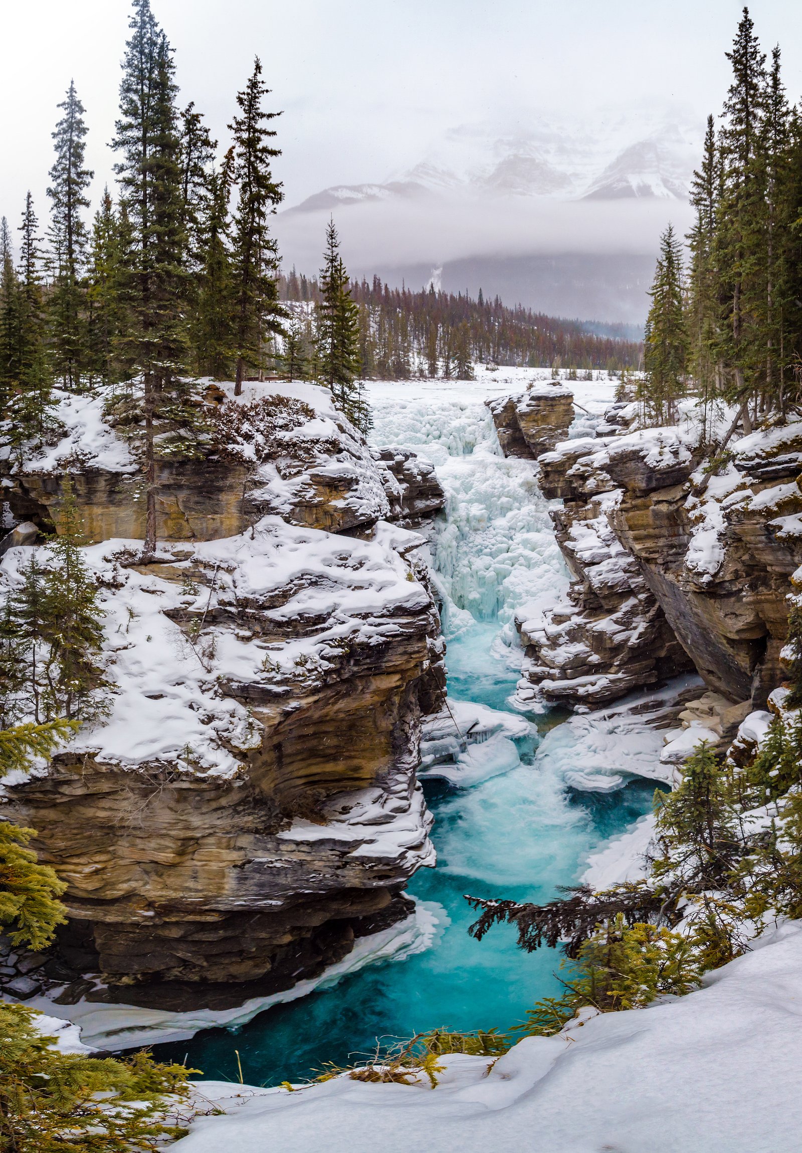
Geraldine Falls
Alberta • Jasper National Park
By Armen Suny · Last verified Jun 2026
Difficulty
Hard
Trail Length
8.4 km
Trail Type
Out And Back
Elevation Gain
407 m
About Geraldine Falls
Geraldine Falls is a remote cascade located roughly 19.9 miles (about 32 km) south of Jasper, Alberta (coordinates provided). The falls appear as a series of drops/cascades along a tributary creek in a forested, mountainous setting. Exact official details (official trail name, measured height) are not confirmed here; visitors should treat descriptions as approximate and verify with Parks Canada or local trail guides before travel.
The Setting
Geraldine Falls sits at 1,802 metres within Jasper National Park, in the high mountains of Alberta.
Why This Waterfall Exists
Geraldine Falls flows over layered sedimentary rock laid down about 485 million to 1.0 billion years ago. Over time, the stream has worn through these layers at different rates, creating the step that forms the waterfall.
Nearby Falls Worth Visiting
Athabasca Falls (23 m) lies 8.0 kilometres to the northeast.
Trail & Hike Details
The Approach
The hard 8.4-km out-and-back trail gains 407 metres of elevation on the way to the falls.
Trail Description
Publicly available, clearly marked trail information for Geraldine Falls is limited. Expect a forested approach with uneven terrain, potential creek crossings, and variable footing (roots, rocks, mud). Trails in this area may be informal or user-created rather than developed maintained routes. Use a map/GPS and recent trip reports; cell coverage may be limited.
What to Expect
A scenic, relatively undeveloped waterfall setting with cascading water over bedrock steps. Water flow likely highest in spring (snowmelt) and after heavy rain, lower in late summer. Surrounding terrain is typical Rocky Mountain mixed conifer forest with alder and willow near riparian zones. Facilities (restrooms, picnic tables, railings) are unlikely. Wildlife such as bears, moose, and elk may be present in the area.
Accessibility
The trail involves steep, uneven terrain with significant elevation change and is not accessible to mobility devices.
Frequently Asked Questions
🐶 Are Dogs Allowed at Geraldine Falls?
❌ Dogs are not allowed
Are There Any Fees or Permits Required?
🆖 No fees required
🏊 Is There Swimming at Geraldine Falls?
❌ Swimming is not allowed
When to Visit
Late spring and early summer for highest flows and vibrant runoff; summer for easier access and warmer weather; early fall for lower crowds and fall colors. Winter visits are possible but can be hazardous (ice, deep snow, closed/unplowed roads) and are recommended only for experienced winter backcountry travelers.
Seasonal Access
The best time to visit is Spring, Summer, and Fall. Access roads and trails may close during winter due to snow. Check with Jasper National Park for current conditions.
Safety Information
Hazards include remote location, variable trail conditions, slippery rock near the falls, cold water and strong currents, sudden weather changes, and wildlife encounters (including bears). Roads and trails may be seasonally closed or impassable. Carry navigation aids, inform someone of your plans, and check current conditions with Parks Canada or local authorities before traveling.
Current Water Conditions
Based on a Water Survey of Canada gauge 31.4 km away
31.0 m³/s
Current discharge — how much water is flowing
About average for this time of year
Based on 59 years of record
1.32 m
Water depth at gauge
7-Day Discharge Trend
What does this mean for your visit?
Flow is about average for this time of year.
About This Gauge
This gauge is on a regional waterway. Conditions at the falls may differ, especially after local rain.
7-Day Flow Outlook
Based on the WSC gauge MIETTE RIVER NEAR JASPER (31 km away).
Today
Strong
33 m³/s
8/10Tomorrow
Strong
33 m³/s
8/10Tue
Strong
32 m³/s
8/10Wed
Moderate
28 m³/s
8/10Thu
Strong
28 m³/s
8/10Fri
Strong
27 m³/s
8/10Sat
Strong
27 m³/s
8/10Best window: Today — strong flow, rain showers (trip score 8/10).
Best time of year: this gauge typically runs highest from mid May to mid August, peaking in June.
How we calculate this
This is a transparent outlook, not a precise forecast. We take the waterfall's current flow strength (how it ranks against its historical normal for today, from the nearest WSC stream gauge), carry that ranking forward along the gauge's seasonal curve, and nudge it for forecast rain. Confidence is highest for the next day or two and falls further out. Always check official conditions and your own judgment before visiting — high flows can be dangerous.
Know when to go.
Get a free email alert when waterfalls near Jasper hit peak flow. We only send when conditions are worth the trip — no weekly newsletters, no spam.
Weather Forecast
Location & Access
Getting There
Located at approximately 52.6007, -117.9387, the falls are reached by driving from Jasper toward the coordinate area and then using local forest or resource roads and foot trails. Access may require travel on unpaved roads and a short hike; condition of roads can vary seasonally. Check local Parks Canada or Alberta forest district information and recent trip reports before going.
Get Directions on Google MapsParking
There may not be a formal parking lot at the falls; parking is likely limited to roadside pullouts or informal parking near trailheads. Expect minimal infrastructure and possible parking restrictions if inside park boundaries. Confirm parking options with local authorities.
Elevation
1,802 metres above sea level
Coordinates
52.600716° N, -117.938705° W
Land Management
Managed by Parks Canada Agency
Visitor Tips & Gear
• Verify exact location and access with Parks Canada or local forest service before you go. • Use a detailed topographic map or GPS with the provided coordinates; cell service may be unreliable. • Wear sturdy, waterproof footwear for wet and uneven trails; expect slippery rocks near the falls. • Carry bear spray and know how to use it if hiking in Jasper-area backcountry. • Do not rely on informal parking, avoid blocking gates or private access roads. • Leave no trace: pack out all trash and avoid disturbing vegetation or stream banks.
This trail sits at 5,912 ft above sea level
Elevated TrailUV radiation is roughly 24% stronger at this elevation than at sea level, and the dry air accelerates dehydration. Extra sun protection and fluids go a long way.
As an Amazon Associate, we earn from qualifying purchases.

Coppertone Sport SPF 50 Sunscreen
UV intensity jumps ~4% per 1,000 ft — at this elevation you can burn in half the time.

Sun Bum SPF 30 Lip Balm (3-Pack)
Lips have almost no natural UV protection and burn fast in thin, dry mountain air.

Liquid I.V. Electrolyte Packets
You lose moisture ~2x faster at elevation — electrolytes help you absorb water efficiently.

ROCKNIGHT Polarized UV400 Sunglasses
High-altitude glare off rock and water is intense — UV400 lenses block 99%+ of UVA/UVB.
As an Amazon Associate, we earn from qualifying purchases.
This challenging 8.4 km trail gains 407 m in elevation — come prepared with proper hiking boots and trekking poles. Sun exposure on the trail makes good sun protection a must in summer.

Sawyer Squeeze Water Filter
The backcountry standard — filters 99.9% of bacteria and weighs just 3 oz.

Columbia Watertight II Rain Jacket
Packs into its own pocket, seam-sealed, and keeps you dry from spray and surprise rain.

Earth Pak Waterproof Dry Bag
Keeps your phone and gear dry when waterfall mist soaks everything else.

Waterproof Phone Pouch (AiRunTech)
Cheap insurance — take photos right next to the falls without killing your phone.

Timberland Euro Sprint Mid Waterproof
Trusted waterproof boot with premium leather and grippy rubber sole — reliable on rocky, wet trails.

TrailBuddy Trekking Poles
Lightweight aluminum, cork grips, and flip-locks that actually hold — a best-seller for good reason.
Where to Stay
Browse vacation cabins and private rentals nearby
Unique outdoor stays — tents, yurts, and treehouses
Rent a campervan or RV for your waterfall road trip
Some links are affiliate links. We may earn a commission at no extra cost to you.
Nearby Campground
South Geraldine Lake
1.5 km away
Additional Information
Nearby Attractions
General Jasper National Park attractions in the broader region include scenic viewpoints, lakes, and waterfalls (e.g., Athabasca Falls, Maligne Lake), verify exact distances and directions. Local hiking and sightseeing opportunities vary across the park.
Wildlife
Typical Rocky Mountain species may be present: black bear and grizzly bears, moose, elk, deer, mountain goats, and small mammals. Practice wildlife safety, store food securely, and maintain distance from wildlife.
Cities near Geraldine Falls
Nearby Waterfalls
Writing about Geraldine Falls? Embed this waterfall on your site for free.