Gardner Creek Falls
By Armen Suny · Last verified Jun 2026
Difficulty
Drive Up
Trail Length
0.2 km
Trail Type
Out And Back
About Gardner Creek Falls
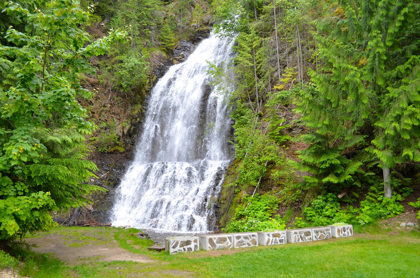
Gardner Creek Falls is a relatively remote creek waterfall located in southeastern British Columbia, approximately 54 miles from Revelstoke (approximate coordinates: 50.2871, -117.7308). Reports and mapping references indicate it is on a tributary of Gardner Creek and sits within a forested, mountainous landscape. Flow and visibility are highly seasonal, spring snowmelt typically produces the highest flows, while late summer and early fall can see reduced water. Specific published information on the waterfall is limited; details below reflect commonly reported conditions for similar roadside/forest-road falls in this region and should be treated as approximate.
Why This Waterfall Exists
Gardner Creek Falls flows over hard intrusive rock laid down about 162-175 million years ago. These resistant rocks form a durable ledge that water cannot easily wear away, creating the falls where softer material downstream has already eroded.
Trail & Hike Details
The Approach
No hiking required. Gardner Creek Falls is accessible by vehicle with a roadside viewing area.
Trail Description
Public information on an established trail to Gardner Creek Falls is scarce. Access commonly involves driving a forest or logging road to a nearby pullout and following an unmarked social path or creek bed. Trails may be indistinct, steep in sections, and potentially involve short scrambles over rocky stream banks. Expect wet, muddy, and rooty sections in spring and after rain. Because routefinding details are limited, plan for route-finding on rough terrain and limited trail maintenance.
What to Expect
A small to medium forested waterfall on a creek in a mountainous, forested setting. Expect dense coniferous forest, moss-covered rocks, and seasonal flow variability. High flows in spring and early summer from snowmelt; lower flow or isolated cascades by late summer. Limited or no formal viewing platforms, railings, or maintained trails. Remote setting with limited cell coverage is likely.
Accessibility
This waterfall is viewable from a vehicle-accessible area. No hiking is required.
Frequently Asked Questions
🐶 Are Dogs Allowed at Gardner Creek Falls?
❌ Dogs are not allowed
Are There Any Fees or Permits Required?
🆖 No fees required
🏊 Is There Swimming at Gardner Creek Falls?
❌ Swimming is not allowed
When to Visit
Spring (snowmelt) and early summer for highest flows and fuller cascades; fall for foliage colors. Winter access may be difficult or unsafe due to snow, icy roads, and avalanche risk on nearby slopes, only attempt if you have winter backcountry experience and appropriate equipment.
Seasonal Access
The best time to visit is Spring, Summer, and Fall. Winter access may be limited. Check with the managing park or local authority for current conditions.
Safety Information
Hazards may include slippery and unstable rocks near the creek and falls, steep or eroding banks, rapidly changing water levels during spring runoff or after heavy rain, poor or no cell coverage, and remote location which can delay emergency response. Forest roads may be rough, require high-clearance or 4x4 vehicles, and may be seasonally gated or closed. In winter, expect snow, ice, and avalanche risk in steep terrain, do not attempt without proper winter experience and equipment. Always tell someone your plan and estimated return time.
Current Water Conditions
10.1 m³/s
Current discharge — how much water is flowing
Lower than usual for this time of year
Based on 63 years of record
0.63 m
Water depth at gauge
7-Day Discharge Trend
What does this mean for your visit?
Flow is lower than usual for this time of year.
About This Gauge
7-Day Flow Outlook
Based on the WSC gauge KUSKANAX CREEK NEAR NAKUSP (1 km away).
Today
Low
10 m³/s
5/10Tomorrow
Low
9.4 m³/s
5/10Wed
Low
8.3 m³/s
5/10Thu
Low
8.5 m³/s
5/10Fri
Low
8.3 m³/s
5/10Sat
Low
7.6 m³/s
5/10Sun
Low
7.4 m³/s
5/10Best window: Today — low flow (trip score 5/10).
Best time of year: this gauge typically runs highest from late April to late July, peaking in June.
How we calculate this
This is a transparent outlook, not a precise forecast. We take the waterfall's current flow strength (how it ranks against its historical normal for today, from the nearest WSC stream gauge), carry that ranking forward along the gauge's seasonal curve, and nudge it for forecast rain. Confidence is highest for the next day or two and falls further out. Always check official conditions and your own judgment before visiting — high flows can be dangerous.
Know when to go.
Get a free email alert when waterfalls near Revelstoke hit peak flow. We only send when conditions are worth the trip — no weekly newsletters, no spam.
Weather Forecast
Location & Access
Getting There
The falls are located off provincial roads and may require travel on unpaved forest roads or logging roads from the nearest major route. From Revelstoke (approx. 54 miles by road), expect a drive that includes at least one stretch of secondary or forest road. Exact route designations and turnoffs are not well documented in official sources; use a recent topographic map or GPS with the provided coordinates (50.2871, -117.7308).
Get Directions on Google MapsParking
Parking is likely informal, a roadside pullout or small gravel turnout on a forest road. There is no known established parking lot, signage, or visitor infrastructure. Park well off the traveled surface and avoid blocking gates or access routes.
Elevation
726 metres above sea level
Coordinates
50.287083° N, -117.730778° W
Visitor Tips & Gear
• Confirm route and current road conditions before you go; forest roads may be gated or seasonally closed. • Travel with a charged phone, paper map, and GPS coordinates. Cell coverage may be unreliable. • Wear sturdy waterproof footwear and prepare for slippery rocks and muddy trails. • If you encounter logging operations, obey signage and avoid work areas. • Pack out all trash and follow Leave No Trace principles. • Consider telling someone your route and expected return time due to the remote nature of the site.
Where to Stay
Browse vacation cabins and private rentals nearby
Unique outdoor stays — tents, yurts, and treehouses
Rent a campervan or RV for your waterfall road trip
Some links are affiliate links. We may earn a commission at no extra cost to you.
Nearby Campground
Nakusp Hot Springs Campground
3.2 km away
Additional Information
Nearby Attractions
Nearest major community: Revelstoke (approx. 54 miles). Regional attractions may include Mount Revelstoke National Park and Glacier National Park (BC) farther north; local lakes, forest roads and backcountry hiking opportunities occur throughout the region. Specific nearby named attractions at the falls' immediate vicinity are not well documented.
Wildlife
Typical interior BC wildlife may be present, black bears, possibly grizzly in parts of the region, moose, deer, cougars, and smaller mammals and bird species. Be bear-aware: make noise while hiking, store food securely, and carry bear spray where appropriate.
Cities near Gardner Creek Falls
Nearby Waterfalls
Writing about Gardner Creek Falls? Embed this waterfall on your site for free.