Elevator shaft Drop-in
By Armen Suny · Last verified Jun 2026
About Elevator shaft Drop-in
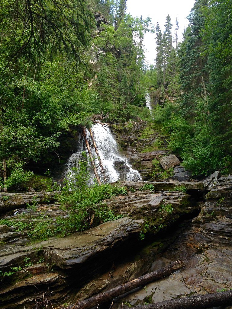
Elevator Shaft Drop-in is an uncommon/local name for a waterfall or drop feature located at coordinates 55.355, -122.6343 in northern British Columbia. There is limited to no widely published information about this feature in major trail or park databases. The feature appears to lie in a remote backcountry area; documented trailheads, measured height, and managed access are not readily available. Visitors should treat descriptions as tentative and expect route-finding and off-trail travel. Flow, accessibility, and exact character may be seasonal and variable.
Why This Waterfall Exists
Elevator shaft Drop-in flows over Misinchinka Group, a layered sedimentary rock layer deposited about 539 million to 1.0 billion years ago. Over time, the stream has worn through these layers at different rates, creating the step that forms the waterfall.
Trail & Hike Details
Trail Description
There is no verified, maintained trail description available from major trail resources. The approach likely involves unmarked routes, route-finding through forest and/or riparian terrain, and potentially steep or rugged sections near the drop. Expect uneven footing, muddy or wet approaches, and possibly dense vegetation. Because documented trail length and grade are unavailable, assume a remote backcountry approach rather than a short, maintained hike.
What to Expect
Remote backcountry conditions: limited or no signage, variable water flow (higher in spring/after rain), slippery rocks and steep banks near water, possible small cliff or steep drop where the waterfall occurs. Wildlife in the region may include bears (black and possibly grizzly), moose, wolves, and other boreal species. Cell coverage may be unreliable or nonexistent. Weather can change rapidly; snow may persist into late spring and return in fall.
Accessibility
Not wheelchair accessible. Approach likely requires off-trail travel and moderate to difficult terrain negotiation.
Frequently Asked Questions
🐶 Are Dogs Allowed at Elevator shaft Drop-in?
❌ Dogs are not allowed
Are There Any Fees or Permits Required?
🆖 No fees required
🏊 Is There Swimming at Elevator shaft Drop-in?
❌ Swimming is not allowed
When to Visit
Late spring through summer is often best for accessing remote northern locations (less snow on forest roads, longer daylight) and for reliable water flow. Early spring may have high flows and difficult access due to snowmelt. Fall can offer good conditions but shorter days and earlier snow. Winter access is likely challenging and may require specialized winter travel skills and equipment.
Seasonal Access
The best time to visit is Spring, Summer, Fall, and Winter. Check with the managing park or local authority for current conditions.
Safety Information
This feature is in a remote area. Primary hazards include: limited or no cell coverage; rapidly changing weather; cold water and swift currents; slippery rocks and steep drop-offs; wildlife encounters (bears and large ungulates); active logging roads and industrial activity; seasonal road closures due to snow or wet conditions. Use conservative planning: inform someone of your itinerary, carry emergency communication, avoid approaching edges of unstable banks, and do not take unnecessary risks near the water.
Current Water Conditions
Based on a Water Survey of Canada gauge 35.1 km away
144.0 m³/s
Current discharge — how much water is flowing
About average for this time of year
Based on 58 years of record
1.55 m
Water depth at gauge
7-Day Discharge Trend
What does this mean for your visit?
Flow is about average for this time of year.
About This Gauge
This gauge is on a regional waterway. Conditions at the falls may differ, especially after local rain.
7-Day Flow Outlook
Based on the WSC gauge PARSNIP RIVER ABOVE MISINCHINKA RIVER (35 km away).
Today
Moderate
156 m³/s
6/10Tomorrow
Moderate
165 m³/s
8/10Wed
Moderate
153 m³/s
8/10Thu
Moderate
148 m³/s
8/10Fri
Moderate
161 m³/s
6/10Sat
Moderate
155 m³/s
6/10Sun
Moderate
158 m³/s
6/10Best window: Tomorrow — moderate flow, partly cloudy (trip score 8/10).
Best time of year: this gauge typically runs highest from late April to mid July, peaking in May.
How we calculate this
This is a transparent outlook, not a precise forecast. We take the waterfall's current flow strength (how it ranks against its historical normal for today, from the nearest WSC stream gauge), carry that ranking forward along the gauge's seasonal curve, and nudge it for forecast rain. Confidence is highest for the next day or two and falls further out. Always check official conditions and your own judgment before visiting — high flows can be dangerous.
Weather Forecast
Location & Access
Getting There
This location is in a remote part of north-central/northern British Columbia. Specific published access routes, trailheads, or official signage are not documented. Access may require travel on unpaved forest service or logging roads, off-trail hiking, ATV travel, or floatplane. Expect limited or no cell service and few or no nearby services.
Get Directions on Google MapsParking
No known official parking area. If approaching by road, park only in safe pullouts well off the travel lane and avoid blocking forest service or logging operations. If arriving by aircraft or boat, use established landing areas and obtain any required permissions.
Elevation
1,347 metres above sea level
Coordinates
55.354967° N, -122.634255° W
Visitor Tips & Gear
1) Treat this as a remote backcountry visit: tell someone your plan and expected return time. 2) Check in with local BC Parks office, the regional forest district, or local outdoor clubs for any recent access information or closures. 3) Respect private land and active logging operations; obtain permission if required. 4) Carry bear spray and know how to use it; store food securely. 5) Wear sturdy footwear and bring rain layers, banks and rocks are likely slippery. 6) Consider a satellite communicator or PLB if venturing far off-grid. 7) If unfamiliar with the area, hire a local guide or contact local outdoor groups for guidance.
Where to Stay
Browse vacation cabins and private rentals nearby
Unique outdoor stays — tents, yurts, and treehouses
Rent a campervan or RV for your waterfall road trip
Some links are affiliate links. We may earn a commission at no extra cost to you.
Nearby Campground
Azouzetta Lake Lodge & Cabins
4.4 km away
Additional Information
Nearby Attractions
No specific nearby attractions are documented for this exact coordinate in major public trail resources. The broader region of northern British Columbia contains rivers, lakes, provincial parks and wilderness areas, check BC Parks and regional maps for formal sites and attractions nearer to your route.
Wildlife
Potential for black bear and grizzly bear, moose, wolves, lynx, and numerous bird species. Insects such as mosquitoes and blackflies may be significant in summer. Always follow wildlife safety protocols.
Nearby Waterfalls
Writing about Elevator shaft Drop-in? Embed this waterfall on your site for free.