Crescent Falls
Alberta • 27 m
By Armen Suny · Last verified Jun 2026
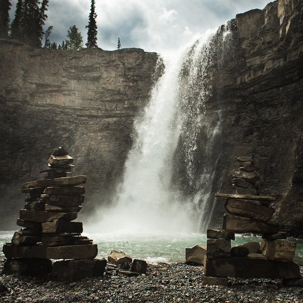
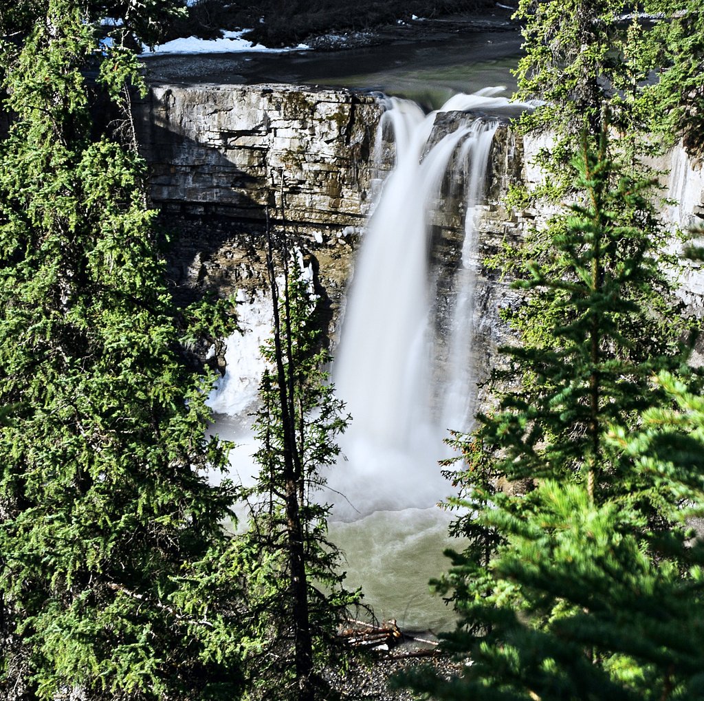
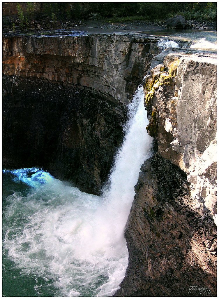
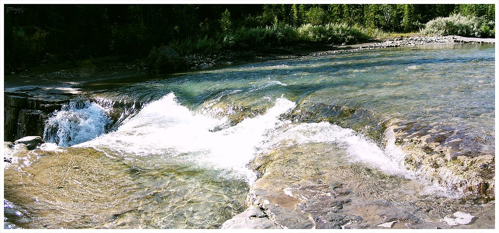

Photo Credits (5)
Difficulty
Easy
Trail Length
1.8 km
Trail Type
Out And Back
Elevation Gain
63 m
About Crescent Falls
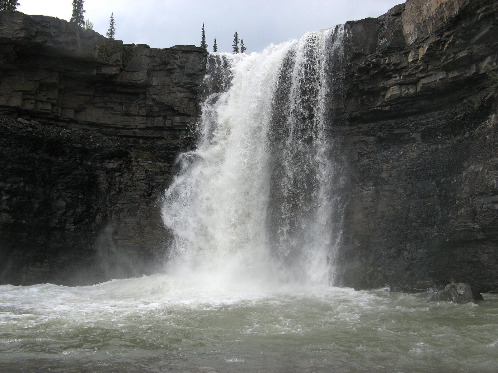
Crescent Falls is a series of two waterfalls located on the Bighorn River in the Bighorn River Canyon in west-central Alberta, Canada. They were originally called the Bighorn Falls, after the river they are located on. The current name is a reference to the crescent cliff over which they drop.
The Setting
Crescent Falls sits at 1,410 metres within Crescent Falls Provincial Recreation Area, in the mountains of Alberta. The falls drop 27 metres.
Why This Waterfall Exists
Crescent Falls flows over layered sedimentary rock, primarily sandstone, laid down about 66-101 million years ago. These soft rocks erode readily, allowing the stream to carve a 89-foot drop into the landscape.
Nearby Falls Worth Visiting
Allstones Falls (5 m) lies 11.1 kilometres to the south.
Trail & Hike Details
The Approach
The easy 1.8-km out-and-back trail gains 63 metres of elevation on the way to the falls.
Trail Description
From the parking turnout a short, well-defined trail leads to the primary upper overlook. The upper trail is relatively short but can be rocky and uneven; the upper viewpoint provides wide views of both tiers of the falls. Reaching the lower falls requires following a steeper, rougher path with loose rock and potential scrambling; this route is more hazardous and can be slippery when wet or icy. Trails are not highly developed beyond the main overlook and signage may be limited.
What to Expect
The falls cascade 27 metres over soft fine-grained rock.
Accessibility
The trail is not wheelchair accessible. Uneven terrain and elevation changes require steady footing.
Frequently Asked Questions
🐶 Are Dogs Allowed at Crescent Falls?
❌ Dogs are not allowed
Are There Any Fees or Permits Required?
🆖 No fees required
🏊 Is There Swimming at Crescent Falls?
❌ Swimming is not allowed
When to Visit
Late spring (snowmelt) through early summer for strongest flows; fall for foliage and quieter conditions; winter for frozen/ice features but expect icy trails and limited access. Midday to afternoon light often works well for photos of the falls, though conditions vary with season and weather.
Seasonal Access
The best time to visit is Spring, Summer, Fall, and Winter. Check with the managing park or local authority for current conditions.
Safety Information
Significant hazards include slippery rock surfaces, steep drop-offs, and fast-flowing cold water. Edges can be unstable; do not approach the lip or stand on wet rock. In winter, trails and overlooks can be very icy and exposed. Limited cell service and minimal facilities mean you should be self-reliant: bring supplies, tell someone your plans, and check road/forecast conditions before travel. Follow local signage and closures, and exercise caution descending to lower viewpoints.
Current Water Conditions
Based on a Water Survey of Canada gauge 26.9 km away
3.0 m³/s
Current discharge — how much water is flowing
About average for this time of year
Based on 50 years of record
0.93 m
Water depth at gauge
7-Day Discharge Trend
What does this mean for your visit?
Flow is about average for this time of year.
About This Gauge
This gauge is on a regional waterway. Conditions at the falls may differ, especially after local rain.
7-Day Flow Outlook
Based on the WSC gauge NORTH RAM RIVER AT FORESTRY ROAD (27 km away).
Today
Moderate
3.3 m³/s
5/10Tomorrow
Moderate
3.3 m³/s
5/10Tue
Moderate
3.1 m³/s
5/10Wed
Moderate
3.0 m³/s
5/10Thu
Moderate
3.0 m³/s
5/10Fri
Moderate
2.9 m³/s
5/10Sat
Moderate
2.5 m³/s
8/10Best window: Sat — moderate flow, sunny (trip score 8/10).
Best time of year: this gauge typically runs highest from early June to mid July, peaking in June.
How we calculate this
This is a transparent outlook, not a precise forecast. We take the waterfall's current flow strength (how it ranks against its historical normal for today, from the nearest WSC stream gauge), carry that ranking forward along the gauge's seasonal curve, and nudge it for forecast rain. Confidence is highest for the next day or two and falls further out. Always check official conditions and your own judgment before visiting — high flows can be dangerous.
Weather Forecast
Location & Access
Getting There
Crescent Falls is accessed from the Bighorn/Forestry roads in west-central Alberta (David Thompson/Bighorn area). There is a signed turnout and parking area off the main access road; follow the short footpath from the parking area to the upper overlook. Expect limited or no cell service in the area, check current road conditions before traveling.
Get Directions on Google MapsParking
Small gravel parking area / turnout near the trailhead. Parking can fill on busy days; parking is informal and there are limited facilities (pit toilet may or may not be present). Vehicles should be parked fully off the roadway.
Elevation
1,410 metres above sea level
Coordinates
52.387237° N, -116.355673° W
Land Management
Managed by Parks Division, Alberta Forestry and Parks
Visitor Tips & Gear
Wear sturdy footwear with good grip; use caution near cliff edges and on wet rock. If you plan to descend to lower viewpoints, be prepared for steep, loose terrain and consider skipping that route in icy/wet conditions. Pack out all trash, bring water and a map, and tell someone your plans if heading into backcountry. Check local road conditions before you go, forestry roads and approaches can be rough or seasonally closed. Be mindful of wildlife and store food securely.
As an Amazon Associate, we earn from qualifying purchases.
This easy 1.8 km hike is straightforward — comfortable trail shoes and plenty of water should do. Icy conditions are common in winter — traction cleats are a smart addition.

Columbia Watertight II Rain Jacket
Packs into its own pocket, seam-sealed, and keeps you dry from spray and surprise rain.

Polarized Sunglasses (Knockaround)
Cuts glare off the water so you actually see the falls — and your photos turn out better too.

Earth Pak Waterproof Dry Bag
Keeps your phone and gear dry when waterfall mist soaks everything else.

Waterproof Phone Pouch (AiRunTech)
Cheap insurance — take photos right next to the falls without killing your phone.

Kahtoola MICROspikes
Cult-favorite traction cleats that grip ice and wet rock — essential for winter waterfall hikes.

JOBY GorillaPod Starter Kit
Wraps around railings and rocks for long-exposure waterfall shots — no flat surface needed.
Where to Stay
Browse vacation cabins and private rentals nearby
Unique outdoor stays — tents, yurts, and treehouses
Rent a campervan or RV for your waterfall road trip
Some links are affiliate links. We may earn a commission at no extra cost to you.
Nearby Campground
Walk-in Tenting
0.2 km away
Additional Information
Nearby Attractions
The area is within the greater Bighorn/David Thompson region, hiking, scenic lookouts, and backcountry access are available in the surrounding public lands. (Check maps for specific nearby trails and points of interest.)
Wildlife
Wildlife in the region may include black bear, grizzly bear (in some zones), moose, deer, elk, coyotes, and smaller mammals. Exercise usual wildlife precautions: make noise, carry bear spray where recommended, and store food securely.
Nearby Waterfalls
Writing about Crescent Falls? Embed this waterfall on your site for free.