Cliffview Falls
Ontario • 15 m
By Armen Suny · Last verified Oct 2026
Difficulty
Drive Up
About Cliffview Falls
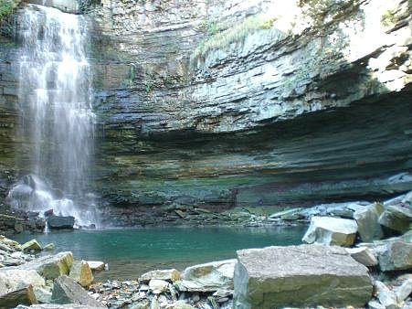
Cliffview Falls is a roughly 15 m (49 ft) ramp-shaped cascade in a narrow gorge on the Niagara Escarpment beside Cliffview Park, in the Westcliffe area of west Hamilton. The stream is a branch of Chedoke Creek fed by storm drainage, so it can dry up completely in summer. Most visitors see it from a viewing platform on the west rim of the gorge, right off the sidewalk.
The Setting
Cliffview Falls sits at 179 metres in the foothills of Ontario. The falls drop 15 metres.
Height: 49 feet
Nearby Falls Worth Visiting
Chedoke Falls (18 m) lies 0.6 kilometres to the east. Also nearby: Lower Westcliffe Falls (9 m, 0.2 km) and Lower Cliffview Falls (4 m, 0.2 km).
Trail & Hike Details
The Approach
No hiking required. Cliffview Falls is accessible by vehicle with a roadside viewing area.
Trail Description
The viewing platform on the west rim is about a two-minute walk from Cliffview Park, though leaves can hide the falls in summer. Reaching the base means taking the Chedoke Stairs (289 steel steps) from the northwest corner of the park down to Chedoke Golf Course, then following the creek about 200 m upstream with no marked trail. The Waterfalls of Ontario guide calls the base route difficult and dangerous, says it is not recommended, and notes it may be prohibited.
What to Expect
The falls drop 15 metres. Dogs are welcome.
Accessibility
This waterfall is viewable from a vehicle-accessible area. No hiking is required.
Frequently Asked Questions
🐶 Are Dogs Allowed at Cliffview Falls?
✅ Dogs are allowed
City of Hamilton by-law requires dogs to be leashed in city parks except in designated leash-free areas.
Are There Any Fees or Permits Required?
🆖 No fees required
🏊 Is There Swimming at Cliffview Falls?
❌ Swimming is not allowed
When to Visit
Spring and after heavy rains for best water flow; early fall for fall colours. Summer visits are fine but flow may be lower in dry periods. Winter can produce ice formations but access and footing are hazardous, avoid unless experienced with winter hiking and ice conditions.
Seasonal Access
The best time to visit is Spring, Summer, and Fall. Winter access may be limited. Check with the managing park or local authority for current conditions.
Safety Information
The gorge walls are steep and the rock is slippery and loose; stay on the platform and sidewalk. The off-trail route to the base is rated difficult and dangerous, and ice makes the stairs and gorge hazardous in winter.
Current Water Conditions
These readings come from the Water Survey of Canada gauge on Spencer Creek, 5.1 km away, not on Cliffview Falls's own stream. Use them as a sign of whether the area is running wet or dry.
0.7 m³/s
Current discharge — how much water is flowing
About average for this time of year
Based on 42 years of record
6.08 m
Water depth at gauge
7-Day Discharge Trend
What does this mean for your visit?
Flow is about average for this time of year.
About This Gauge
7-Day Flow Outlook
Based on the WSC gauge SPENCER CREEK AT DUNDAS (5 km away).
Today
Moderate
0.8 m³/s
8/10Tomorrow
Moderate
0.8 m³/s
6/10Sat
Moderate
0.8 m³/s
6/10Sun
Moderate
1.0 m³/s
6/10Mon
Moderate
1.0 m³/s
6/10Tue
Moderate
0.9 m³/s
6/10Wed
Moderate
0.9 m³/s
6/10Best window: Today — moderate flow, mainly sunny (trip score 8/10).
Best time of year: this gauge typically runs highest from mid February to early May, peaking in April.
How we calculate this
This is a transparent outlook, not a precise forecast. We take the waterfall's current flow strength (how it ranks against its historical normal for today, from the nearest WSC stream gauge), carry that ranking forward along the gauge's seasonal curve, and nudge it for forecast rain. Confidence is highest for the next day or two and falls further out. Always check official conditions and your own judgment before visiting — high flows can be dangerous.
Know when to go.
Get a free email alert when waterfalls near Hamilton hit peak flow. We only send when conditions are worth the trip — no weekly newsletters, no spam.
Weather Forecast
Location & Access
Getting There
Drive to Cliffview Park at Scenic Drive and Upper Paradise Road on the Hamilton Mountain. The viewing platform is on the west side of the ravine next to the park.
Get Directions on Google MapsParking
Park at Cliffview Park. The Chedoke Municipal Golf Course below the escarpment is the parking option if you are walking the Chedoke Stairs.
Elevation
179 metres above sea level
Coordinates
43.244327° N, -79.907817° W
Visitor Tips & Gear
View from the platform rather than trying to reach the base. Visit in spring or after rain, since the creek can run dry in summer. Combine it with other west Hamilton falls such as Chedoke Falls and Lower Cliffview Falls.
Where to Stay
Browse vacation cabins and private rentals nearby
Unique outdoor stays — tents, yurts, and treehouses
Rent a campervan or RV for your waterfall road trip
Some links are affiliate links. We may earn a commission at no extra cost to you.
Nearby Campground
Lost Forest Park & Camping Resort
14.8 km away
Additional Information
Nearby Attractions
The Hamilton area is known for many waterfalls and escarpment trails (e.g., Webster Falls, Tew's Falls, Tiffany Falls), these better-known sites often have maintained trails and official parking. Check local conservation authority and parks for mapped sites.
Wildlife
Typical southern Ontario species: white-tailed deer, raccoons, squirrels, various songbirds, and small reptiles/amphibians. Be aware of ticks in warmer months.
Cities near Cliffview Falls
Nearby Waterfalls
Writing about Cliffview Falls? Embed this waterfall on your site for free.