Photo Credits (5)
Difficulty
Easy
Trail Length
3.1 km
Trail Type
Loop
Elevation Gain
66 m
About Chutes Dufferin
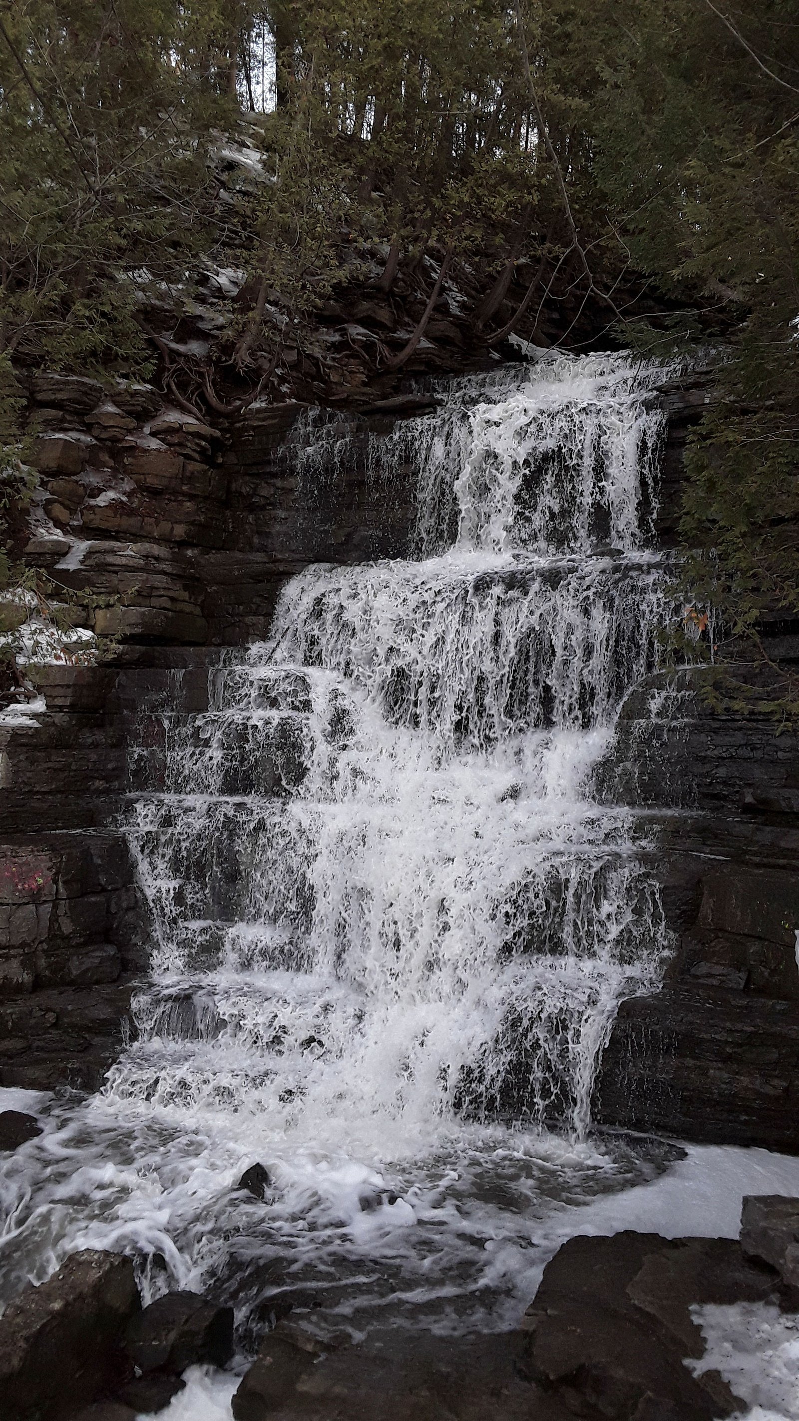
Chutes Dufferin is a set of cascades and small falls located in Quebec near the Ontario–Quebec border (coordinates 45.5844, -75.4193). The site is in a wooded, riverine setting and is most notable for seasonal flow variation, high in spring melt and lower in late summer. Facilities and formal development appear limited; access is via local roads and a short walk from a roadside parking or pullout. Exact published height measurements are not readily available.
Why This Waterfall Exists
Chutes Dufferin flows over hard banded metamorphic rock, primarily gneiss, laid down over 1.4-1.6 billion years ago. These resistant rocks form a durable ledge that water cannot easily wear away, creating the falls where softer material downstream has already eroded.
Trail & Hike Details
The Approach
The easy 3.1-km loop trail gains 66 metres of elevation on the way to the falls.
Trail Description
A short, generally easy walk from a nearby parking area or pullout follows a well-worn path or informal track to viewpoints along the river. The path may be uneven, rocky and muddy in places; in winter it can be icy and require traction. There is no widely documented long hiking approach, visits are typically short (viewing and short exploration). Specific signage, boardwalks or developed viewing platforms may be limited or absent.
What to Expect
Expect a small series of cascades and rocky ledges rather than a large single-drop waterfall. Flow is highest in spring during snowmelt and after heavy rains; late summer flows may be reduced. Surrounding habitat is mixed woodland and river-edge brush. Facilities are minimal; bring what you need. Wild and slippery rock surfaces and swift currents near the falls are hazards, exercise caution.
Accessibility
The trail is not wheelchair accessible. Uneven terrain and elevation changes require steady footing.
Frequently Asked Questions
🐶 Are Dogs Allowed at Chutes Dufferin?
❌ Dogs are not allowed
Are There Any Fees or Permits Required?
🆖 No fees required
🏊 Is There Swimming at Chutes Dufferin?
❌ Swimming is not allowed
When to Visit
Spring (late March–May) for highest flows and dramatic water; fall for foliage colors. Winter can offer striking frozen formations for experienced, cautious visitors. Summer offers easy access but lower flows.
Seasonal Access
The best time to visit is Spring, Summer, Fall, and Winter. Check with the managing park or local authority for current conditions.
Safety Information
Hazards include slippery and unstable rocks, fast-flowing water, cold water temperatures, and variable trail footing. In winter, ice and snow increase risk; in spring, high water and strong currents are possible. There may be limited or no cell service and no on-site emergency services; tell someone your plans and estimated return time. Obey any posted signs and do not enter restricted or private property.
Current Water Conditions
0.1 m³/s
Current discharge — how much water is flowing
6.66 m
Water depth at gauge
7-Day Discharge Trend
About This Gauge
This gauge is on a nearby waterway and may not reflect exact conditions at the falls.
7-Day Flow Outlook
Based on the WSC gauge BECKETTS CREEK NEAR CUMBERLAND ESTATES (11 km away).
Today
Moderate
0.1 m³/s
8/10Tomorrow
Moderate
0.1 m³/s
8/10Tue
Moderate
0.1 m³/s
6/10Wed
Moderate
0.1 m³/s
6/10Thu
Moderate
0.1 m³/s
8/10Fri
Moderate
0.1 m³/s
6/10Sat
Moderate
0.1 m³/s
6/10Best window: Today — moderate flow, cloudy (trip score 8/10).
How we calculate this
This is a transparent outlook, not a precise forecast. We take the waterfall's current flow strength (how it ranks against its historical normal for today, from the nearest WSC stream gauge), carry that ranking forward along the gauge's seasonal curve, and nudge it for forecast rain. Confidence is highest for the next day or two and falls further out. Always check official conditions and your own judgment before visiting — high flows can be dangerous.
Know when to go.
Get a free email alert when waterfalls near Ottawa hit peak flow. We only send when conditions are worth the trip — no weekly newsletters, no spam.
Weather Forecast
Location & Access
Getting There
Located roughly 20 miles east of downtown Ottawa, Chutes Dufferin is reached via local roads off the regional highway network. Use the provided coordinates (45.5844, -75.4193) in a mapping app to navigate to the nearest roadside parking or pullout. Roads near the site may be narrow; follow local signage and drive slowly. Public transit access is unlikely.
Get Directions on Google MapsParking
Parking appears to be informal (small lot or roadside pullout). Expect limited or no official facilities (no restrooms, no fee booth). Park only in designated areas and avoid blocking the road.
Elevation
116 metres above sea level
Coordinates
45.584374° N, -75.419343° W
Visitor Tips & Gear
• Wear sturdy, grippy footwear, rocks and trails can be slippery. • Expect limited or no facilities: bring water, snacks, and pack out trash. • Cell coverage may be spotty, download directions or save the coordinates beforehand. • Stay on established paths and respect private property, many rural falls sit near private land. • Be cautious near the water: currents, undercut rock, and slippery surfaces create hazard. • In winter, the falls may form ice features but ice can be unstable, avoid walking on frozen river surfaces.
As an Amazon Associate, we earn from qualifying purchases.
This easy 3.1 km hike is straightforward — comfortable trail shoes and plenty of water should do. Icy conditions are common in winter — traction cleats are a smart addition.

Columbia Watertight II Rain Jacket
Packs into its own pocket, seam-sealed, and keeps you dry from spray and surprise rain.

Polarized Sunglasses (Knockaround)
Cuts glare off the water so you actually see the falls — and your photos turn out better too.

Earth Pak Waterproof Dry Bag
Keeps your phone and gear dry when waterfall mist soaks everything else.

Waterproof Phone Pouch (AiRunTech)
Cheap insurance — take photos right next to the falls without killing your phone.

Kahtoola MICROspikes
Cult-favorite traction cleats that grip ice and wet rock — essential for winter waterfall hikes.

JOBY GorillaPod Starter Kit
Wraps around railings and rocks for long-exposure waterfall shots — no flat surface needed.
Where to Stay
Browse vacation cabins and private rentals nearby
Unique outdoor stays — tents, yurts, and treehouses
Rent a campervan or RV for your waterfall road trip
Some links are affiliate links. We may earn a commission at no extra cost to you.
Nearby Campground
Camping L'Ange-Gardien
7.4 km away
Additional Information
Nearby Attractions
Closest major centres noted by distance include Ottawa (~20.1 miles), Cornwall (~56.8 miles) and Akwesasne (~62.1 miles). Other nearby local attractions may include regional parks and riverfront towns, check local tourism resources for current options.
Wildlife
Typical rural river-edge wildlife may be present (songbirds, small mammals, deer, and possibly beaver). Watch for ticks and seasonal insects. Do not approach or feed wildlife.
Cities near Chutes Dufferin
Nearby Waterfalls
Writing about Chutes Dufferin? Embed this waterfall on your site for free.