Photo Credits (2)
Difficulty
Easy
Trail Length
0.8 km
Trail Type
Out And Back
Elevation Gain
15 m
About Chutes de Mansonville
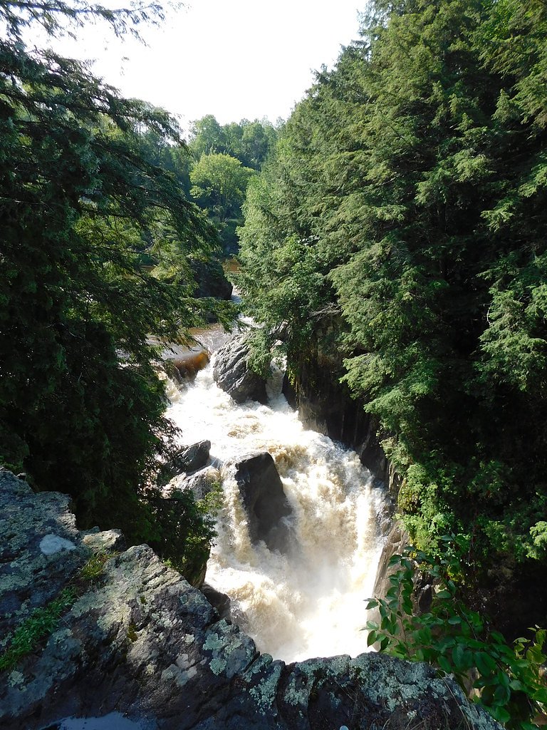
Chutes de Mansonville (Mansonville Falls) is a small, scenic cascade near the village of Mansonville in the Eastern Townships of Quebec. The falls drop through a rocky gorge and are popular for short visits and photography. Flow is typically highest in spring snowmelt and after heavy rains. Facilities at the site are limited and conditions can be slippery and icy in cold weather.
The Setting
Chutes de Mansonville sits at 179 metres in the foothills of Quebec. The falls drop 4 metres.
Why This Waterfall Exists
Chutes de Mansonville flows over layered sedimentary rock laid down about 444 million to 1.0 billion years ago. Over time, the stream has worn through these layers at different rates, creating a 13-foot drop that forms the waterfall.
Trail & Hike Details
The Approach
The easy 0.8-km out-and-back trail gains 15 metres of elevation on the way to the falls.
Trail Description
A short, mostly well-defined path leads from parking/roadside to viewpoints of the cascade and the gorge. The trail is relatively short and generally considered easy, but there may be steps, uneven rock surfaces, and muddy sections after rain. There may be informal routes down to water level; these can be steep and slippery and are not recommended for inexperienced hikers.
What to Expect
The falls drop a gentle 4 metres over layered sedimentary rock.
Accessibility
The trail is short and relatively flat, but the surface may be uneven. Contact the managing agency for accessibility details.
Frequently Asked Questions
🐶 Are Dogs Allowed at Chutes de Mansonville?
❌ Dogs are not allowed
Are There Any Fees or Permits Required?
🆖 No fees required
🏊 Is There Swimming at Chutes de Mansonville?
❌ Swimming is not allowed
When to Visit
Late spring (high water/after snowmelt) for the best flow, and fall for foliage color. Summer is pleasant but flows may be lower; winter can be scenic but icy and requires extra caution.
Seasonal Access
The best time to visit is Spring, Summer, Fall, and Winter. Check with the managing park or local authority for current conditions.
Safety Information
Hazards can include slippery rocks and trails, steep drop-offs near the gorge, fast cold water, and seasonal ice. Stay on established paths and viewing areas, supervise children closely, and keep a safe distance from edges. Check local conditions before visiting and avoid approach to the water during high flow or flooding. If unfamiliar with the area, use the provided coordinates and local signage; rescue or emergency response may be delayed in remote areas.
7-Day Flow Outlook
Based on the WSC gauge YAMASKA SUD-EST (RIVIERE) AU PONT-ROUTE 202 A COWANSVILLE (33 km away).
Best time of year: this gauge typically runs highest from mid March to mid May, peaking in April.
How we calculate this
This is a transparent outlook, not a precise forecast. We take the waterfall's current flow strength (how it ranks against its historical normal for today, from the nearest WSC stream gauge), carry that ranking forward along the gauge's seasonal curve, and nudge it for forecast rain. Confidence is highest for the next day or two and falls further out. Always check official conditions and your own judgment before visiting — high flows can be dangerous.
Know when to go.
Get a free email alert when waterfalls near Sherbrooke hit peak flow. We only send when conditions are worth the trip — no weekly newsletters, no spam.
Weather Forecast
Location & Access
Getting There
The falls are located near coordinates 45.0502, -72.3891, just outside the village of Mansonville (municipality of Potton) in the Eastern Townships, Quebec. From Mansonville follow local roads toward the river/park signage; the site is reachable by car from nearby towns (North Troy ~3.3 miles south in Vermont, Newport Center ~8.3 miles, Newport ~13.1 miles). Use a map app and the coordinates for precise directions.
Get Directions on Google MapsParking
Parking is limited and may be roadside or a small local lot near the trailhead. Expect minimal facilities (no guaranteed restrooms or formal visitor center). Park legally and avoid blocking private driveways.
Elevation
179 metres above sea level
Coordinates
45.050218° N, -72.389083° W
Visitor Tips & Gear
• Wear sturdy shoes with good traction, rocks and trail sections can be slippery. • Spring offers high flow and dramatic scenery; fall offers good color. Winter requires caution due to ice. • Bring a camera and layers; weather can change quickly. • Respect private property and stay on marked or obvious public paths. • No guaranteed facilities: bring water and washroom plans accordingly. • Cellular reception may be spotty in places.
As an Amazon Associate, we earn from qualifying purchases.
For this easy 0.8 km trail, lightweight trail shoes and a water bottle are usually sufficient. Icy conditions are common in winter — traction cleats are a smart addition.

Columbia Watertight II Rain Jacket
Packs into its own pocket, seam-sealed, and keeps you dry from spray and surprise rain.

Polarized Sunglasses (Knockaround)
Cuts glare off the water so you actually see the falls — and your photos turn out better too.

Earth Pak Waterproof Dry Bag
Keeps your phone and gear dry when waterfall mist soaks everything else.

Waterproof Phone Pouch (AiRunTech)
Cheap insurance — take photos right next to the falls without killing your phone.

Kahtoola MICROspikes
Cult-favorite traction cleats that grip ice and wet rock — essential for winter waterfall hikes.

JOBY GorillaPod Starter Kit
Wraps around railings and rocks for long-exposure waterfall shots — no flat surface needed.
Where to Stay
Browse vacation cabins and private rentals nearby
Unique outdoor stays — tents, yurts, and treehouses
Rent a campervan or RV for your waterfall road trip
Some links are affiliate links. We may earn a commission at no extra cost to you.
Nearby Campground
Camping Nature Plein-Air
4.4 km away
Additional Information
Nearby Attractions
The Eastern Townships region offers other attractions within driving distance such as Mont Sutton (skiing/hiking), nearby lakes and provincial parks, and village amenities in Mansonville and surrounding towns. Use local tourism resources for current attraction details.
Wildlife
Typical regional wildlife includes white-tailed deer, beavers, small mammals, and a variety of songbirds and raptors. Black bear sightings are possible in the region; practice standard bear-aware precautions.
Cities near Chutes de Mansonville
Nearby Waterfalls
Writing about Chutes de Mansonville? Embed this waterfall on your site for free.