Photo Credits (4)
Difficulty
Moderate
Trail Length
1.9 km
Trail Type
Out And Back
Elevation Gain
96 m
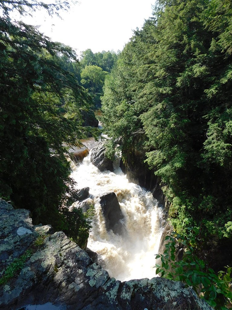
About Chute du Pékan
Chute du Pékan is a waterfall located in southern Quebec near the U.S. border (coordinates 45.0973, -72.5491). It sits in a rural landscape roughly 11.1 miles from North Troy (VT), 17.3 miles from Newport Center (VT) and 20.0 miles from Enosburg Falls (VT) per the provided distances. Public documentation about the site (official park pages or widely used trail guides) is limited; the falls appear to be on a small river or stream and are likely accessed via local roads and a short unmarked path. Many specifics, including an exact measured height and an officially maintained trail, are not well documented and therefore are reported here with appropriate caution.
Why This Waterfall Exists
Chute du Pékan flows over cemented gravel rock, primarily conglomerate and sandstone, laid down about 444 million to 1.0 billion years ago. These soft rocks erode readily, allowing the stream to carve a vertical drop into the landscape.
Nearby Falls Worth Visiting
Chutes de Mansonville (4 m) lies 13.7 kilometres to the east.
Trail & Hike Details
The Approach
The moderate 1.9-km out-and-back trail gains 96 metres of elevation on the way to the falls.
Trail Description
There does not appear to be a widely maintained, signed trail to Chute du Pékan in major trail databases. Access may involve a short, informal footpath from a roadside pullout or a brief bushwhack over uneven terrain. Expect natural surfaces (mud, roots, rocks), potentially steep or slippery sections near the water, and minimal infrastructure (no boardwalks or guardrails). Because mapping and visitor reports are sparse, exact route details can vary and may require local knowledge or cautious route-finding.
What to Expect
• A rural setting with a natural waterfall on a small river or stream. Flow will vary seasonally (higher in spring runoff, lower in late summer). • Minimal facilities: likely no toilets, signage, or trash bins. • Uneven ground, wet and slippery rocks near the falls, and possibly dense vegetation on approach. • Limited or spotty cell coverage in some areas. • In winter the falls may be partially or fully frozen and access can be icy and hazardous.
Accessibility
The trail is not wheelchair accessible. Uneven terrain and elevation changes require steady footing.
Frequently Asked Questions
🐶 Are Dogs Allowed at Chute du Pékan?
❌ Dogs are not allowed
Are There Any Fees or Permits Required?
🆖 No fees required
🏊 Is There Swimming at Chute du Pékan?
❌ Swimming is not allowed
When to Visit
Spring (late March to May) for highest water flow during snowmelt; fall (September–October) for color and cooler, stable weather. Summer can be pleasant but flows may be lower; winter offers ice-formation views but access is more hazardous and may require winter gear.
Seasonal Access
The best time to visit is Spring, Summer, Fall, and Winter. Check with the managing park or local authority for current conditions.
Safety Information
• Rocks near waterfalls are slippery, avoid getting too close to the edge. • Water currents and undercut rocks can be hazardous; do not assume it is safe to swim. • Seasonal high flows (spring) increase risk near the water. • In winter, ice can form but may be unstable, avoid walking on ice unless you are experienced and the ice is confirmed safe. • Limited facilities and cell coverage mean you should be self-sufficient and prepared for emergencies. • Respect private property and posted signs; trespassing can be dangerous and illegal. • Hunting seasons in fall may increase noise and risk; wear bright clothing and be aware of calendar and local regs.
7-Day Flow Outlook
Based on the WSC gauge YAMASKA SUD-EST (RIVIERE) AU PONT-ROUTE 202 A COWANSVILLE (20 km away).
Best time of year: this gauge typically runs highest from mid March to mid May, peaking in April.
How we calculate this
This is a transparent outlook, not a precise forecast. We take the waterfall's current flow strength (how it ranks against its historical normal for today, from the nearest WSC stream gauge), carry that ranking forward along the gauge's seasonal curve, and nudge it for forecast rain. Confidence is highest for the next day or two and falls further out. Always check official conditions and your own judgment before visiting — high flows can be dangerous.
Know when to go.
Get a free email alert when waterfalls near Sherbrooke hit peak flow. We only send when conditions are worth the trip — no weekly newsletters, no spam.
Weather Forecast
Location & Access
Getting There
Use the coordinates (45.0973, -72.5491) for GPS navigation. The falls are in rural Quebec close to the Vermont border; approach is likely via local provincial roads rather than major highways. If you are coming from the U.S., expect to cross the international border, carry appropriate ID (passport or other accepted travel documents). Exact turnoffs and approach routes are not consistently documented online, so plan for limited signage and possible unpaved access roads.
Get Directions on Google MapsParking
Parking information is not well documented. Expect limited roadside parking or informal pullouts near the access point. Do not park blocking driveways or private gateways; use clearly allowed pullouts only. If you are unsure about parking locations, park in a safe, legal spot and walk to the site.
Elevation
511 metres above sea level
Coordinates
45.097255° N, -72.549073° W
Visitor Tips & Gear
• Carry identification (passport if crossing from the U.S.). • Wear sturdy, waterproof footwear with good traction; expect slippery rocks and mud. • Respect private property, do not trespass. If access appears to cross private land, seek permission. • Bring bug spray in warm months (mosquitoes, black flies, ticks). Check for ticks after visits. • Leave no trace: pack out all trash and avoid disturbing vegetation or wildlife. • If visiting in winter, use ice cleats and be very cautious near frozen water; do not assume ice is safe. • Let someone know your plans when visiting remote spots and consider bringing a paper map in case GPS fails.
As an Amazon Associate, we earn from qualifying purchases.
With 1.9 km and 96 m of elevation gain, sturdy boots and trekking poles will help on this moderate trail. Icy conditions are common in winter — traction cleats are a smart addition.

Columbia Watertight II Rain Jacket
Packs into its own pocket, seam-sealed, and keeps you dry from spray and surprise rain.

Polarized Sunglasses (Knockaround)
Cuts glare off the water so you actually see the falls — and your photos turn out better too.

Earth Pak Waterproof Dry Bag
Keeps your phone and gear dry when waterfall mist soaks everything else.

Waterproof Phone Pouch (AiRunTech)
Cheap insurance — take photos right next to the falls without killing your phone.

Timberland Euro Sprint Mid Waterproof
Trusted waterproof boot with premium leather and grippy rubber sole — reliable on rocky, wet trails.

TrailBuddy Trekking Poles
Lightweight aluminum, cork grips, and flip-locks that actually hold — a best-seller for good reason.
Where to Stay
Browse vacation cabins and private rentals nearby
Unique outdoor stays — tents, yurts, and treehouses
Rent a campervan or RV for your waterfall road trip
Some links are affiliate links. We may earn a commission at no extra cost to you.
Nearby Campground
Huttopia Sutton
2.8 km away
Additional Information
Nearby Attractions
Nearby towns include North Troy, Newport Center and Enosburg Falls (all in Vermont), and other rural attractions in the Quebec–Vermont border region. Exact nearby parks or named attractions are not consistently listed in major trail resources for this specific waterfall.
Wildlife
Expect typical rural Quebec/Vermont-border wildlife: white-tailed deer, moose (in some areas), red fox, small mammals, a variety of songbirds, and insects (mosquitoes, black flies, ticks). Be cautious of larger wildlife and observe from a distance.
Cities near Chute du Pékan
Nearby Waterfalls
Writing about Chute du Pékan? Embed this waterfall on your site for free.