Photo Credits (3)
Difficulty
Moderate
Trail Length
6.9 km
Trail Type
Out And Back
Elevation Gain
337 m
About Chute Vauréal
Chute Vauréal is a remote waterfall in the Côte-Nord region of Quebec, Canada, located in the general vicinity of Natashquan. The fall sits in a boreal/coastal landscape and is most notable for its natural, undeveloped setting. Seasonal flow can vary widely: higher in spring during snowmelt and after heavy rain, lower in late summer and early fall. Access appears to be along local roads and rough trails rather than a developed park site; signage and visitor facilities may be minimal or absent.
The Setting
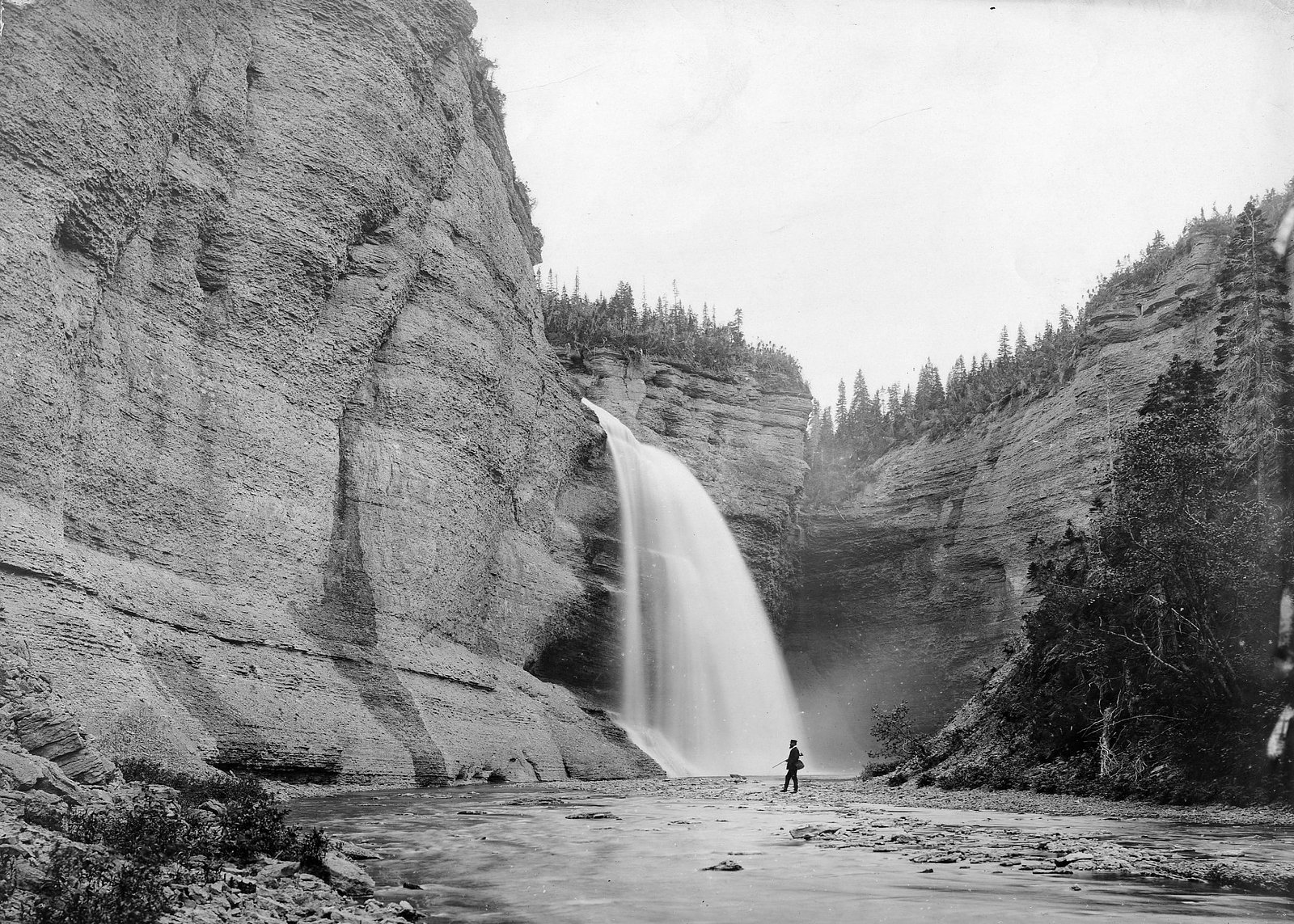
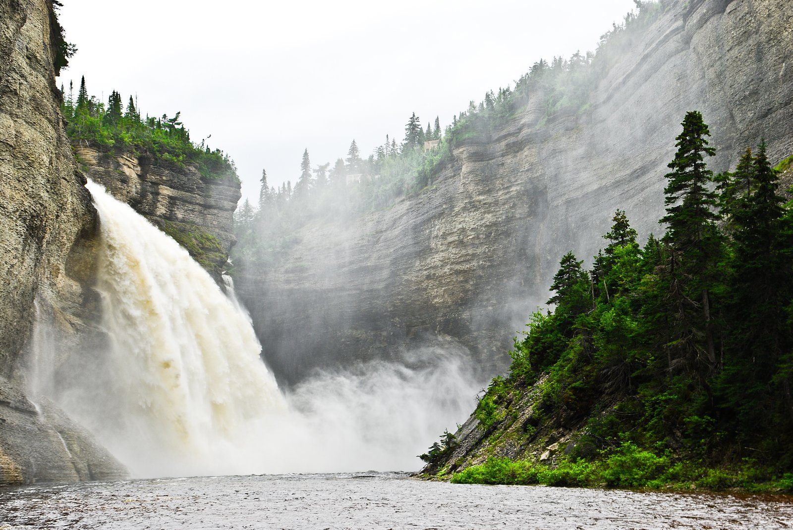
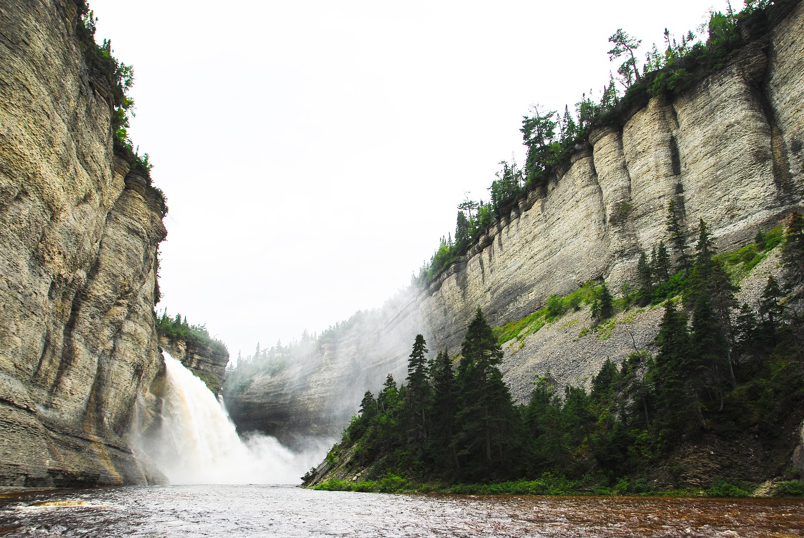
Chute Vauréal sits at 140 metres within Anticosti National Park, in the coastal lowlands of Quebec. At 76 metres, it is among the taller waterfalls in Quebec.
Why This Waterfall Exists
Chute Vauréal flows over layered sedimentary rock laid down about 444-458 million years ago. Over time, the stream has worn through these layers at different rates, creating a 249-foot drop that forms the waterfall.
Trail & Hike Details
The Approach
The moderate 6.9-km out-and-back trail gains 337 metres of elevation on the way to the falls.
Trail Description
Approaches to Chute Vauréal are likely on unmaintained or lightly used forest tracks and short footpaths. Trails (if present) may be rocky, muddy, uneven, and not waymarked. Expect a rustic, backcountry-style approach rather than an established boardwalk or paved viewpoint. Short bushwhacks or stream crossings may be required depending on the route chosen.
What to Expect
The falls plunge 76 metres over layered sedimentary rock.
Accessibility
The trail involves steep, uneven terrain with significant elevation change and is not accessible to mobility devices.
Frequently Asked Questions
🐶 Are Dogs Allowed at Chute Vauréal?
❌ Dogs are not allowed
Are There Any Fees or Permits Required?
🆖 No fees required
🏊 Is There Swimming at Chute Vauréal?
❌ Swimming is not allowed
When to Visit
Spring (high water during snowmelt) and early summer (accessible roads and fuller flow) provide the most dramatic waterfall conditions. Fall offers good colors and typically stable weather. Winter may show interesting ice formations but access can be difficult or unsafe due to snow, ice, and road closures.
Seasonal Access
The best time to visit is Spring, Summer, Fall, and Winter. Check with Anticosti National Park for current conditions.
Safety Information
Hazards include slippery and unstable rocks near the falls, fast currents, cold water, steep or unmaintained trails, poor or no cell coverage, rapidly changing weather, and biting insects in summer. Emergency services may be distant, carry a first-aid kit, tell someone your plans, and avoid risky behavior near edges or in the water. In winter, expect icy conditions and potential avalanche risk on steep slopes; exercise winter-specific precautions.
Know when to go.
Get a free email alert when waterfalls near Natashquan hit peak flow. We only send when conditions are worth the trip — no weekly newsletters, no spam.
Weather Forecast
Location & Access
Getting There
Chute Vauréal is located on the northern shore of the Gulf of St. Lawrence in the Natashquan area of Côte-Nord, Quebec (approximate coordinates 49.5602, -62.6934). The nearest service center is the village of Natashquan. Expect to travel on Route 138 and then on secondary or logging roads; the final approach may be a short unmarked track or footpath. Visitors should plan for a long drive from major towns and verify local access conditions ahead of time. Cell coverage may be intermittent.
Get Directions on Google MapsParking
Parking is likely informal/primitive (roadside or small pullout). There may be no established lot, signage, or facilities. Park safely off the road and avoid blocking gates or private driveways.
Elevation
140 metres above sea level
Coordinates
49.560215° N, -62.693416° W
Land Management
Managed by Ministère de l'Environnement, de la Lutte contre les changements climatiques, de la Faune et des Parcs, Direction des parcs
Visitor Tips & Gear
1) Plan ahead: confirm local road conditions and any private property boundaries before you go. 2) Travel with a detailed map/GPS and offline directions; mobile reception may be unreliable. 3) Wear sturdy, non-slip footwear and be cautious on wet rocks and stream banks. 4) Bring insect repellent for summer months and warm layers for shoulder seasons. 5) Respect private land and any posted signs; leave no trace. 6) If you are unfamiliar with remote travel, go with someone experienced or inform someone of your plans and expected return time.
As an Amazon Associate, we earn from qualifying purchases.
With 6.9 km and 337 m of elevation gain, sturdy boots and trekking poles will help on this moderate trail. Icy conditions are common in winter — traction cleats are a smart addition.

Columbia Watertight II Rain Jacket
Packs into its own pocket, seam-sealed, and keeps you dry from spray and surprise rain.

Polarized Sunglasses (Knockaround)
Cuts glare off the water so you actually see the falls — and your photos turn out better too.

Earth Pak Waterproof Dry Bag
Keeps your phone and gear dry when waterfall mist soaks everything else.

Waterproof Phone Pouch (AiRunTech)
Cheap insurance — take photos right next to the falls without killing your phone.

Timberland Euro Sprint Mid Waterproof
Trusted waterproof boot with premium leather and grippy rubber sole — reliable on rocky, wet trails.

TrailBuddy Trekking Poles
Lightweight aluminum, cork grips, and flip-locks that actually hold — a best-seller for good reason.
Where to Stay
Browse vacation cabins and private rentals nearby
Unique outdoor stays — tents, yurts, and treehouses
Rent a campervan or RV for your waterfall road trip
Some links are affiliate links. We may earn a commission at no extra cost to you.
Nearby Campground
Camping Baie-de-la-Tour
18.6 km away
Additional Information
Nearby Attractions
The coastal village of Natashquan (services, local culture), coastal scenery along the Gulf of St. Lawrence, boreal forest landscapes, river fishing opportunities in the region. Nearby attractions are generally remote and low-service.
Wildlife
Common regional species may include migratory and coastal birds, small mammals, moose, and black bear. Insect activity (mosquitoes, blackflies) can be heavy in summer. Exercise normal wildlife precautions.
Cities near Chute Vauréal
Nearby Waterfalls
Writing about Chute Vauréal? Embed this waterfall on your site for free.