Difficulty
Easy
Trail Length
3.2 km
Trail Type
Out And Back
Elevation Gain
46 m
About Chute de la Baie-de-la-Tour
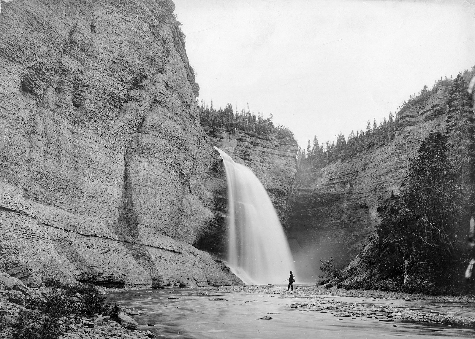
Chute de la Baie-de-la-Tour is a remote coastal/river waterfall on the Côte-Nord of Quebec near the Gulf of St. Lawrence. It lies in a sparsely populated area approximately 64.2 miles from the town of Natashquan. Reports and mapping indicate a waterfall where a river drops toward Baie de la Tour; however, published, detailed measurements and an official developed visitor site are not readily available. Access appears to be informal and may involve coastal roads, forest/ logging roads, or travel by boat. Visitors should expect limited or no services on site.
Why This Waterfall Exists
Chute de la Baie-de-la-Tour flows over layered sedimentary rock laid down about 444-458 million years ago. Over time, the stream has worn through these layers at different rates, creating the step that forms the waterfall.
Nearby Falls Worth Visiting
Chute Vauréal (76 m) lies 13.7 kilometres to the northwest.
Trail & Hike Details
The Approach
The easy 3.2-km out-and-back trail gains 46 metres of elevation on the way to the falls.
Trail Description
There is no widely published, maintained trail to Chute de la Baie-de-la-Tour. Reports and mapping suggest the site is reached via unmarked footpaths, rough forest roads, or by watercraft along the coast or river. Expect uneven terrain, possible bushwhacking, and no signage. If you require a maintained trail, local outfitters or municipal offices in Natashquan may be able to confirm any informal access routes.
What to Expect
A remote, natural waterfall in a coastal river/estuary environment. Facilities (toilets, handrails, viewing platforms) are unlikely. Terrain near the fall may be rocky and slippery, with mixed forest and coastal scrub. Water flow will be highest in spring (snowmelt) and after heavy rains; tidal influence may affect lower reaches if the fall is close to the bay. In summer expect insects (black flies, mosquitoes). Cell service may be intermittent or absent.
Accessibility
The trail is not wheelchair accessible. Uneven terrain and elevation changes require steady footing.
Frequently Asked Questions
🐶 Are Dogs Allowed at Chute de la Baie-de-la-Tour?
❌ Dogs are not allowed
Are There Any Fees or Permits Required?
🆖 No fees required
🏊 Is There Swimming at Chute de la Baie-de-la-Tour?
❌ Swimming is not allowed
When to Visit
Late spring for higher flows from snowmelt and early summer for more accessible conditions. Early fall can offer lower crowds and fall color. Winter access is likely difficult and hazardous (ice, snow, limited services) and is not recommended unless you have winter backcountry experience and local knowledge.
Seasonal Access
The best time to visit is Spring, Summer, and Fall. Winter access may be limited. Check with the managing park or local authority for current conditions.
Safety Information
Remote location with limited or no cell service. Hazards include slippery and unstable rock near the falls, steep drop-offs, cold water and strong currents near tidal or estuary areas, variable weather, insect hazards in summer, and possible encounters with large wildlife. Tell someone your plan, carry emergency communications, and avoid risky cliff edges or unprotected viewpoints. If traveling on forestry roads, be aware of active logging and seasonal road closures.
Know when to go.
Get a free email alert when waterfalls near Natashquan hit peak flow. We only send when conditions are worth the trip — no weekly newsletters, no spam.
Weather Forecast
Location & Access
Getting There
The waterfall is in a remote coastal area of Côte-Nord, Quebec (coordinates ~49.4916, -62.5356). The nearest settlement with services is Natashquan, about 64.2 miles away. Access likely requires travel on regional Route 138 as far as it goes, then rough secondary or logging roads or water access by boat. Exact public trailhead locations are not well-documented; local guidance from Natashquan or regional forestry offices is recommended before travel.
Get Directions on Google MapsParking
No formal parking lot or developed facilities are reported. If reached by road, expect limited roadside pullouts or informal parking on gravel roads. If arriving by boat, landings may be rocky and informal. Park legally and avoid blocking local roads.
Elevation
132 metres above sea level
Coordinates
49.491574° N, -62.535623° W
Visitor Tips & Gear
1) Check local conditions and road status at Natashquan before heading out. 2) Prepare for rough, unmarked access, bring a GPS, topo map, and spare navigation tools. 3) Wear sturdy, waterproof footwear and expect wet, slippery rocks. 4) Be prepared for no services: carry water, food, and emergency gear. 5) Respect private land and forestry operations; stay off active logging roads when posted. 6) If approaching by boat, check tides and local charts and be cautious of rocky shorelines.
As an Amazon Associate, we earn from qualifying purchases.
This easy 3.2 km hike is straightforward — comfortable trail shoes and plenty of water should do. Sun exposure on the trail makes good sun protection a must in summer.

Columbia Watertight II Rain Jacket
Packs into its own pocket, seam-sealed, and keeps you dry from spray and surprise rain.

Earth Pak Waterproof Dry Bag
Keeps your phone and gear dry when waterfall mist soaks everything else.

Waterproof Phone Pouch (AiRunTech)
Cheap insurance — take photos right next to the falls without killing your phone.

Polarized Sunglasses (Knockaround)
Cuts glare off the water so you actually see the falls — and your photos turn out better too.

Osprey Daylite Daypack
Light, organized, and just the right size for a day hike — fits water, snacks, and layers.

OR Sombriolet Sun Hat
UPF 50+ sun protection with vents so your head doesn't cook on exposed trail sections.
Where to Stay
Browse vacation cabins and private rentals nearby
Unique outdoor stays — tents, yurts, and treehouses
Rent a campervan or RV for your waterfall road trip
Some links are affiliate links. We may earn a commission at no extra cost to you.
Nearby Campground
Camping Baie-de-la-Tour
6.9 km away
Additional Information
Nearby Attractions
The town of Natashquan (services, local culture) is the nearest service center. The broader Côte-Nord coastline features scenic coastal drives, small fishing villages, and marine/estuary habitats. Further afield are island and archipelago sites in the Gulf of St. Lawrence that are of interest to boaters and birdwatchers.
Wildlife
Typical regional wildlife may include seabirds, waterfowl, moose, black bear, fox, and small mammals. Marine life (seals) may be present along the nearby coast. Take standard wildlife precautions: store food securely, give large animals wide berth, and avoid feeding wildlife.
Cities near Chute de la Baie-de-la-Tour
Nearby Waterfalls
Writing about Chute de la Baie-de-la-Tour? Embed this waterfall on your site for free.